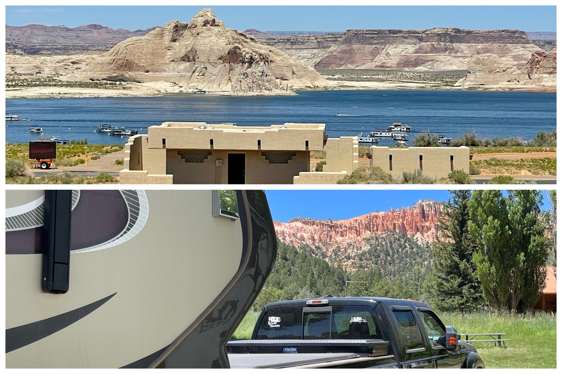
Ahhh – campgrounds with a view! The top was my view from Wahweap RV & Campground, on the grounds of the NPS Glen Canyon National Recreation Area on Lake Powell in Page, AZ. The bottom, a view from my campsite at Bryce – Zion Campground in Glendale, UT. I have absolutely fallen in love with northern AZ and southern UT. Ranks right up there as the most beautiful areas I’ve been to. Just check out the amazing places I’ve visited below. Truly incredible!
Page, AZ
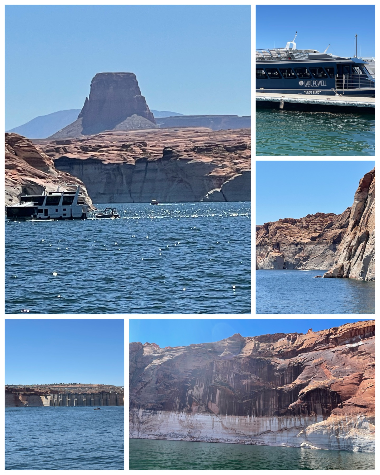 I had never been to Lake Powell before, but have heard lots about it. Mostly about its beautiful buttes and canyons, and amazing waterways providing endless recreation. Clearly, this place caters to those with water toys. Two million people come each year with their wave runners, sports boats, and most notably vast quantities of houseboats to make good use of this 163,000 acre man made reservoir on the Colorado River. To get an up-close view and perspective, I took a 3-hour tour (hoping not to get shipwrecked on some deserted island) aboard the Lady Bird. Anyone who knows me knows that I’m not much of a boat fan, but this was on a lake and not on the ocean, so how bad could it be? It actually turned out to be a wonderful tour and uneventful puke-free ride. We visited the Glen Canyon Dam (at left, bottom left) – a 710-foot tall arch dam built from 1956-1966 forming the reservoir known as Lake Powell. We also cruised into Navajo Canyon to see amazing 600-feet tall Navajo Sandstone geologic formations with
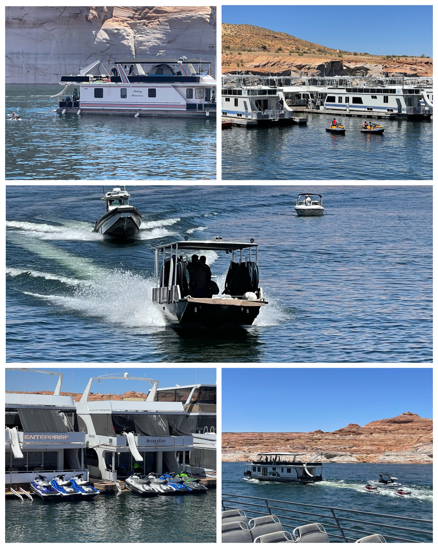 stunning colors known as Navajo Tapestry (at left, bottom right). We also took in a number of land forms including Tower Butte – the Arizona version of Devils Tower (at left – top left). Just amazing scenery as far as you can see. Truly beautiful!
As mentioned prior, houseboats are a big thing here on Lake Powell. Just during the short ride on the tour, I saw hundreds of them either sitting in a marina, or actually cruising out along the water. These are essentially floating RVs. Complete with full living accommodations, they often head out spending upwards of a month or more exploring along the hundreds of miles of Lake Powell and its many tributary waterways. I saw many having other necessities and toys in tow such as speed boats and wave runners. There is even a large collection of rentable houseboats if you care to give this lifestyle a try (no thanks). Lastly, while out on the boat tour, a couple of Park Ranger vessels came roaring by with lights and sirens blasting (at right, center) appearing to be out on some sort of a rescue mission. I hope they were successful!
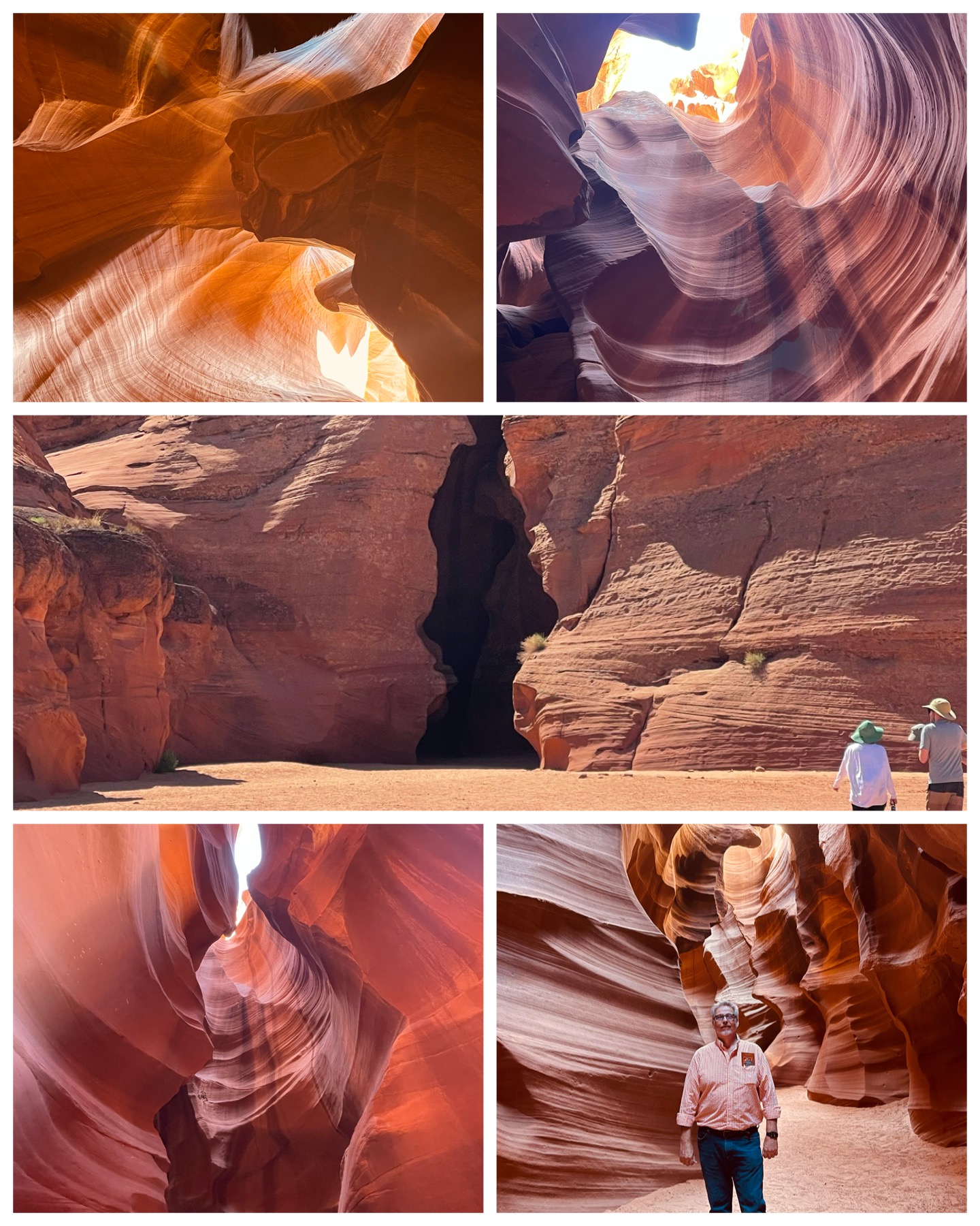 No visit to this area would be complete without touring Antelope Canyon. Famous for its amazing photos, these slot canyons were formed by the erosion of Navajo Sandstone due to flash flooding. Located on Navajo Nation land, this Navajo Tribal Park has been an accessible and popular sightseer tourist attraction since 1983. There are six separate slot canyons, and the one I visited was Upper Antelope Canyon – the one most visited and the most photographed canyon in the world with its beams of sunlight that radiate down through openings at the top of the canyon. Unfortunately, I was there early in the day when the sun was not quite high enough in the sky to create the beams of light, but the canyon was no less beautiful. The entrance to the canyon (at left, center) was really nothing special. But once you stepped inside, beautiful smooth colorful walls with waving patterns throughout takes you to a whole different world. Partial light coming down from openings at the top highlights the absolute beauty of the
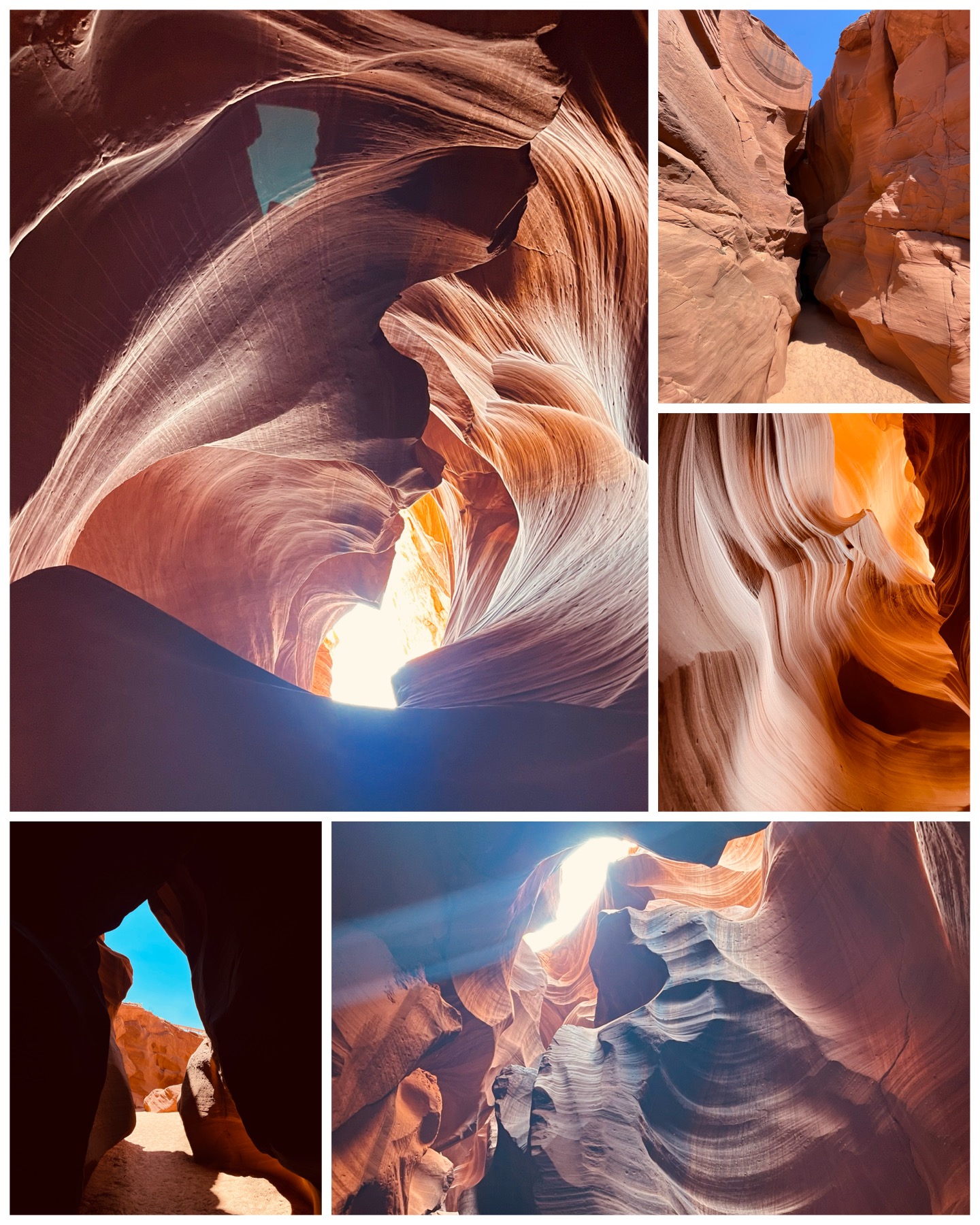 inside of this canyon. Like most things I’ve discovered in AZ and UT so far, pictures hardly do justice to the awesomeness of what you are observing in person. This is surely also true of this canyon.
This canyon is just over 650 feet long, and the walls are about 120 feet tall. The upper canyon is shaped like the letter A – wide at the bottom, and narrow at the top – and totally at ground level making for a relatively easy walk through. The lower Antelope canyon is much more physically demanding with hundreds of stairs and ladder rungs down into its V shape – narrow at the bottom and wide at the top. Needless to say, I opted for the upper! Our guide “Bear” has many years of experience going through the caverns, and is well versed in where and how to take some amazing pictures. There were a number of places where he would take our phones, adjust the camera settings manually, then take the most incredible pictures – many of which are featured here at right. He really was talented. Flash flooding remains one of the most significant concerns for visitors, so keeping tabs on the weather is an important task. The rain does not even have to be occurring locally, but rather could be many miles away and can still cause flooding in the canyon. There are a number of YouTube videos that demonstrate AZ flash flooding – one in particular from this same canyon in July 2010 HERE. Despite the flood risks, this is absolutely a must stop if you are in the area.
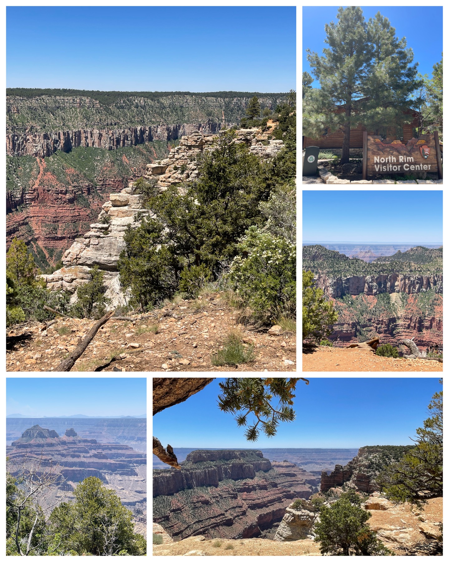 Well, I made it back to the Grand Canyon for a second look – this time from the vantage point of the North Rim. I can see now why of all the millions of visitors that come to see the Grand Canyon, only 10% of them do so from the North Rim. It certainly has nothing to do with a less magnificent view as the canyon was equally spectacular from here, but rather I believe due to its absolute remoteness and limited accessibility. This part of the park is only open between mid May and mid Oct due to heavy snow during a prolonged winter. In fact, despite me having gone there towards the end of June, I still saw several small piles of un-melted snow in shaded areas along the sides of the road leading to the visitor center.
I left my RV at the crack of dawn – 8:30 am (which for a retired guy is definitely early) and did not get back home until after 6:00 pm. Just the drive from the campground to the visitor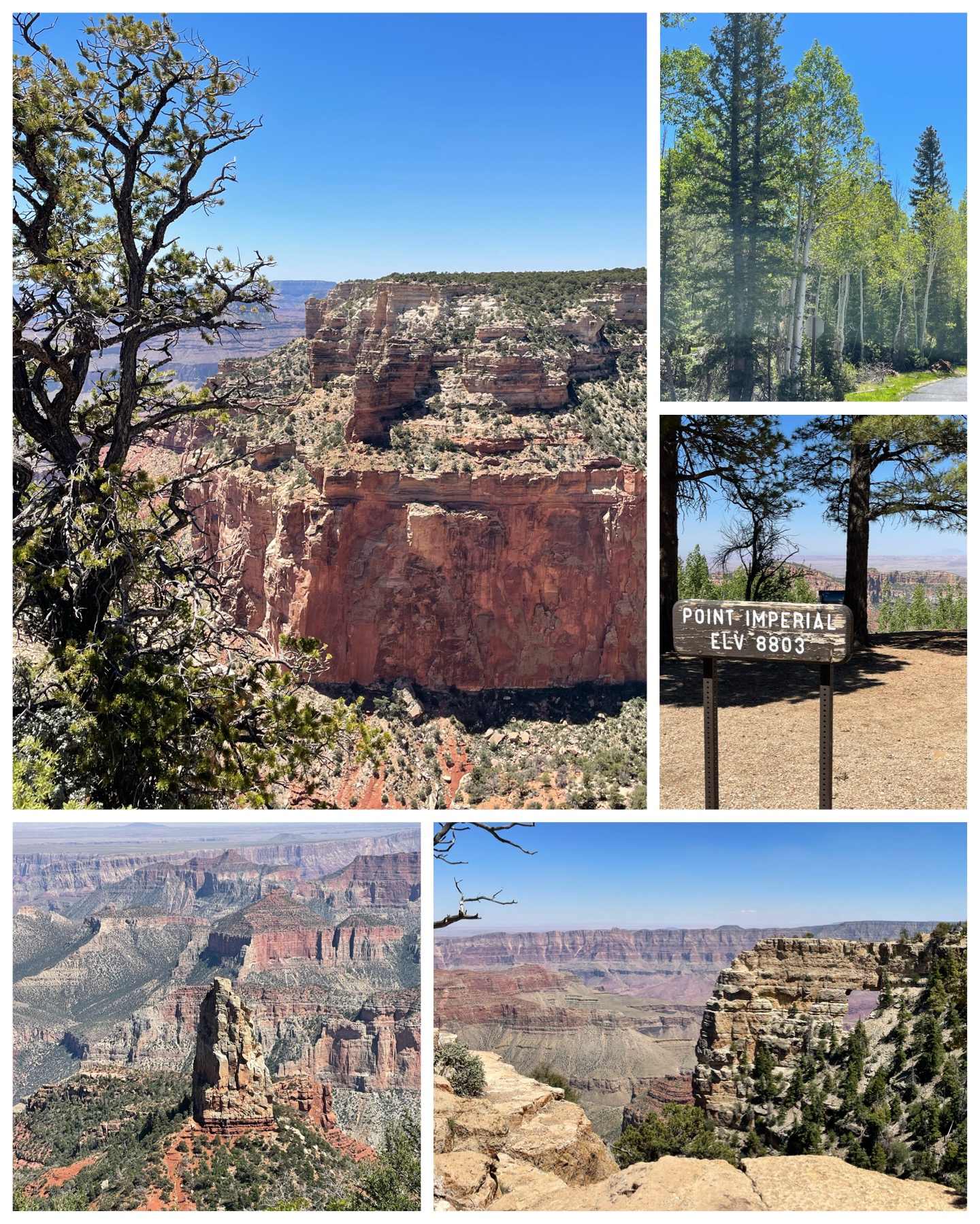 center was 2 hours and 40 minutes, covering 130 miles. Once there, in order to see all the various scenic overlooks and such, you have to travel an additional hour, climbing and descending various mountains through endless switchback roads, finally reaching the dead end view areas known as Angel’s Window (at right, bottom right) and Cape Royal Point. The views are absolutely breathtaking, and once again, pictures don’t even come close to the in-person views. This side of the canyon was definitely greener compared to the south rim – the north having lots of pine trees in and around the walls of the canyon. I also found the somewhat long drive to the visitor center to be quite relaxing as well – passing various flat grasslands along with hillsides of pines and especially the white barked aspen trees (at right, top right) which were plentiful all throughout the area. Also, the lack of crowds almost made you feel like you had the entire place to yourself. Coming back from the Cape Royal Point required you to negotiate the one hour switchback road once again, then the full almost three hour drive back to the RV. So, all in all, there was a lot of driving. But, it was most certainly a worthwhile trip to see one of the most spectacular national parks.
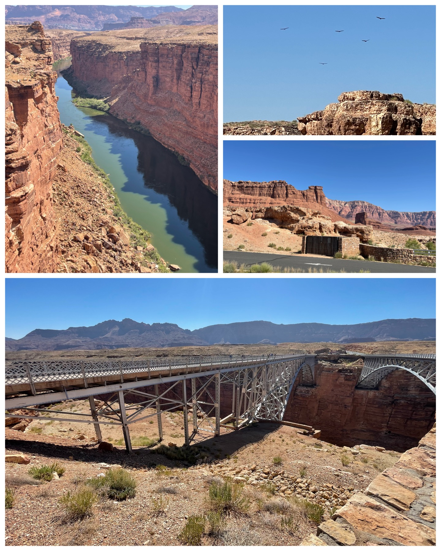 On the way to the North Rim, I was fortunate to drive past a couple additional interesting stops. First up was a visit to the historic Navajo Bridge. Between Bitter Springs and Jacob Lake, AZ along route 89A, you will come upon two bridges spanning across the Colorado River – one old, and one new (pictured at left, bottom – the bridge one on left is the historic bridge). This bridge is only one of seven in existence that cross the Colorado River for 750 miles. The historic bridge was built starting in 1927 and completed in Jan 1929. Its opening was a huge event that was celebrated by over 7,000 people and upwards of 1,200 cars – which for back then was quite a lot. Originally called the Grand Canyon Bridge, it was later renamed to Navajo Bridge in 1934. This bridge served the surrounding community well for the next 66 years. However, as cars grew larger and trucks grew heavier, a more robust bridge was deemed necessary. Construction began just a bit upstream in 1993, and was completed in Sep 1995. The old bridge became a pedestrian bridge offering spectacular views of the Colorado River some 467 feet below. An interesting piece of bridge trivia is that the original 1929 bridge cost $390K to build, while the budget for the new 1995 bridge came in at almost $15M. Geez – prices sure have gone up! One of the other special treats I got to experience at Navajo Bridge was to see critically endangered California Condors (at left, top right). With a near extinct population of 22 in 1982, a captive breeding program followed by a release and subsequent natural expansion, the population has grown to just over 500 today. With their 10-foot wingspan, it was awesome watching these giant birds soaring along the canyon walls in this mid-morning visit.
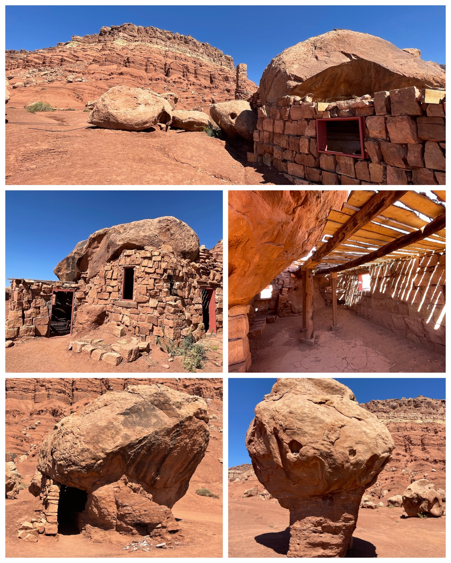 My second stop on the way to the Grand Canyon was to pay a visit to the old Stone House along the Vermillion Cliffs. Besides being a very scenic view along the red cliffs of Marble Canyon, there were several rock forms and even this house made of rock. The mushroom rock (at right, bottom right) is just one example of the many large rocks that formed crevices, caves, and overhangs through natural erosion over many hundreds and thousands of years. Many of them served as the basis of temporary, or in one case, permanent shelter. So would be the case of the Rock House (at right, top and center). This home was reportedly built by Blanche Russell – a Ziegfeld Follies dancer from the mid 1920s, along with her husband Bill. They were out touring the country and reportedly had their car break down in this area of Marble Canyon. She used tarps and ropes and the overhang of a large rock to take shelter for the night. Over the course of the next few days, she fell in love with the area and views, and ended up purchasing some of this land. She built several structures in the area, including a restaurant down the road a bit. But none would be as beautiful as the stone house. Today, this area serves as a popular tourist stop, often accompanied by Native Americans who setup small roadside businesses selling mostly Navajo made jewelry and other artifacts. A really interesting stop in an otherwise desolate, yet truly beautiful area.
Glendale, UT
My next travel day takes me across the AZ boarder into Utah to the small town of Glendale. Actually, the campground is 6 miles north of town, sandwiched between mountains making up the Dixie National Forest. Alas I have absolutely no Verizon or T-Mobile cell service here, but my AT&T hotspot saves the day with a couple bars of somewhat usable Internet. Hence, goes to prove the absolute necessity of having Internet service from multiple carriers – one of them is bound to work! I’m here for the next two weeks, as there are several National Parks to visit, along with upwards of 20+ Roadside America sites to take in.
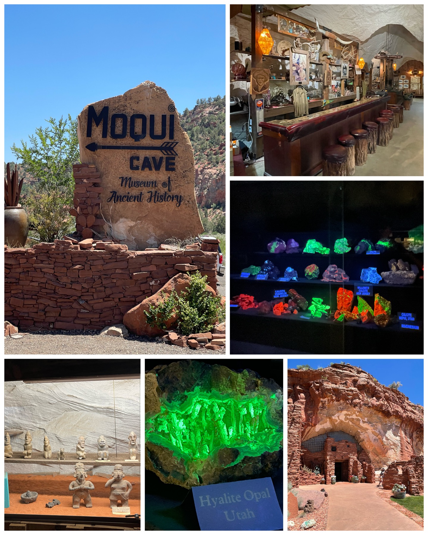 First up was a trip south towards the town of Kanab. Along the way I stopped at Moqui Cave just north of town. After serving as a shelter and food storage by the Anasazi people according to archaeological digs, the cave was rediscovered at the turn of the 19th century and used as a speakeasy during prohibition. In 1951, the cave was purchased (who knew you could purchase a cave?) by Garth Chamberlain. Inside the cave, he created southern Utah’s first Bar (at left, top right) and dance hall. The bar still remains, while the rest of the cave has been filled with the personal collection of various finds by Garth who was a professionally trained archaeologist and paleontologist. This includes ancient artifacts, naturally luminescent stones shown under a black light, and even various dinosaur bones. Garth passed away in 1992, and his family continues to own and operate the now tourist attraction. In fact, it was his granddaughter that welcomed me into the cave, collected my admission fee, then provided a brief overview of the cave’s history before turning me loose on a self guided tour. It was a really cool and interesting stop.
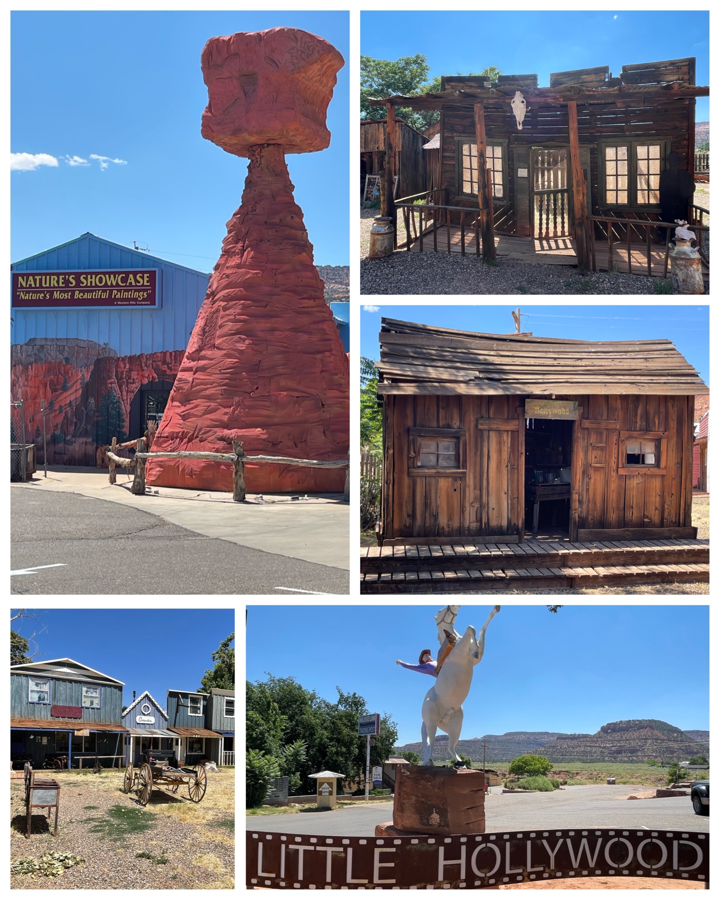 Downtown Kanab would provide the backdrop for the next several Roadside stops. One of its claims to fame, Kanab is referred to as “Little Hollywood” by the locals – as it has a long history as a filming location for lots of movies and TV shows. These would include most notably several westerns such as The Lone Ranger, Gunsmoke, and Daniel Boone, as well as many non-western titles to include Planet of the Apes, Apple Dumpling Gang, the James Garner/Jodie Foster Disney movie – One Little Indian, and even several episodes of The Six Million Dollar Man. I visited Frontier Movie Town, a sort of museum that features several sets used in movie making and other local events. Included here was a cabin used in One Little Indian (at right, center right), and the western themed cabin (at right, top right) used as the background for the 1992 Kenny Loggins Live from the Grand Canyon concert. I did a YouTube search of that concert, and found several videos from it that showed this cabin in the background. One such example can be clearly seen at the 1:05 mark of this video HERE. Then, just across the street, is this other Roadside item of a once concrete TeePee turned into Thor’s Hammer sitting outside of a rock shop. Very interesting!
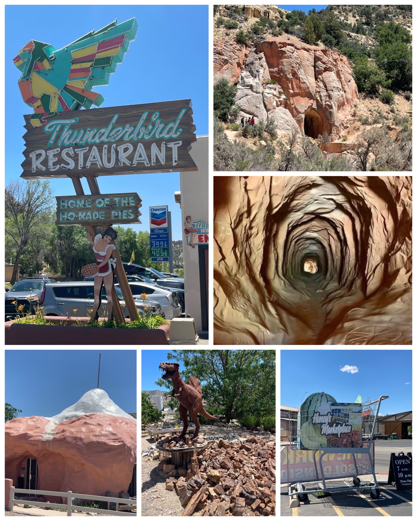 Last up on this days adventure was a visit to several other Roadside items. First up, I stopped for lunch at the famous Thunderbird Restaurant – best known for their “Ho-Made Pies”. This circa 1931 establishment features this whimsical neon sign that I’m not sure how it started, but it is kinda funny. Lunch was great, but the slice of strawberry/rhubarb pie was priceless! Next, I visited a rock shop whose building is designed like a rock. Lots of interesting specimens there, including a large pile of petrified wood. Next, I visited a site named the Belly of the Dragon. This is actually a man made tunnel that serves as a floodwater culvert under US Hwy 89. Natural erosion has made this into a very interesting site. Access to the tunnel entrance was a bit challenging so I didn’t actually go inside and accordingly I only took photos from the outside (at left, top right). I did, however, borrow someone else’s photo (at left, center right) that shows what the inside looks like. Very cool! My last stop of the day was a combined stop – to check out a giant shopping cart, and to actually do some grocery shopping. Located in the parking lot of Honey’s Marketplace, this oversized shopping cart provides interest to attract customers. Well, it worked for me!
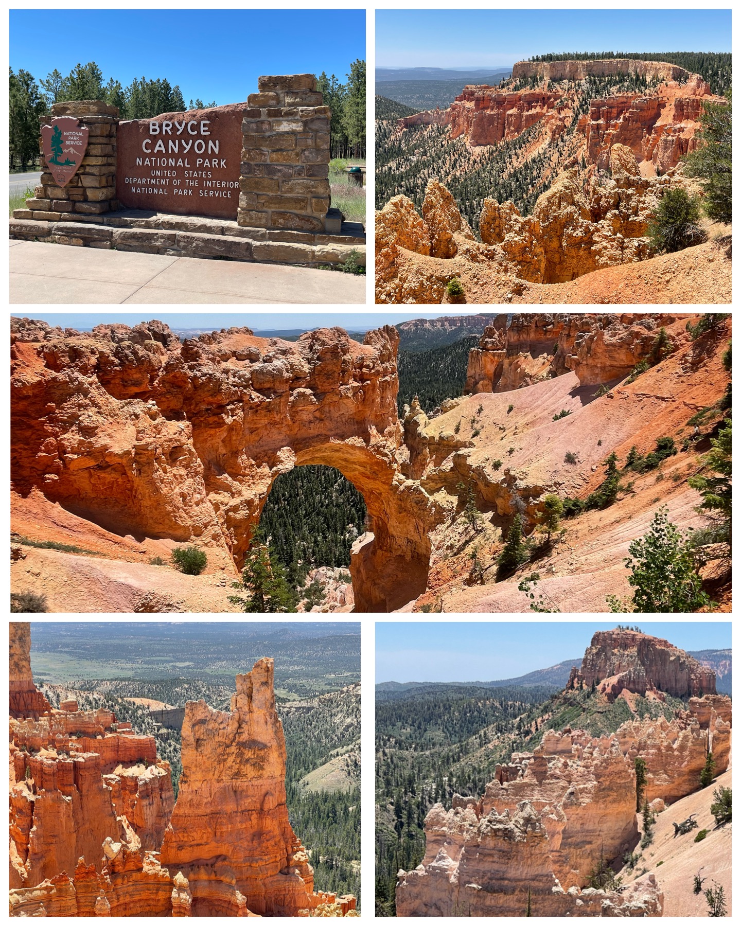 When it comes to National Parks, southern Utah has more than its fair share. Five to be exact, all within a few hundred miles of each other. My first NP visit here would take me to Bryce Canyon NP. Just when you thought the Grand Canyon was the most amazing, now I get to see a different kind of amazing canyon. With its red and orange jagged spires called Hoodoos standing tall along amphitheater-like canyon walls, the breathtaking views of Bryce Canyon has proven to be just another gem among our nations best. From the visitor center just south of Rt 12, the 18-mile switchback known as Bryce Canyon Road, or Rt 63, takes you to some of the most awe inspiring views. This includes perhaps the best known view of what is called Natural Bridge (at right, center). Bryce Canyon Rd dead ends with more awesome views from Rainbow and Yovimpa Points (at right, top and bottom right). Now, a little history. The park is just over 35,000 acres, with elevations ranging from 8,000 to 9,000 feet. So, it was definitely a lot cooler up there than back down on lower earth. First designated as a National Monument by President Warren Harding in 1923, it was later redesignated as a National Park by Congress in 1928. It welcomes over 2M visitors per year – roughly half of what nearby Zion National Park sees (I can certainly vouch for that – more details below when I write about my visit to Zion). This lower visitor rate is thought to be presumably due to its more remote location. I didn’t actually find it that remote – certainly not when compared to the North Rim of the Grand Canyon! Anyway, it was a glorious full afternoon of wondering down the canyon road, and checking out the many stops along the way. It truly is an amazing National Park!
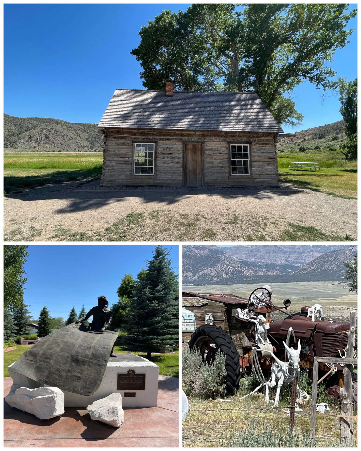 Next, I took a day and chased a few Roadside America sites. They were not anything spectacular, but interesting enough for this old retired guy to burn up a day to pay them a visit. First up was the Quilt Walk Survival Statue. Located in Panguitch, UT, this statue commemorates the heroic men who during the winter of 1864-65, travelled in deep snow to the next town 40 miles away in search of food and supplies. The snow was so deep and crusty, they flung a blanket across it, walked to the end, retrieved the blanket and flung it again – over and over again working their way along their destination. That sure is a wicked way to travel 40 miles! Next up in Spry, UT, was this crazy skeleton collection – one in the drivers seat of an old tractor. This house was in the middle of nowhere UT, and apparently its owners wanted a bit of attention so they created this skeleton diorama in their front yard. Definitely interesting! Last up was a visit to the childhood home of Butch Cassidy in Circleville, UT. Being listed as his childhood home is a bit of a misnomer, as he was actually a teenager when living here between 1880 to 1884, and only having lived here for those four years. But none the less, this is where he hung his hat back in the day. It’s a fairly simple cabin, located in very rural southern UT, with no other house around for a far as you can see. Poor kid – he must not have had too many local friends to play with back then!
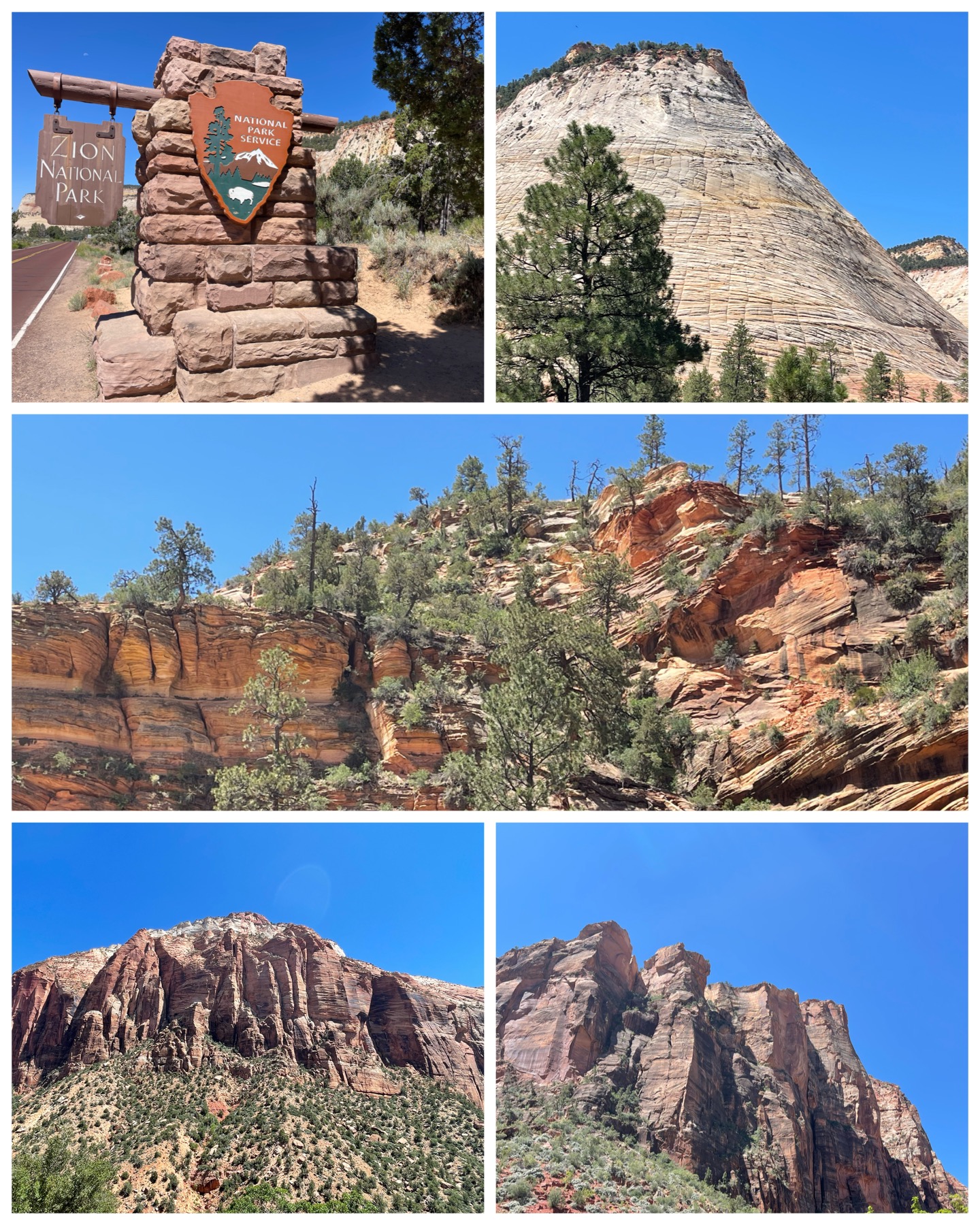 My next day trip would take me Zion National Park. I approached the park from the east on Rt 9, giving me an opportunity to enjoy all the beautiful scenery and view stops along the way to the visitor center 20+ miles down the winding road. When I arrived at the park entrance, I presented my Veterans Lifetime Pass – prepared to be waived thru having no cost for admission. Well, I figured wrong! They charged me a $15 “you’re too fat” fee (referring of course to my big boy dually truck, and not me personally). About half way down Zion Park Blvd, there is a 1.1 mile tunnel that was built and completed in 1930. Apparently, its not well suited to today’s oversized trucks and RVs, so in order for us big boys to get through, they have to stop traffic coming from the other direction – thus turning the complete length of the tunnel into a one-way to provide sufficient space to get through. It would seem that for the inconvenience of doing so, they charge you $15. I think it was well worth the cost so I didn’t have to panic with the tight squeeze while traversing that tunnel. So that was fun! I finished the drive and was heading for the visitor center. You see, there is another park road that goes north from the center, with several interesting stops along the way. This includes the beautiful park lodge, and many other scenic overlooks. However, this road is not open to public vehicles, but rather only to the park bus and tram. So, I was going to check out the visitor center, then jump on the tram to see the northern part of the park. Well, that was good thinking, but alas turned out to be a bust. This park sees over 4M visitors a year – many of whom apparently decided to show up on the same day as I did. Not only was the standard car parking area totally full with lots of folk’s circling like vultures for a spot to come open, my run through of the oversized truck and RV area also turned out to be a fail as it was completely full too. I meandered around for about 20 to 30 minutes hoping something would open up, but it never did. So, I gave up and moved on. Ultimately, it would only be the eastern portion of the park that I would see that day, but as you can see from the pictures at right, and the video below, that was quite the beautiful view in and of itself.
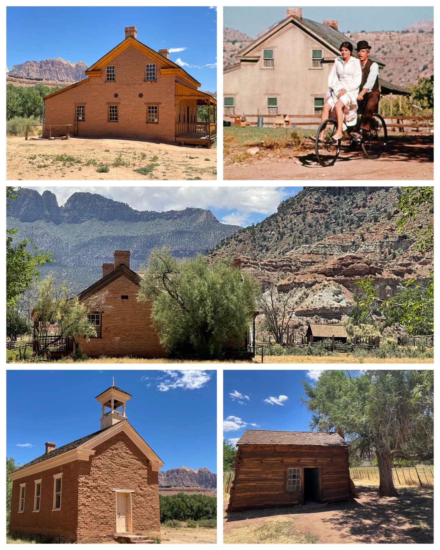 After the shortened tour of Zion, I decided to continue my way west on Rt 9 to check out a few Roadside America sites. My first stop would take me to the Grafton Ghost Town. This place was way out in the boonies, necessitating I cross a sketchy bridge followed by a 3 mile ride on a washboard dirt road. But, the end result was certainly worth it. What I found was a collection of historic homes, green pastures, and stunning scenic views on the banks of the Virgin River. Also known to be the most photographed ghost town of the west – it was so beautiful! So, a bit about its history. The area was first called Wheeler and settled in 1859 at the request of Brigham Young to develop cotton farms. Flooding in 1862 wiped out the town, so they rebuilt a few miles upstream and renamed it Grafton. Several homes and cabins were built, as well as a combo church and school. The area did well and grew to 28 families by 1864. In 1866, Indian attacks and the threat of repeated flooding caused most families to leave. By 1890, only four families remained, and by 1921, the town was pretty much done. The town was purchased by movie producer Harry Sherman in 1946 to be used as a film location. Hollywood would use this site for several movies – including the 1929 first outdoor talkie
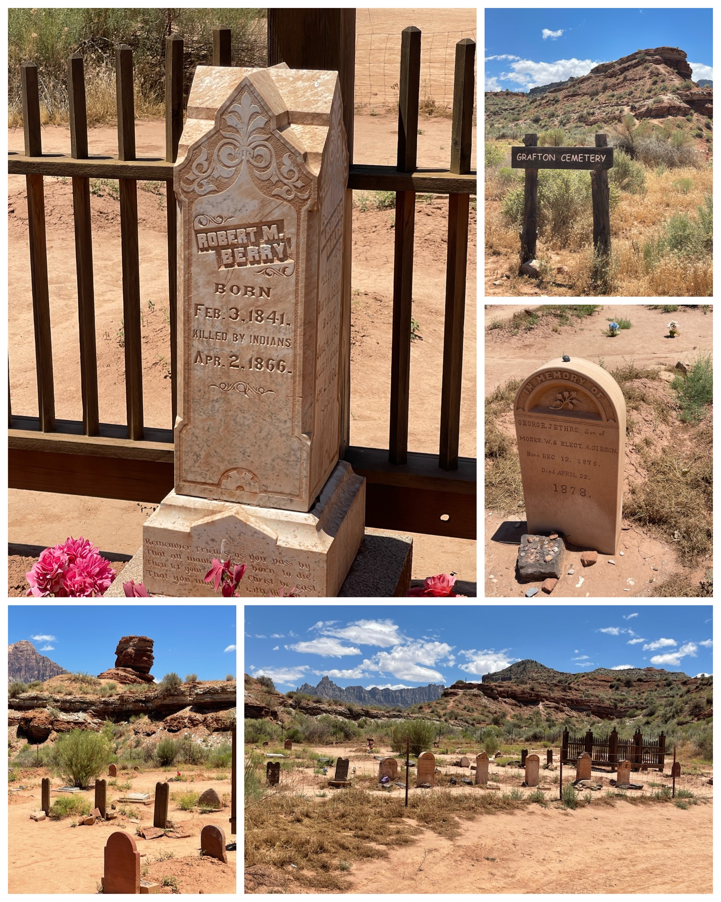 titled “In Old Arizona”, and in 1969 for “Butch Cassidy and the Sundance Kid” starring Robert Redford and Paul Newman. Compare the photo I took (at left, top left), with a still from the Butch Cassidy movie (at left, top right) – certainly confirms this scene was shot here. In 1997, a group called the Grafton Heritage Partnership came together to restore, preserve, and protect the townsite and have done a terrific job. It truly is a beautiful ghost town!
Just up the road from the town is the Grafton Cemetery, with many of the towns residents from the 1800s buried here. According to one tombstone (at right, top left), Robert Berry was killed by Indians in 1866 at the young age of 26. Signage in the area noted five 3-10 year old deaths due to Diphtheria, three 20 something’s killed by Indians, 2 infants lost to Scarlet Fever, and a 13 and 14 year old that died in a broken swing accident. Sure was tough to live back in those days. But, at least they are at peace, resting in an area with spectacular views. Not a bad way to go after all.
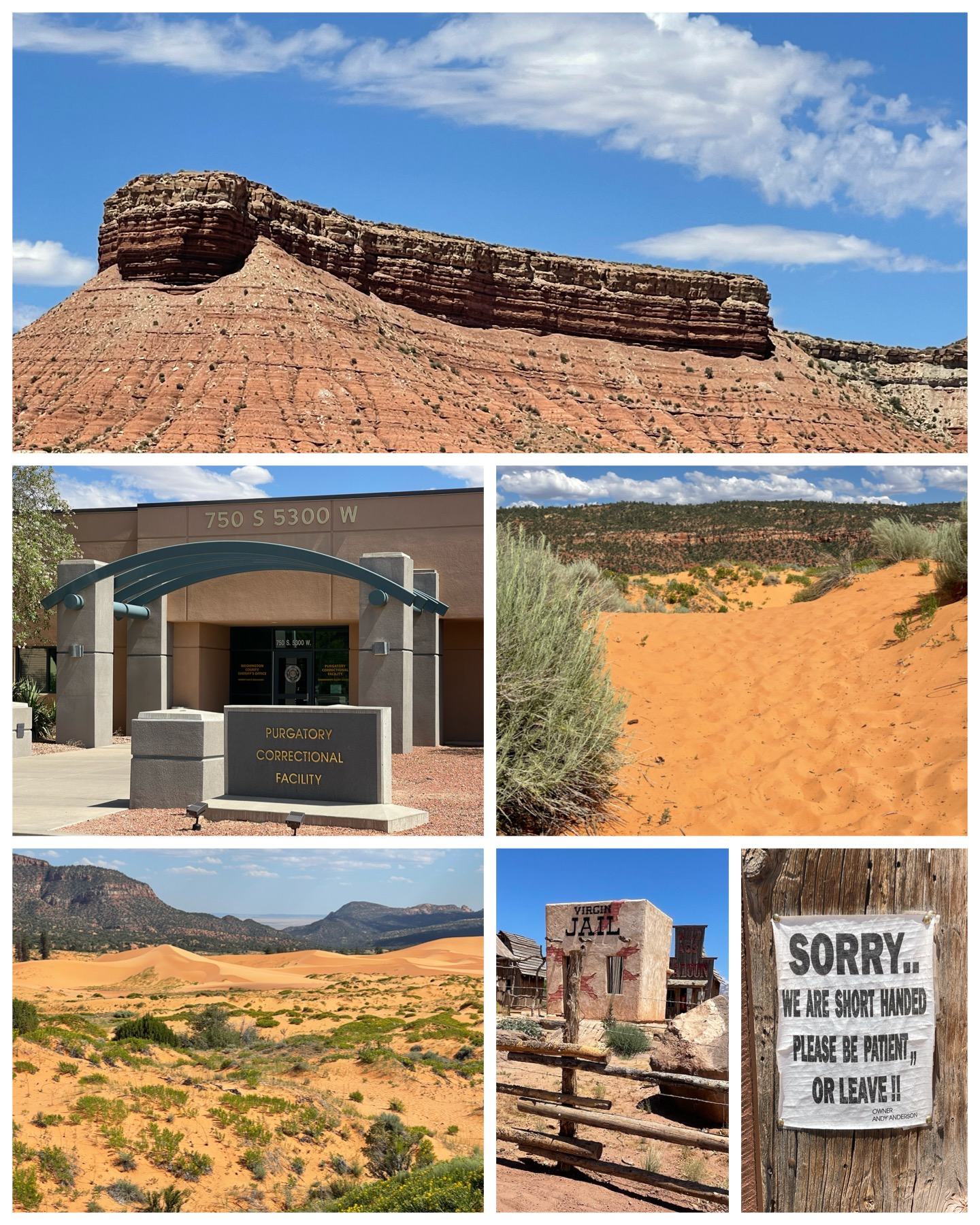 Last up on my post Zion bust trip, I travelled towards the town of Hurricane to check out a few more Roadside items. On the way there, I stopped in Virgin, UT to visit a touristy trading post called Fort Zion (at left, bottom center and right). It wasn’t much to see, but I certainly did get a chuckle at the sign posted at the entrance door stating “Sorry .. We are short handed. Please be patient, or leave!!”. Well, that certainly is direct and to the point! My next stop was in Hurricane at the county detention center – aptly named Purgatory Correctional Facility. The actual name reportedly comes from early LDS pioneers who named this area of the desert Purgatory after having a difficult time crossing it. There is no town in Utah with this name. But it would seem the local government perhaps had a sense of humor and decided to bequeath the name upon this prison. So the saying goes, if you break the law in Hurricane, you are certainly going to Hell! Then on the long drive back to the RV, I would happen to pass the Coral Pink Sand Dunes State Park. Located in the middle of nowhere, these beautiful dunes were formed from the erosion of pink-colored Navajo Sandstone that surrounds the park. Established as a Utah state park in 1963, this 3,300 acre area provides a wonderful hiking, camping, and off-road vehicle driving recreational area. Really cool! Last up, though not on any Roadside list, I just happened to stumble upon this unique geological anomaly (at left, top). I imagine it has some sort of official name, but to me, the first thing I thought of was the beached remnants of Noah’s Ark. It certainly looks like something that could have been built to carry two of each kind of animal. Anyway, I pulled over for a quick pic, and thought I’d include it here. What does it look like to you?
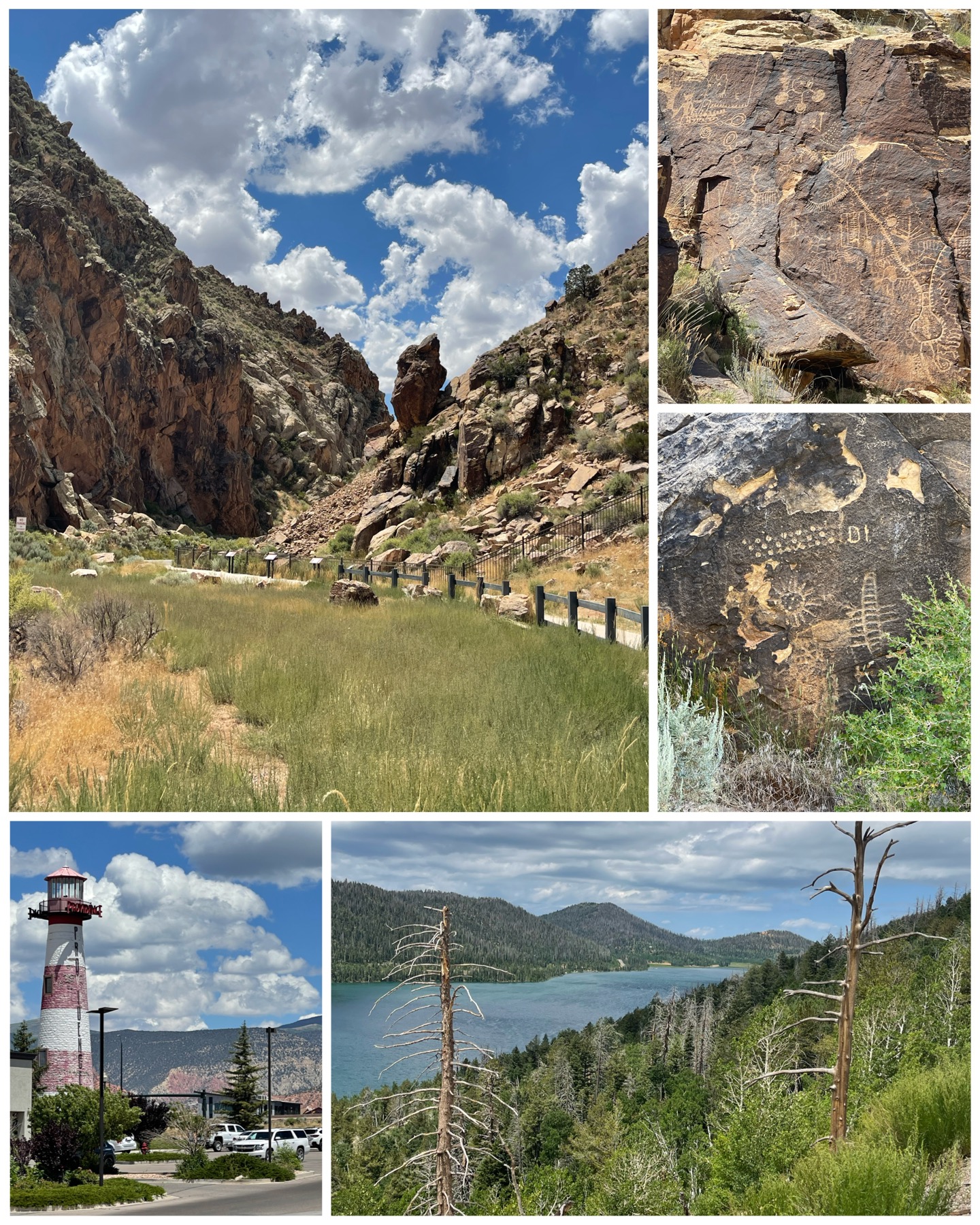 I spent my final tourist day in Glendale heading out a bit to the north east to Cedar City, UT. There, I was supposed to see two Roadside items, one being the landlocked lighthouse (at right, bottom left), and the second were a couple of monuments in a small park that no matter how I tried, I could not get to due to roads being torn up all around. So, I was left only seeing the lighthouse. It was kinda cool despite it being somewhat weathered and faded. Built in 2000 in the Providence Shopping Center, and at the time of construction, was the tallest inland lighthouse in the US at 88 feet. Now they just need some water to make it look legit! Then I drove further north to the Parowan Gap Petroglyphs (at right, top). Besides being located in an incredibly scenic location, the ancient artwork, believed to have been done by various culture groups several centuries ago, were plentiful and present within both sides of the gap. While the actual meaning of the designs remain unknown, they are sure to tell a story of ancient times. The visiting area was also nicely setup with ample parking, and sidewalks on either side of the road to easily navigate for perfect viewing. Nicely done Utah! On my drive back to the RV, I stopped by to check out the beautiful Navajo Lake. This lake formed when a prehistoric lava flow from a nearby volcano created a dam on the east side of the valley. Amazing what Mother Nature can produce!
Final Thoughts
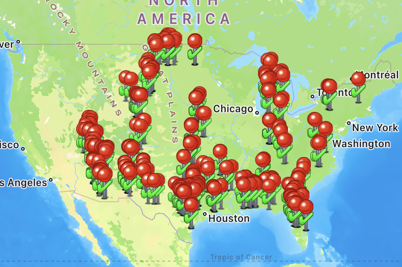 As noted above, I’ve really loved exploring around this area. So much beauty packed into such a seemingly small part of the country. I’ve got three more weeks in two stops to enjoy more of southern Utah before heading up to Salt Lake. During this time, I’ll check off three more National Parks, and no doubt many other amazing sites to see. On a side note, I’ve crossed the 500 mark with Roadside America, having visited 544 locations as of this writing. It’s clear from my visited map at left that I’ve got the PNW and west coast to travel through yet. It would also seem that I’ve got a few gaps in the middle of the country as well that are in need of some attention. To be addressed via future travels no doubt. I’ve also reached the 150 mark with Roadside in terms of submissions – either via a written tip or photos or both. So, I’m definitely doing my part to keep and maintain and improve the usefulness of this wonderful nomad sightseeing service. Till next time, be well and safe travels.
I only show a sampling of my adventure pictures here in the blog, and do so mostly in collage format for brevity and ease of reading. If you want to view an album containing individual full fidelity and hi-res images of all my travel pictures related to this specific blog, click the image below. Enjoy!

Great blog Bruce! Pictures are amazing. The geological anomaly looks like a train stuck in dirt to me. Keep up the good work and have safe travels.
Thanks for the comment. Yea, I can definitely see a train stuck in the dirt with that geological formation. It really was strange looking.
Wow, Bruce, beautiful scenery! You’re writing is also wonderful. For a few minutes, it almost takes me to the places you are describing. Thank so much for sharing and continued safe travels.
Blanca
Hi Blanca – so nice to hear from you! Thanks for the kind words regarding the blog, and I’m glad you get to take a little trip along with me. I’m really having a great time with all my travels, and writing the blog has been a lot of fun for me. I’m going to get a chance to catch up with Mary in a couple months when my travels take me near Toledo. I’m looking forward to that. I do hope all is well with you and Richard. I’ll be in the area of New Market at the end of Oct, which looks to be just under an hour to Front Royal. Would love to grab lunch with you folks if the opportunity presents itself. I’ll reach out when I get closer. Take care!
And love the Butch Cassidy house and the bike with Butch and Etta (Paul Newman Great blog Bruce. Beautiful pictures. Having been there I can attest to the beauty and majesty of the Grand Canyon. And your writing is fantastic and I, too, feel like I’m there with you.
The geological anomaly looks like a Disney World Tram to me lol.
and Katherine Ross). One of my favorite movies. I can hear BJ Thomas singing “Raindrops keep falling on my head 🎶 🎵 🎼 “
https://youtu.be/_VyA2f6hGW4. Some of the scenery in the song video looks like some of your pictures.
Safe travels to your next stop.
😉
Yup – Disney Tram would definitely be a match to that geological thing. Nice call! I watched the video, and sure enough, that background sure looked familiar. Even the final scene where they were on horseback riding through some sandy soil looked like areas I saw near the cemetery. I don’t recall the big barn though, but I could have missed it. There were several buildings in the area. Then again, that movie was made over 50 years ago, so that barn might not have survived. Cool music video though!
Nice blog as usual.. I remember visiting both the north rim and Bryce canyon years ago .. both spectacular .. looks like lake Powell is well below the high water mark kind of like lake Mead .. enjoy the rest of your stay in the area
These national parks are for sure amazing. Like nothing you would see elsewhere in the country, and certainly not well represented in pictures. As for Lake Powell, it is low. It recorded its lowest level in Apr of 2022 – when it was down around 185 feet from its high mark recorded in 1983. As of now, it is up 45 feet from where it was a year ago, so they are making some progress. Hopefully some late season monsoons will fill it up a bit more in the coming months.
Great sites! So glad you introduced me to Roadside because it offers so much that I would have otherwise left for others. You saw some wonderful places Bruce! I hope you are not disappointed anywhere else! Stay safe!
I’m glad you’ve embrace Roadside. It has certainly taken me to so many interesting places. Never a shortage of things to see no matter where you are. I hope you enjoy where it may take you!
Wow stunning views for sure. I loved my drive through Utah last fall, definitely the best road views I have ever been on. Looking forward to your next blog as you journey through Utah.
For sure, Utah has some absolutely amazing scenery. My next stop will take me to the other three national parks – something I’m really looking forward to. Certainly no shortage of cool places to visit down here in southern Utah. Have a great trip up to New England!
It is a beautiful area!! I haven’t been to Zion, but Bryce Canyon is probably my favorite out there. Absolutely breathtaking! You didn’t mention going there – if you missed it, you must go back to see the hoodoos!! Utah has so many wonderful places to visit – just gorgeous. Glad you are getting to enjoy it.
Just remember – it’s a ‘dry’ heat! LOL
Have fun and continued safe travels!
Hmmm – perhaps you skipped over it in this blog, but I certainly did visit Bryce Canyon and the Hoodoos, and covered it here in this blog. I agree with you – it was absolutely breathtaking! The spires along the canyon walls were so different than anything else I’d seen in the area. In fact, from my campground, I had the view of a spire filled mountainside that was amazing. Certainly no shortage of beautiful scenery around here. Hope all is well with you!
Yep – missed it. Glad you got to see it!! 🙂
Wow. Of all the places you visited I have only been to two of them, Bryce and Zion National Parks. The photos look great and all I see is blue sky so it looks like you are having great weather.
Well, glad I could introduce you to some new areas. Possibly places you might pay a visit to yourself someday. As for the weather, it has certainly been sunny and dry – but alas a bit too hot at times. I’m currently stuck in this damn heat dome which is brining triple digit temps daily. In looking ahead, it looks to be more of the same. At this point, I would welcome some rainy days in order to drop the temps down a bit. But alas, the forecast is calling for sunny skies and hot for the foreseeable future. I’m glad the weather was not too rainy during your cruise. It didn’t appear that the clouds hampered your sightseeing that much. Loved all the pictures and write ups from those adventures. Looks like it has been a great time.
Excellent blog. I am glad you are able to stay in your visit schedule despite the three digit temperatures. In Livermore, California this week I stopped by a Roadside America Attraction – First Street Ale House and viewed the over 6000 beer can collection. I went after 5 pm – a little cooler part of the day. Thanks for the suggestion. The collection is organized in display cases. For example, one case had beer cans from USA Georgia thru Guam. I’ll have to go to your other two suggestions during the day. The Fire Station for the longest continuous bulb looked a little deserted when I stopped by and The Discovery Center wasn’t open when I stopped by. Still time to fit it into my schedule 🙂
Nice – that beer can collection sounds awesome! I’ll have to be sure to visit it when I’m in that area. I hope you have the opportunity to make it to the other nearby Roadside attractions. So much to see in this country!
Yes and the beer cans are in alphabetical order. It is a very big tavern inside – pretty busy. I stopped by the Fire Station earlier in the day and rang their door bells. No answer. Considering it was 101 degrees, there are local wild fires and they probably had people having heat emergencies, they were probably out on a call. I plan on visiting the Discovery Center Wednesday afternoon. They are only open noon- 4 M-F. The weather is cooler off here at the end of this week. Enjoy 😊