You surely know you are in Utah when you see a magnificent Temple such as this as a centerpiece of a remote rural town with a population of only 3,000. But it, like many of the amazing things to see here, exemplifies the beauty that exists here in southern Utah. I wrapped up my visits to the Mighty Five national parks, and toured various Roadside America sites that were just incredible. So, buckle up and lets get to all the details.
Richfield, UT
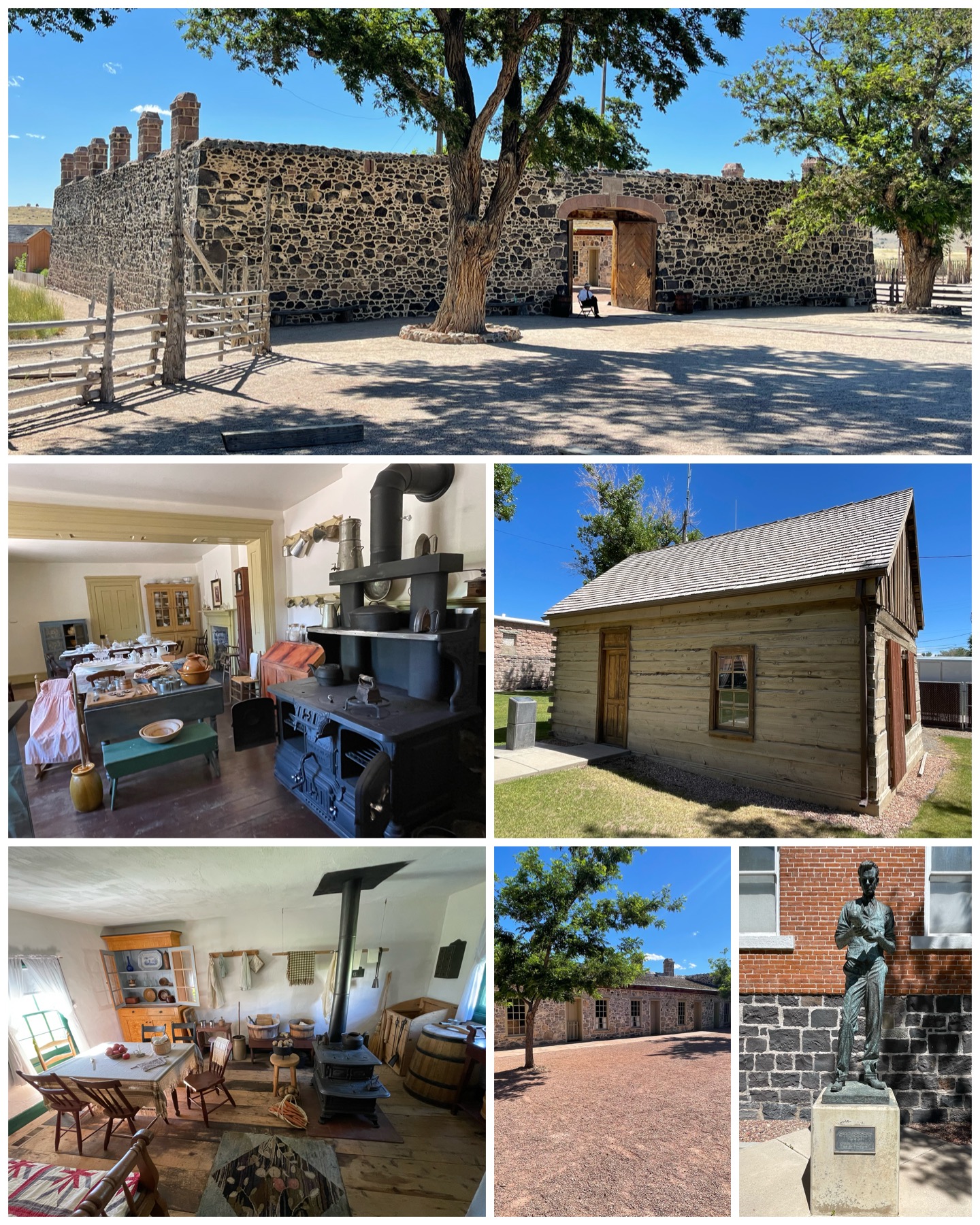 I got to spend a week in Richfield, which was just about right. There were no national parks to visit in the area – where of late I’ve become all too accustomed to spending my time in. Instead I simply got to enjoy the many opportunities that existed in the area otherwise. And in fact, there was much to explore. I started out heading to the southwest to the town of Beaver, UT. This 3,600 person town has a few notables – it was the birthplace of Butch Cassidy on Apr 13, 1866, and also to Philo Farnsworth on Aug 19, 1906. If you’ve never heard of Philo, join the club as neither had I. I stopped by to visit his birth cabin (at left, center right) and the statue of him (at left, bottom right) both of which are on the grounds of the town’s city hall. Philo is credited for essentially inventing the television. Wow – where would be be today had it not been for him? Anyway, when he was a boy living on a farm, it was the back and forth motion of field plowing that inspired him to dissect then recreate images one line at a time. Thus was born the all electronic video camera and television. He was quite the prolific inventor having upwards of 300 patents to his name, and who was posthumously inducted into the National Inventors Hall of Fame in 1984 – some 13 years after his death. Next, I visited Cove Fort (at left, top). This was built in 1867 at the request of Brigham Young to serve as a protected telegraph relay point and as a stopping place for travelers. The fort had six rooms on either side, consisting of bedrooms, kitchen and dining, a post office, and the telegraph room. Stagecoaches would stop there daily, as would other travelers. Though it was a fort, there was never a shot fired in its history but for the one time
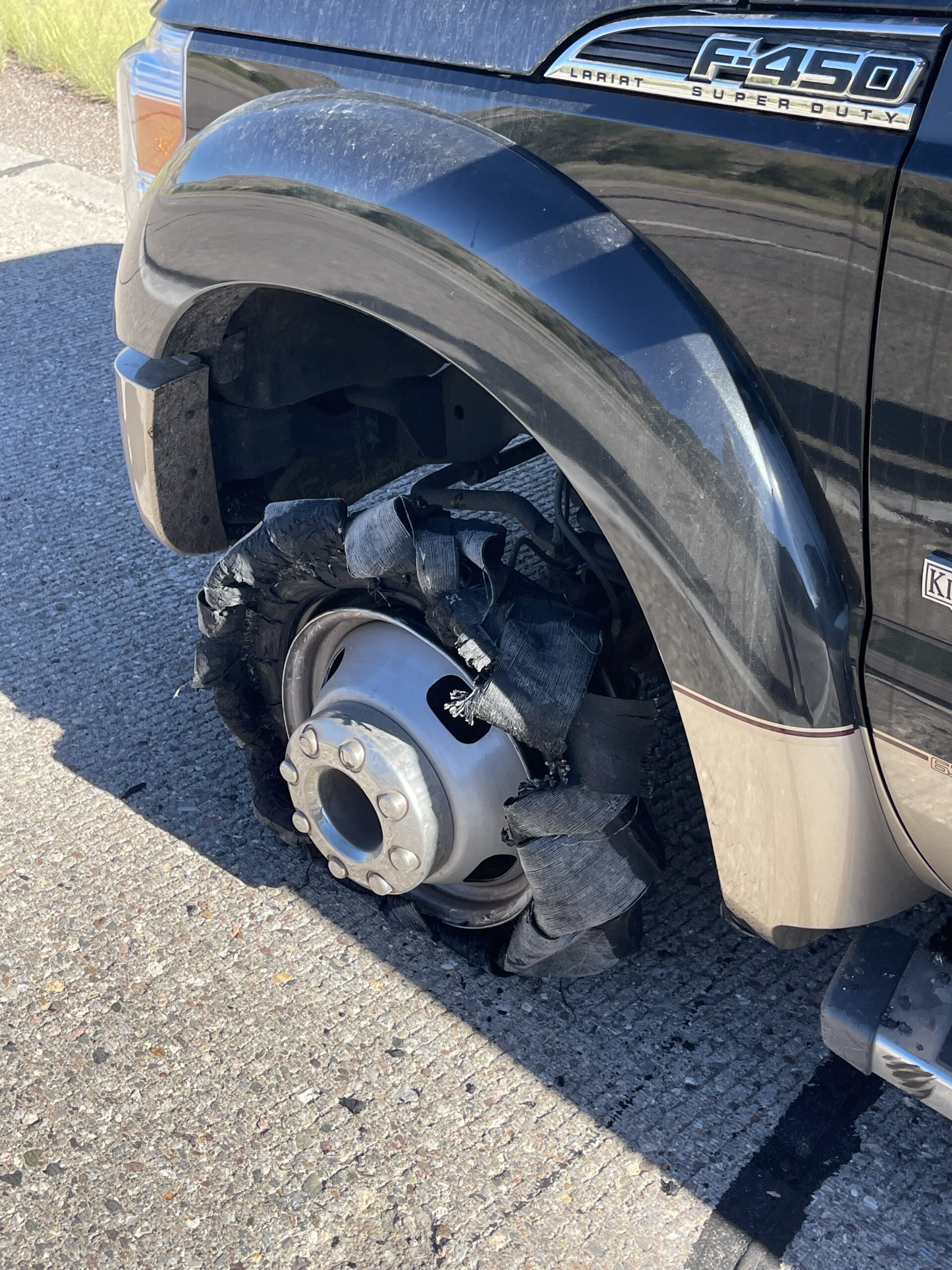 when two young boys, brothers in fact, were playing and one found a gun and accidentally shot the other. Oops!
And never a dull moment when it comes to travel. As I was on my way back to the campground from this trip, and while I happened to be in the passing lane of a highway attempting to overtake a tractor trailer, I all of a sudden lost steering control and had a terrible rumble in the front end of my truck. I let the 18-wheeler move on past me, along with another vehicle with a small trailer in tow, before safely moving off to the shoulder in the right hand side of the highway. I stepped out of the truck and found my left front tire totally blown apart – not just flat, but what seemed like blown into pieces and turned fully inside out. You may recall from a couple blogs ago that at the time I had no access to my spare. Well, as karma would have it, I still hadn’t addressed that issue and here I was again on this side of the road with a tire gone and no spare. Fortunately, my roadside service put me in touch with a company that had the size and type of tire that I needed, and they came out and did an on-the-spot tire replacement and got me back on my way. I think I’m going to not only address the spare issue, but I’m also thinking that it may be time to get my other four tires replaced soon. Ah, the fun that goes with travel!
 My next day of sightseeing would take me back to my youth in the mid 60s. As I was reviewing Roadside America to see what was around me to visit, there was a reference to a place about an hour north of me called the Rat Fink Museum. I had a familiarity with the term Rat Fink, but didn’t immediately recognize it fully. And this Roadside item was one of those with no pictures, so that didn’t help. I had to get on the web to look up the place to see what it was all about. As soon as I saw the pictures, I got a huge smile on my face, and I immediately turned 8 years old again. Rat Fink was a crazy monster mouse character found on lots of merchandise, mostly
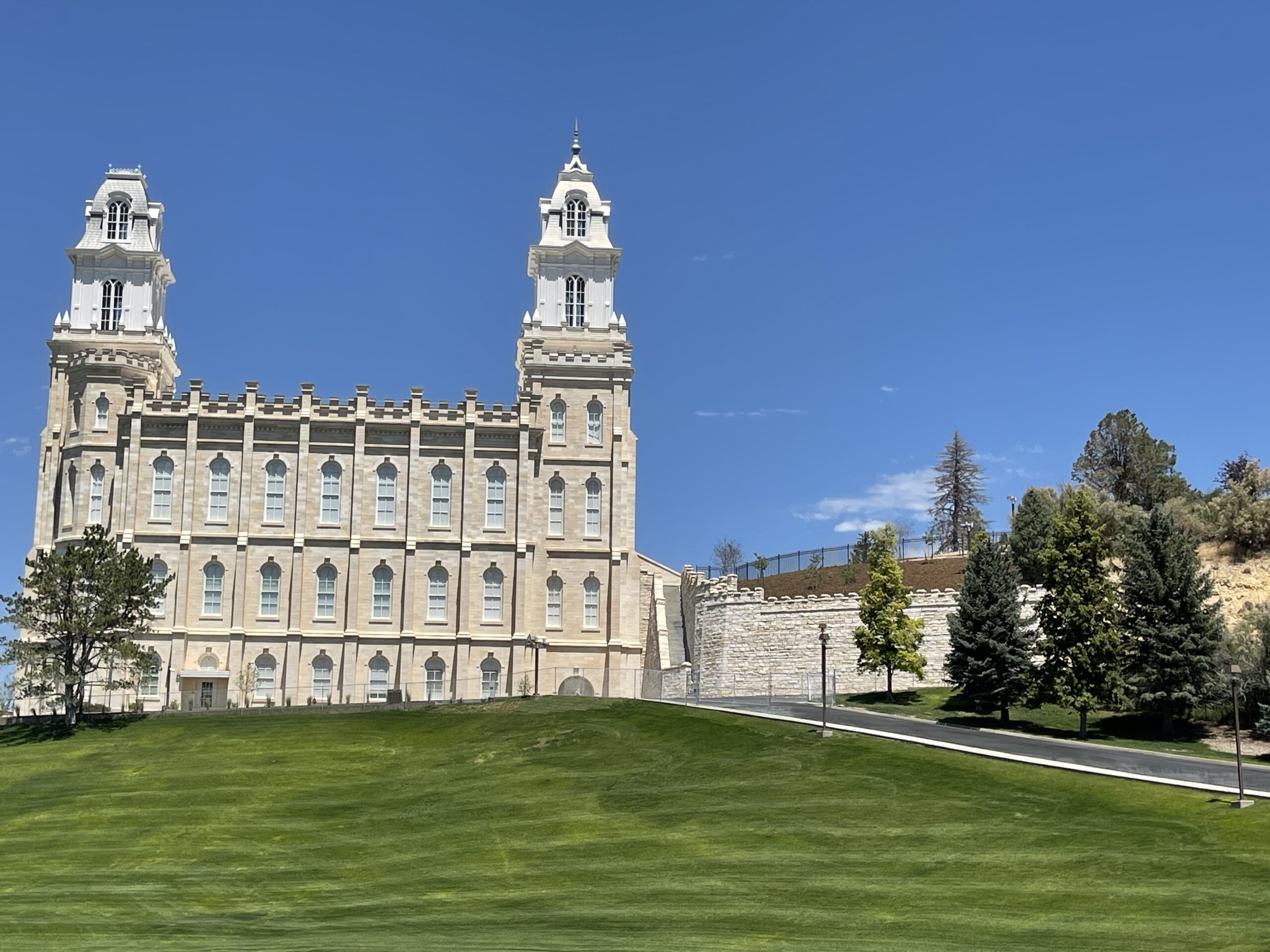
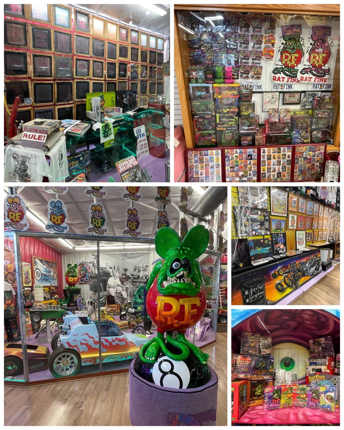 related to the hot rod scene. He would be on stickers, trading cards, and featured on models of crazy cars you could put together. I definitely remember building more than one of these cars from that series. It was Ed “Bid Daddy” Roth who was behind all this artwork, and this museum was his legacy. Ed passed away in 2001, and his wife and son have maintained a huge collection of his personal work and many of the products which feature his work into this amazing public display. I found it absolutely incredible just how prolific the Rat Fink brand actually was. Though it wasn’t a huge museum, I easily spent a couple of hours there wandering around checking out all the items, and reliving the memories of my youth (foggy as they may be). They even had a mock up of his working garage complete with the final piece he was working on at the time of his death. Ed was born in CA and spent most of his early life there going to school and designing, building, and painting cars. In addition to his work with cars, he was an artist, illustrator, and cartoonist. He built quite the following from the “Kustom Kulture” craze of southern CA. While in CA, he got involved with the LDS church, and eventually moved to Manti, UT, a small rural town with an amazing LDS Temple (pictured at the top of this blog), where he lived out the remainder of his life. This was a particularly fun visit for me as it took me back to something I’ve not thought about in many, many decades, and literally put a smile on my face reminiscing back to those times. Thanks Ed and family for the memories!
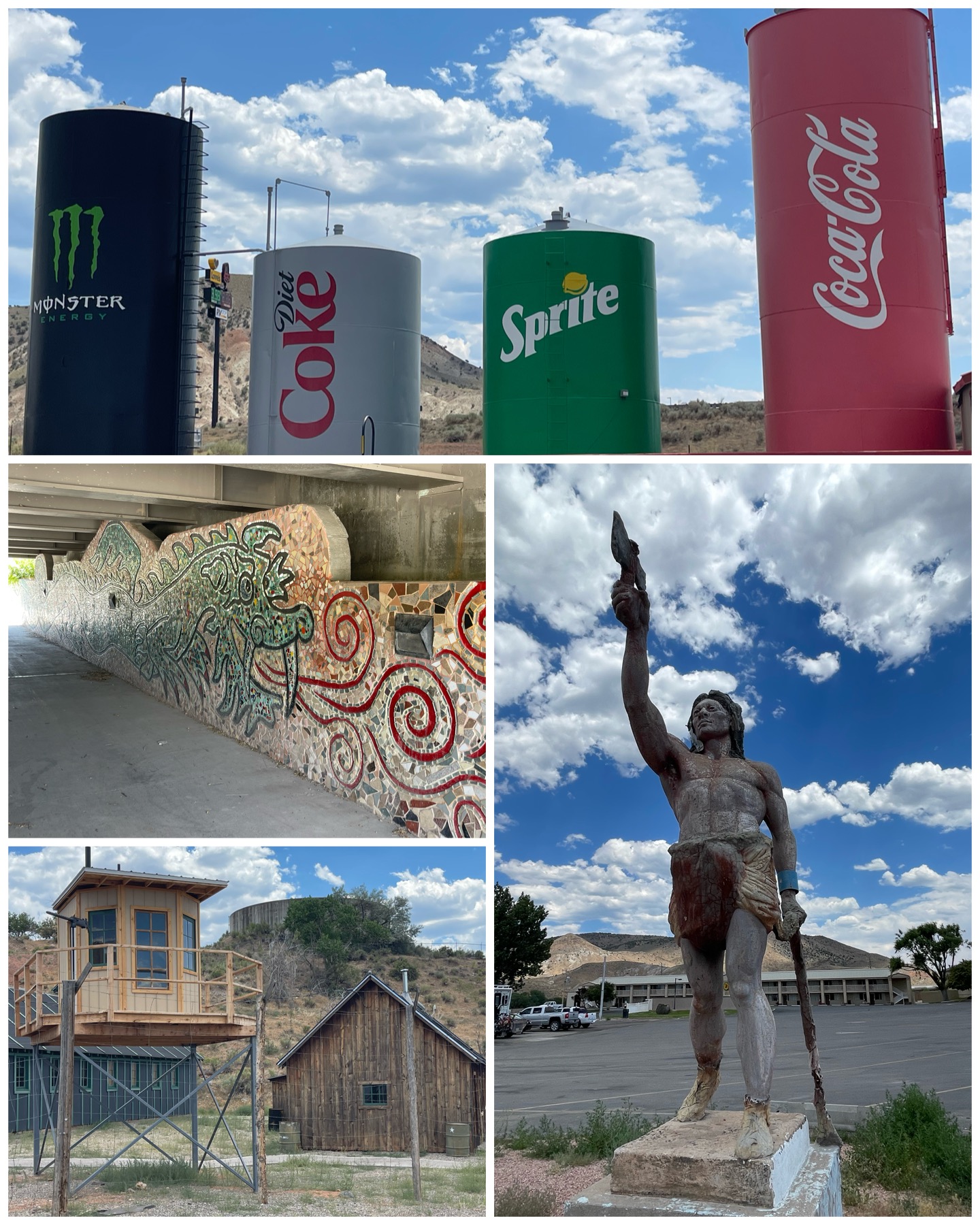 Next, on my way back from the museum, I made a few stops along the way to catch some other Roadside items of interest. First up in Gunnison, UT was this really cool dragon mural made out of tile (at left, center left). Located beneath a roadway overpass along a really nice bike trail was this dragon mosaic. Reportedly, the sounds of the cars passing overhead somehow resembles the roar of the dragon, but all I heard was car noise. Oh well! Next, I stopped in Salina, UT to check out a few more roadside oddities. There I found these presumed to be fuel tanks for a nearby filling station that have been painted to represent Coke products. Roadside also had pictures of them from many years ago when they were painted as Pepsi products. Somewhere along the way, they got swapped. Pretty cool. Within the same parking lot was this statue of what seems to be a Native American holding a tomahawk in one hand, and dragging a snake by the head in the other. Decades earlier, this statue was sort of a slave man wrapped in chains and holding what folks believed to be a milkshake. Apparently, the history of how it has transformed into the statue of today has been lost to time. Last up, I was to visit a rebuilt WWII POW Camp and museum dedicated to the Utah prisoner of war massacre. The story goes that back in 1945, Pvt Clarence Bertucci while on duty at the guard tower of this POW camp, loaded and fired a .30-caliber machine gun into the tents where the German prisoners were sleeping. With this senseless act, he killed 9 and injured 19 others. Bertucci was found to be mentally unbalanced and was sent to an insane asylum where he died some 20+ years later. Unfortunately, I arrived at the museum on a Monday when they were closed, so I was only able to get a pic from the outside. Once again, not doing a great job of checking my itinerary in advance of my sightseeing trips! Argh!
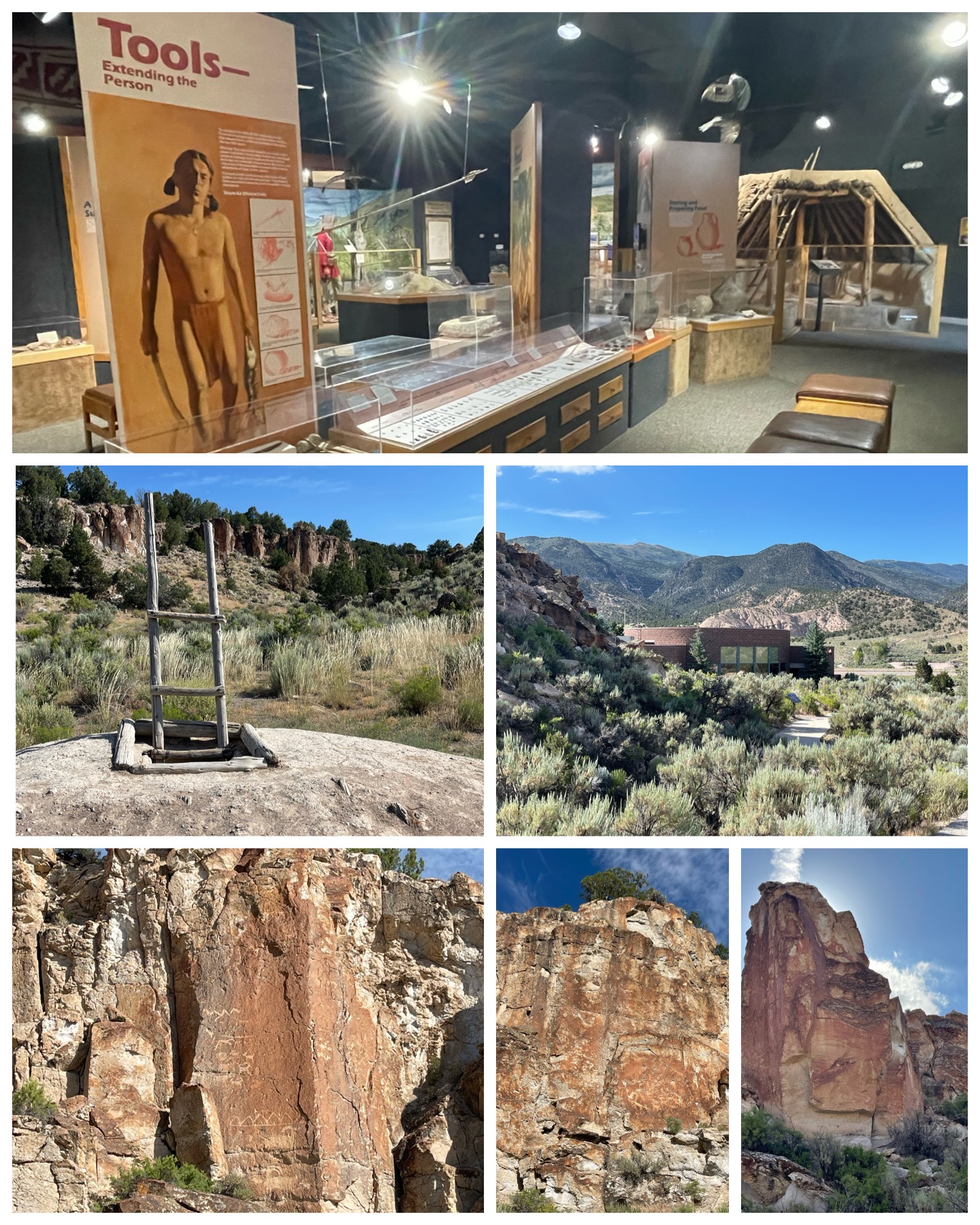 I spent my last day of playing tourist to head back southeast to pickup where I left off from the tire blowout. I wanted to check out the Fremont Indian State Park and Museum. In the early 1980s during the construction of I-70, earth movers uncovered some artifacts along the Clear Creek Canyon. Due to the landscape of the area and the narrow canyon, there was no way to change the flow and direction of this interstate. So, groups of archeologists were called in to quickly excavate the area to locate and preserve the pottery, tools, and weapons of what was believed to be from the Fremont Indians. This Utah state park was created and opened in 1987 to permanently house and display those artifacts found in the area, and to showcase the thousands of petroglyphs (rock carvings) and pictographs (rock paintings) found within the canyon. Also present is a reconstructed underground pithouse where the Fremont lived, and a granary storage room where supplies were stored. The Fremont culture were believed to have occupied this area for about 1,000 years from 400 to 1,400, and it remains a mystery as to why they left. Perhaps the carvings and paintings in the canyon provide some clues, but alas they’ve not yet figured them out. So, who knows!
Green River, UT
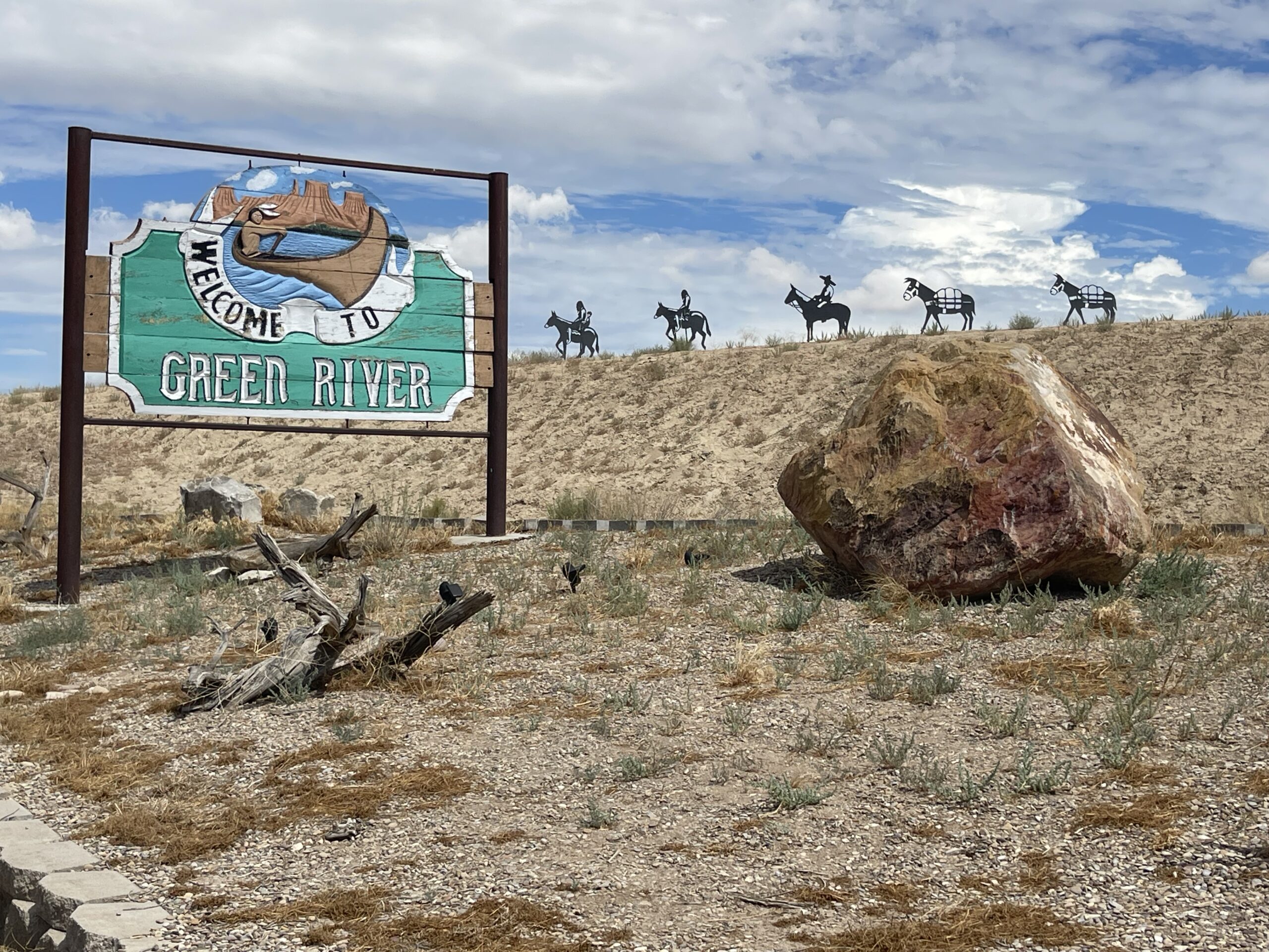 As a reminder, southern Utah is home to five national parks – known as the “Mighty Five”. I thoroughly enjoyed visiting the western parks of Bryce and Zion during my stay in Glendale. Next, I needed to find a town that was more to the southeast so that I could visit the three remaining parks situated there. On Google maps, the town of Green River seemed about central to that area, and with three parks to visit, I decided to book a two week stay here to provide enough free time to take it and all the surrounding area in. Well, I definitely did not do a lot of homework before finalizing this stay. Soon after arrival, I discovered that there’s really not much around here besides the parks. In fact, the lady who checked me into the campground was shocked that I was planning to stay for two weeks, and made it a point to ensure I was aware that there would be no refund if I were to leave early. That was my first clue! When I did some research on it later, I discovered that Green River itself is not exactly a booming town having a whopping population of 874 as of the 2020 census (and no, I did not miss a number or two in that population number – it really is just 874 people). It has just one grocery store, a handful of restaurants (mostly fast food), and no movie theater or other big name retailers. Not even a Walmart! Besides that, the nearest town having any appreciable size to it are 100 miles to the east (Grand Junction, CO), and 100 miles to the west (Salina, UT) on I-70. And, related to that aforementioned Walmart, the closest one from here is over 80 miles away! So besides the park visits, it looks like I’ll be doing some chilling for the next couple of weeks in this one horse town. But on a positive note, I have screaming fast Internet from my new T-Mobile 5G service, so that’s definitely a plus
 While figuring out my national park visits a few weeks back, I discovered that Arches National Park requires an entry pass in order to get in. The passes are timed and good for a one hour entry window, and a limited number of them are available for each peak hour of each day. This is done to manage and control the number of vehicles that enter the park during peak times (basically 7am to 4pm), thus preventing a rush of folks showing up at the same time. Having experienced way too many people at Zion National Park, I can certainly appreciate this system to keep things manageable and enjoyable. So several weeks before my travel to the area, I had booked an 11 am pass for the Friday after my arrival. I got to the entrance gate a bit before 11 figuring there would be a line of cars, and as predicted, there were. But it went fairly quickly, and I got in about 11:20. I hit the visitor center first, got my park book stamped, watched an introductory video, then off I went driving along the roughly 20 mile sightseeing road with lots of scenic stops along the way. The entry system seems to work as there was not a lot of traffic on the roads, and I had no trouble finding a parking place at either the visitor center, or at any of the scenic stops along the way. So kudos to Arches for having a terrific system that works! At each of the stops it was, like many of the national parks that I visited prior, just one amazing and wondrous view after the other. Through natural erosion from wind and rain, walls of sandstone are formed into various shapes – many having holes bored through them forming windows and through continued erosion, will oftentimes develop into arches. There are over 2,000 arches total in the park – many of which are remote. I was unwilling to take several hikes of many miles each in 110+ degree heat, so I
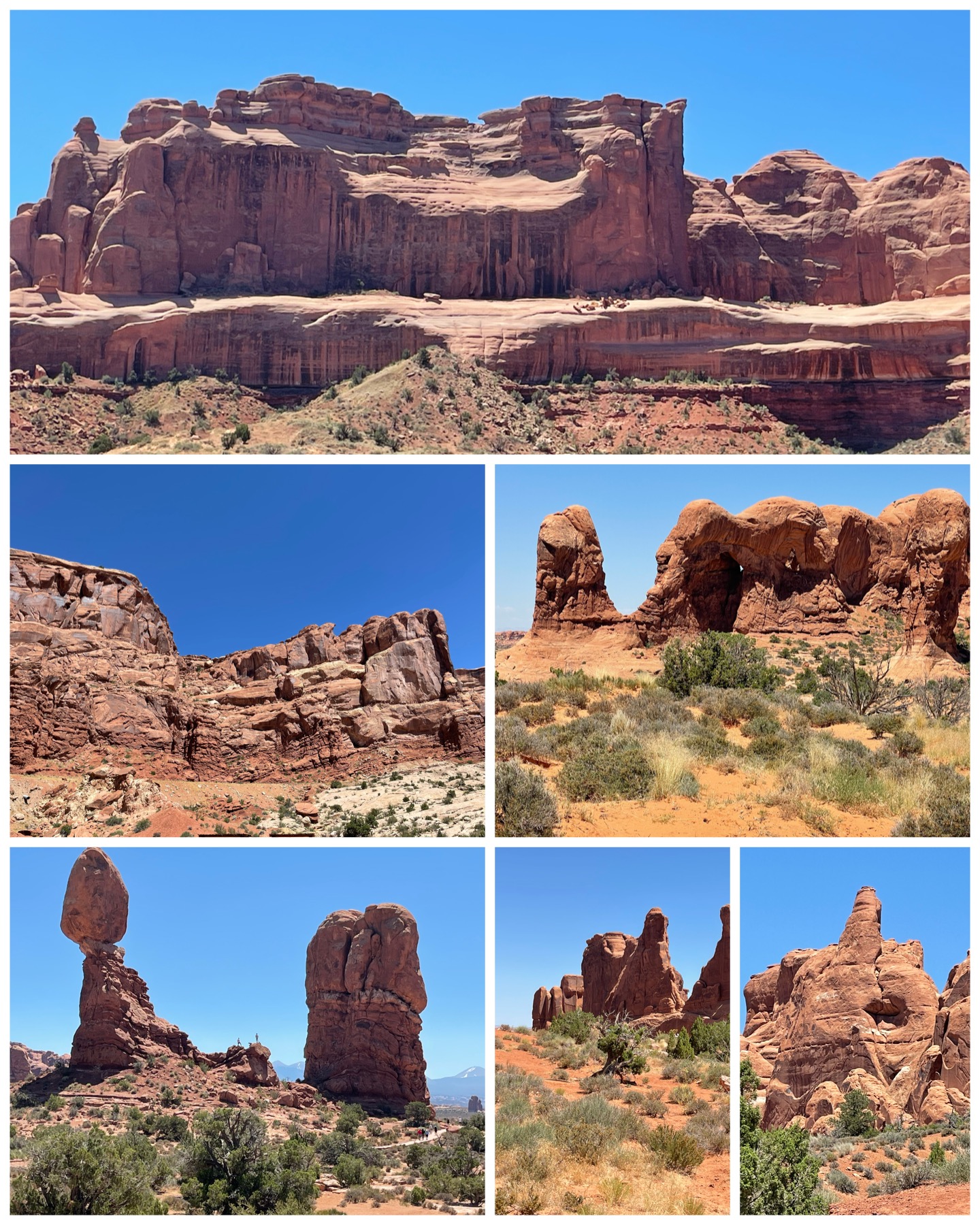 only really got to see a handful of arches that were visible from the scenic road stops. But that was perfectly fine with me, and for the ones that I saw, they were spectacular! There was one in particular, the Sand Dune Arch (at left, top left), that I did take a short half mile hike to visit. It was a fun walk on red beach-like sand through narrow canyon walls with an occasional small rock climb along the way, to arrive at this beautiful naturally crafted arch. I also got to see one of the more well known arches, Delicate Arch (at left, center right), though from the vantage point of a scenic overlook from across a canyon. It was stunning!
Arches is over 76k acres, or approximately 120 square miles in size, and welcomes just shy of 2 million visitors per year. It was originally named a national monument in 1929, but later redesignated as a national park in 1971. And for the record, not everything in the park are arches. There were tons of other amazing sandstone structures and anomalies to gaze at. This included multi-tiered stadiums, and lots of interesting natural carvings like a rock on a post (at right, bottom left). I especially enjoyed what I like to call the “FU” monument (at right, bottom right) that resembles a hand seemingly flipping the bird. However, I don’t believe the National Park Service shares my interpretation of this archeological structure. Oh well! But all in all, another amazing national treasure that should be visited by everyone. Here’s a short drive through video that gives a better view of this magnificent national park.
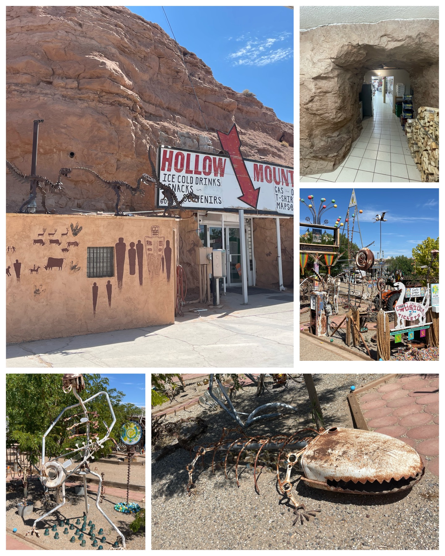 Next, it was time to hit a couple of Roadside places on the way to my next national park. First up was a visit to the Hollow Mountain Gas & Grocery. Located at the corner of Rt 24 and Rt 95 in Hanksville, UT this place has been a local attraction for upwards of 40 years. Though hardly a mountain, this 60 foot tall rock was blasted out back in 1984 to make way for a gas station and convenience store. Someone got the bright idea instead of blasting the entire rock away, burrow into it and put the convenience store inside the rock. It was definitely kinda cool. When you first walk inside the store, you really don’t know you are inside a rock as it has normal walls and a drop down ceiling. But if you walk to the back of the store, you can see the exposed rock and even the drilling marks left from where the rock was fractured. Very cool indeed! Just down the street from the gas station was Carl’s Critter Garden. Booming with a collection of basically junk art, this garden features lots of scrap metal creatures – including a skeleton playing a guitar, and a skeletal aligator. All these art pieces sit along the roadside in front of a long since abandoned hotel. Certainly an interesting stop.
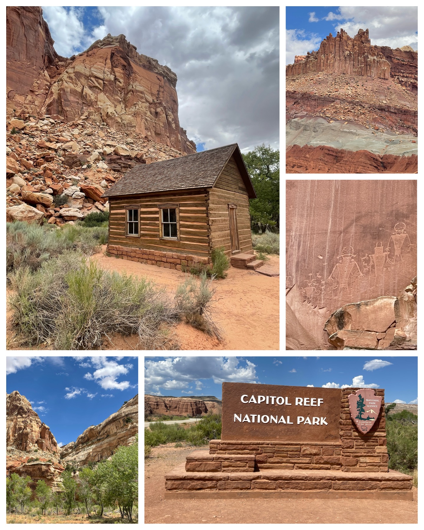 Next I visited my fourth of the Mighty Five national parks in Utah – namely Capital Reef National Park. First known as “Wayne Wonderland” in the 1920s (due to its proximity to Wayne County, UT), the area was designated as a national monument in 1937 by President Franklin D Roosevelt, but was not officially open to the public until 1950. In 1971, it received its national park status. This park sets out to preserve a 241k acre, or 377 square mile area filled with colorful canyons, ridges, buttes, and monoliths. It also happens to include the once occupied town of Fruita – a Mormon settlement from the late 1800s. The original school house (at right, top left) is one of only a few buildings that remain. Apple orchards that once served the settlement also remain and are now managed by the NPS. Besides the ever present beauty of these canyon-filled landscapes, one of the more interesting features of this park were the petroglyphs (at right, center right), believed to have been carved into the sandstone rock walls by ancient Fremont and Ancestral Puebloan people between 600-1300 A.D. The true meanings of these stories are not known, but to my untrained eye, they surely seem to suggest these ancient people were documenting visits by aliens. What do you think?
One of the cool things about Apple Photos is its automated feature that creates these various little videos called “For You Memories”. It might create a video montage of a particular person, or it might be a collection from a days adventure. I happened to notice it created one titled Capital Reef from my travels that day, and it really turned out great. So much so that I decided to save it and share it here for your viewing pleasure. Enjoy!
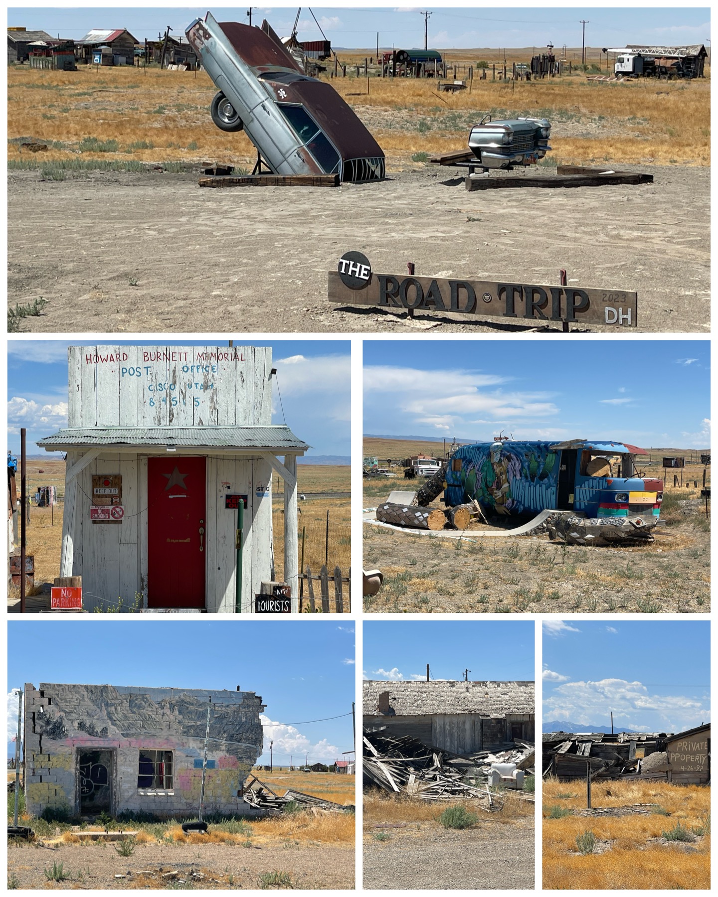 My next tourist travel day would take me east a ways, then south towards Moab to take in a bunch of Roadside stops. First was a visit to the town of Cisco and its designation as a ghost town. It was located approximately 50 miles east of my location in Green River just off of I-70 – or about half way to the next populated town of Grand Junction, CO. Back in the day Cisco was a water refilling station and stopover along the Denver and Rio Grande Western Railroad. Nearby cattle ranchers and local miners used Cisco as their provisioning center. Many travelers came through which resulted in stores, hotels, restaurants, and even a saloon to be built in this once thriving town. But like many other rural western railroad towns already in decline, the death knell was when I-70 was built, bypassing Cisco altogether. Today, all that remains are mostly the decaying remnants of a once thriving town. But there is some interesting history here. The movies Vanishing Point, Thelma and Louise, and Pontiac Moon were all filmed here in Cisco. Also, the remnants of the Cisco Clifton Filling Station (at left, bottom
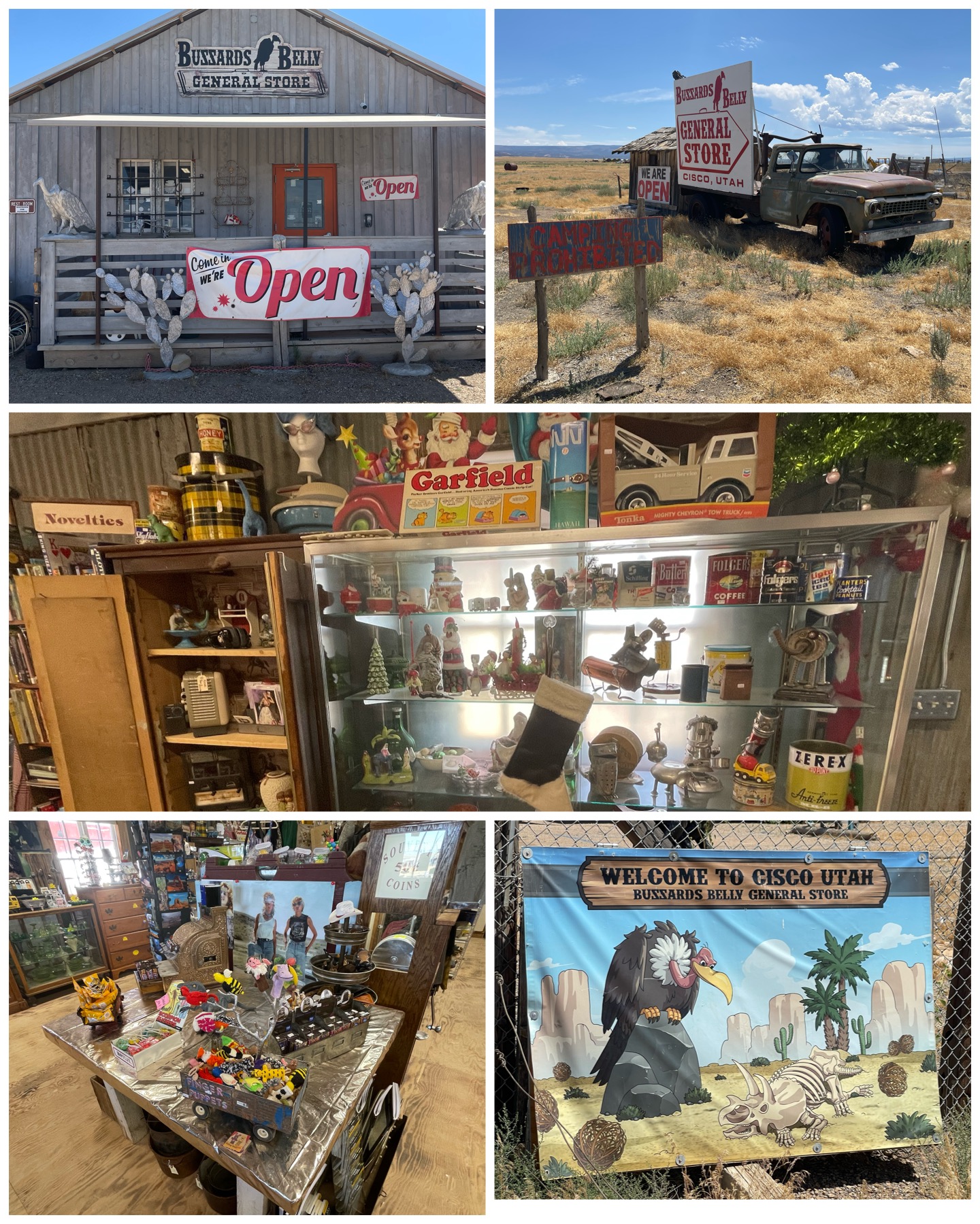 left) was the basis of the 1968 Johnny Cash song of the same name. You can listen to and watch Johnny perform this iconic song HERE.
Cisco’s designation as a ghost town is not totally accurate though. There are actually four people who reside in this obscure town. One nice woman who I met and chatted with for a bit is the proprietor of the seemingly only function business in town – the Buzzards Belly General Store. It was more of a combo grocery and antique goods that actually made up the contents of the store. I jokingly said to the store owner that having only four permanent residents, you must rely heavily on tourist to come patronize your business in order to say afloat. She chuckled and confirmed my suspicion. In fact, just during the roughly 30 minutes or so that I was there, a dozen other tourists also stopped by for a visit. I bought a drink and snack to do my share, and moved on from this very interesting little town in the middle of nowhere.
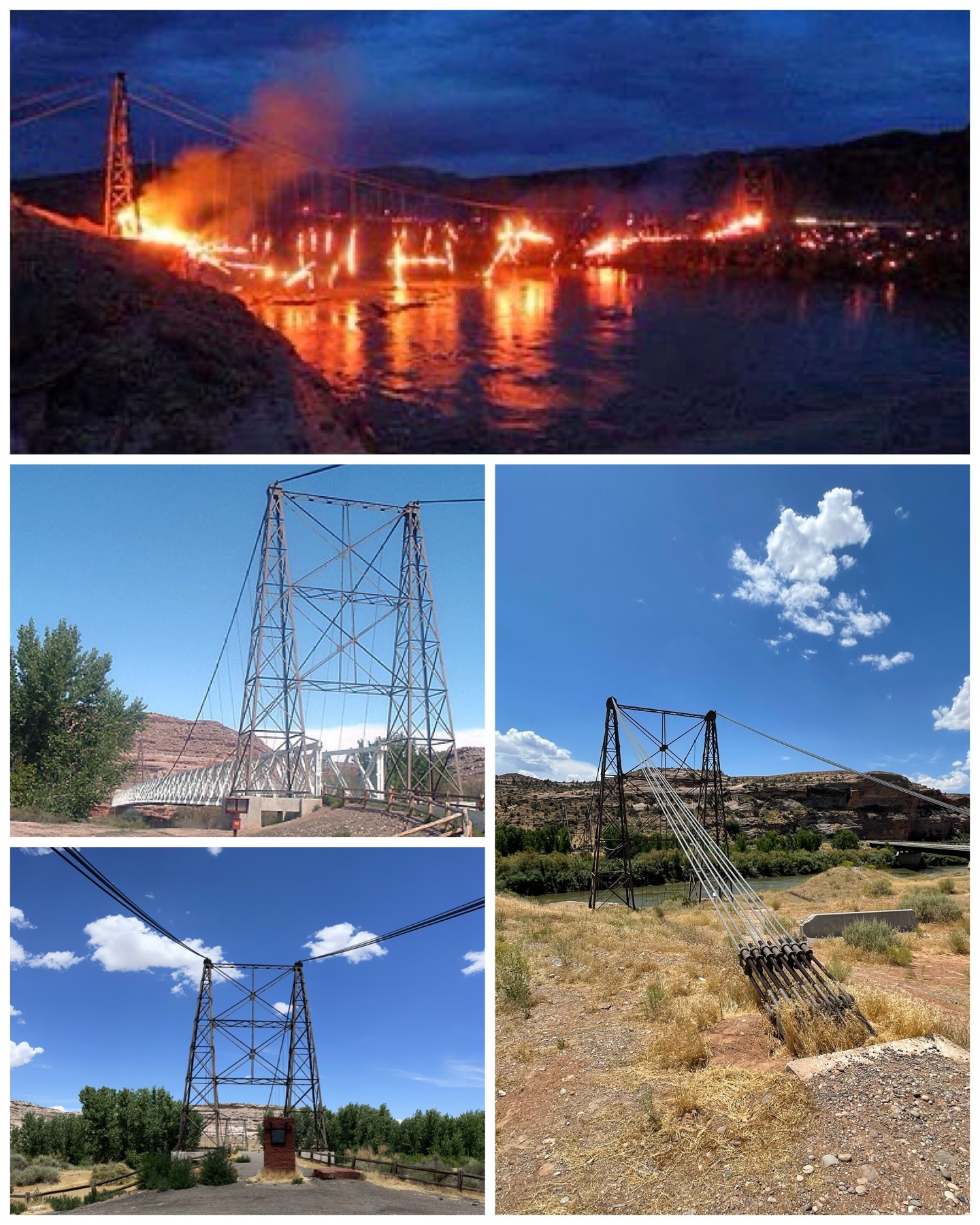 Next, I headed south towards Moab, UT to take in a few more Roadside stops. First up was a visit to the Dewey Suspension Bridge. This bridge has an interesting history. Crossing over the Colorado River, this bridge was built between 1915-1916, and was the longest suspension bridge in Utah at 502 feet long. It had an 8 foot wide wooden deck that was engineered to support the weight of 6 horses, 3 wagons, and 9,000 pounds of cargo. Also, it was the 2nd longest suspension bridge west of the Mississippi. A new and updated bridge was built in 1988 just up river from this one to support more modern day traffic. A restoration of the old suspension bridge was completed in 2000, at which time it became part of the Kokopelli Trail for bicycle and pedestrian use. Sadly, on Apr 6, 2008, a 10 year old boy who was camping with his family in the area was left unsupervised and playing with matches near the bridge. He started a brush fire, which quickly spread to and totally destroyed the wooden bridge deck. The steel suspension and other structural components are all that are left, and all that I got to see (at left, bottom). Online, I found a couple more pictures – one just after it had been beautifully restored (at left, center left), and one that was taken during the tragic fire (at left, top). In 2009, a fund raising program was started to pay for a feasibility study to determine restoration options. It was estimated to cost just shy of $1m for it to be restored. Its been 15 years now since the loss of the bridge, and it would appear the necessary fund raising to complete the restoration have long since stalled. Such a sad loss! Hopefully someday, funding can be obtained, and this bridge can be restored to its old glory days.
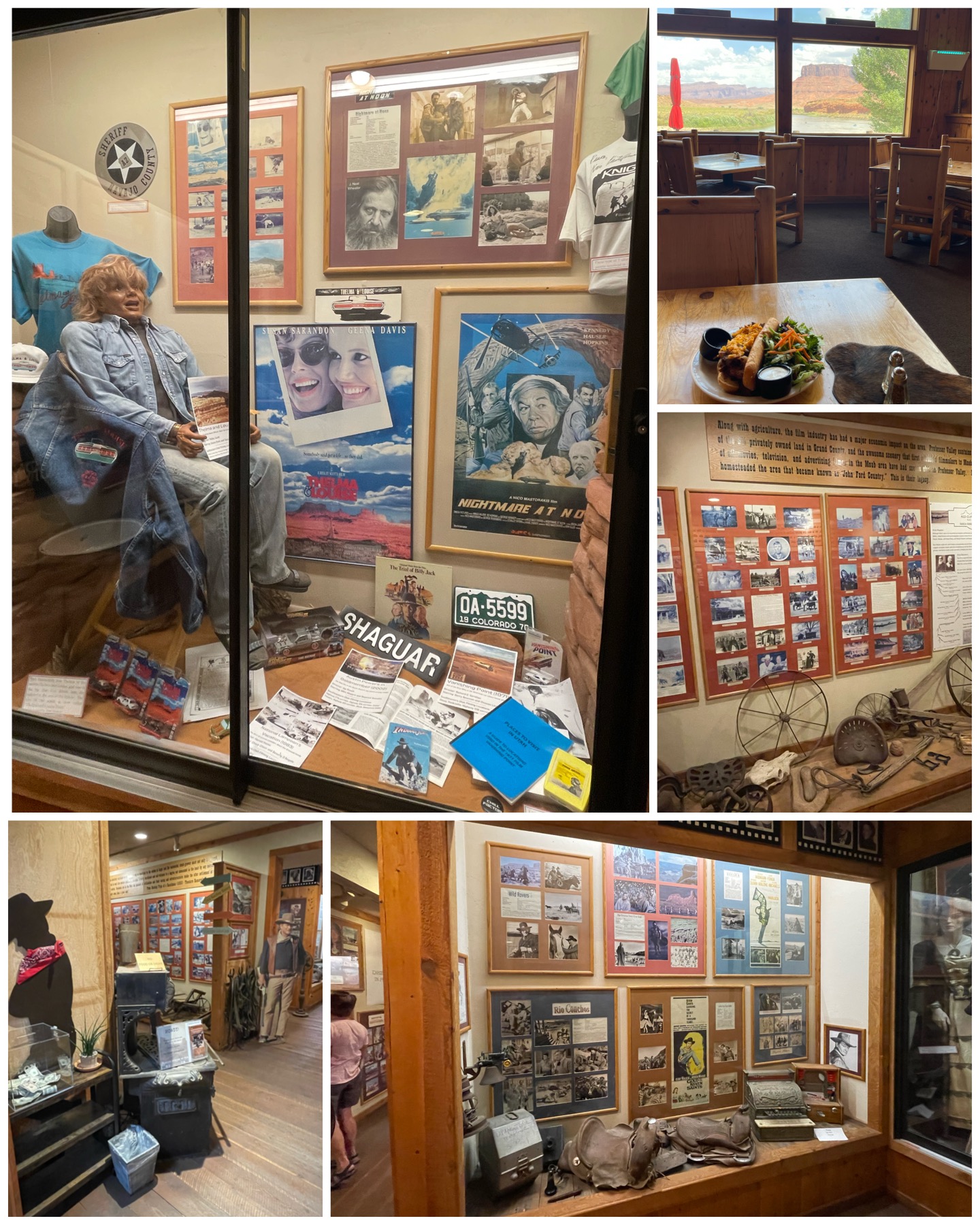 My last visit for the day would take me to the beautiful red cliffs of Moab, to the Red Cliffs Lodge. There I would take a welcome break for lunch – one with a spectacular view (at right, top right). Then, I would pay a visit to the Moab Museum of Film – located in the lower level of the lodge. This museum pays homage to America’s Western Heritage as showcased by movies made in southeastern Utah. In fact, over 120 movies, and hundreds more TV series, specials, and commercials have been filmed in the Moab-Monument Valley area. Listed among its movie credits started with the film The Vanishing American from 1925, thru the movie Need for Speed filmed in 2013. On display are movie posters, backstage production photos, autographed movie scripts, and props from the many pictures filmed in the area. Perhaps most notable among the props on display is the life-like mannequin dummy from the Susan Sarandon & Geena Davis film Thelma & Louise. The dummy was used in the legendary over the cliff scene at the end of the movie – which if you are interested, you can watch HERE. In fact, there is place called Thelma & Louise Point which is where this scene was filmed. Sadly, a high-clearance 4 wheel drive truck is recommended to visit the actual spot. Though my truck mostly qualifies, I decided not to put it through the rigors of that trip. Overall, I was amazed at the number of films, many most notable ones, that were filmed in this area. But then again, with the beautiful red sandstone canyons and the meandering Colorado River, it certainly makes for an amazing movie backdrop.
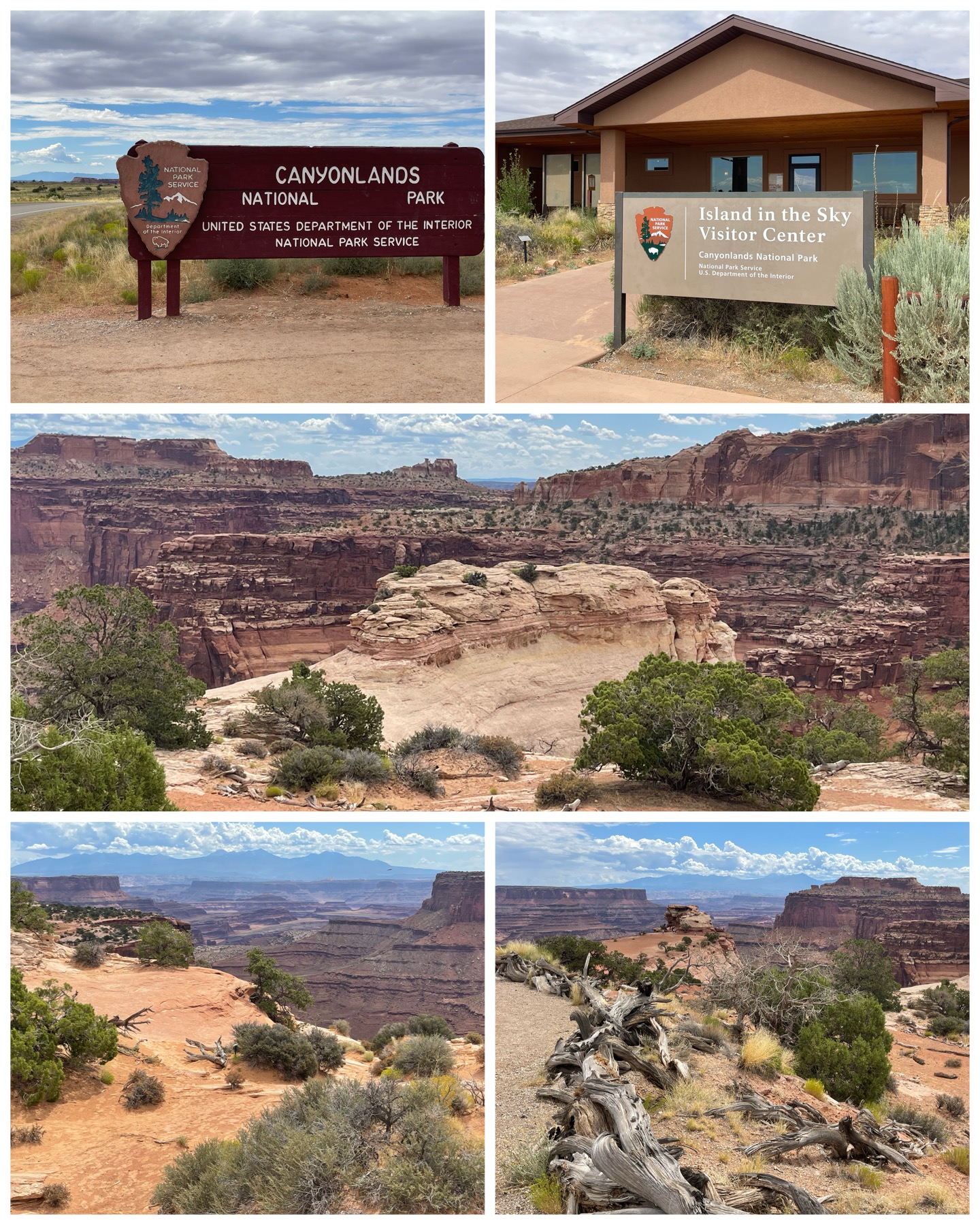 Next, it was back to the national park trail to wrap up the tour of the Mighty Five. Canyonland National Park was my last and final target of the group and, like all the southern Utah national parks before it, the scenery was simply spectacular! I arrived at the northern visitor center known as the Island in the Sky after about a 20 mile ride on scenic canyon road Rt 313. From there it’s a 12 mile scenic drive along Grand View Point Rd where it dead ends at, what else, Grand View Point. There were many stops along the way to include Shafer Canyon, Candlestick Tower, Buck Canyon, the Orange Cliffs, all leading up to the Grand View. To simply say the views were magnificent seems understated. You
 really have to see this place for yourself to truly appreciate its beauty.
Canyonlands was established as a National Park in 1964 by President Lyndon B. Johnson and coveres over 330,000 acres. The Colorado and Green Rivers divide the park into three distinct areas – the Island in the Sky, the Needles, and the Maze. The Island in the Sky is the most accessible portion and hosts upwards of 400,000 to 700,000 visitors per year – representing approximately 80% of all visitors. Needles is generally only accessible along its primitive dirt roads using 4WD or ATV type vehicles, and generally sees the other 20% of visitors. The Maze region sees little visitor traffic as it has no roadways whatsoever, so visiting that area requires hiking in or via the river. Speaking of the river, rafting and kayaking is a popular activity through the canyons. South of where the Colorado and Green rivers meet, known as the Confluence, offers some of the largest whitewater in North America. Something I’ll leave to the younger crowd!
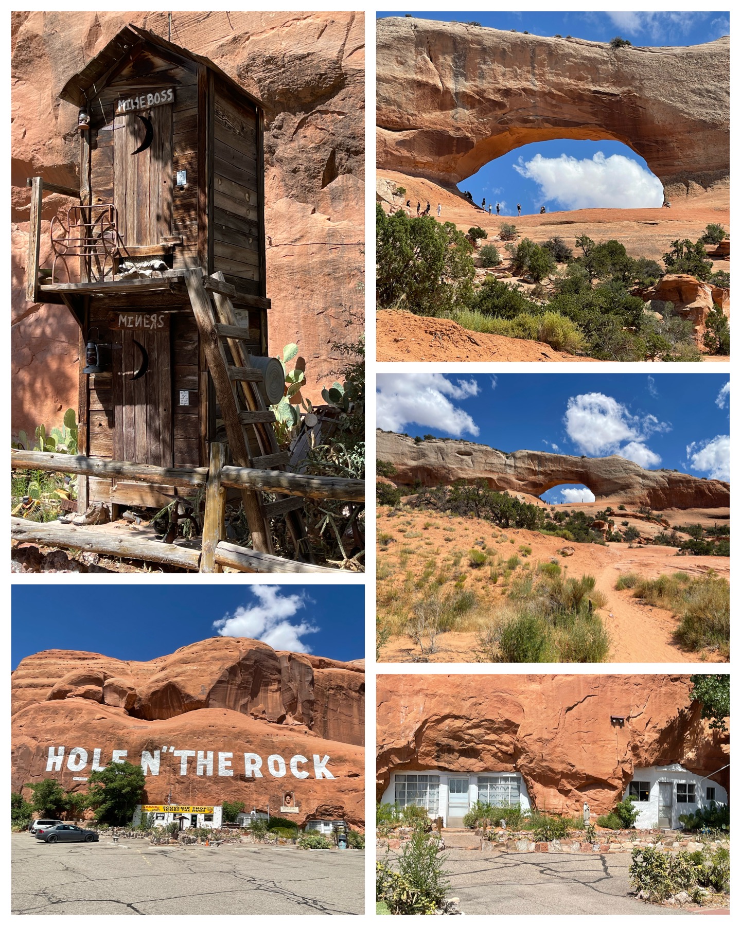 After my visit to Canyonlands, I chases after a few Roadside America sites south of Moab. First up was a visit to yet another hole in the wall place. Similar to the gas station convenience store in the rock I visited earlier, this place was much more extensive. Besides having a gift store built into the side of a large mountain rock, there is an extensive residence and diner built there as well. The brainchild of Albert Christensen, he drilled and blasted this rock for 12 years beginning in the 1940s to build his luxurious 5,000 square foot home with 14 rooms including a cavernous bathroom referred to as a “toilet in a tomb”. He called this creation his Hole N’ The Rock. After moving into the cave residence in 1952, Albert and his wife operated a diner located in one of the rooms until Albert’s death in 1957. His wife Gladys lived for 17 additional years and operated a cafe and gift shop. Tours of the inside were offered, but expensive and they strictly prohibited pictures or videos. So, since I could not share what was inside, I opted to pass. They did have lots of other interesting things within the grounds of the place including a convenience store, a kids play area, and even this really unique double-decker outhouse where the Minor Boss uses the top, while the lower level worker-bee Minors use the bottom. I’m not exactly sure how that is supposed to work, but it certainly was interesting. I also visited a really beautiful roadside geological formation known as the Wilson Arch. It sits right on the side of highway 191 just south of Moab, and appears to be a frequent playground to tourists and locals. It was a fairly short, yet very steep climb up to the arch that many folks enjoyed to get an up close and personal look.
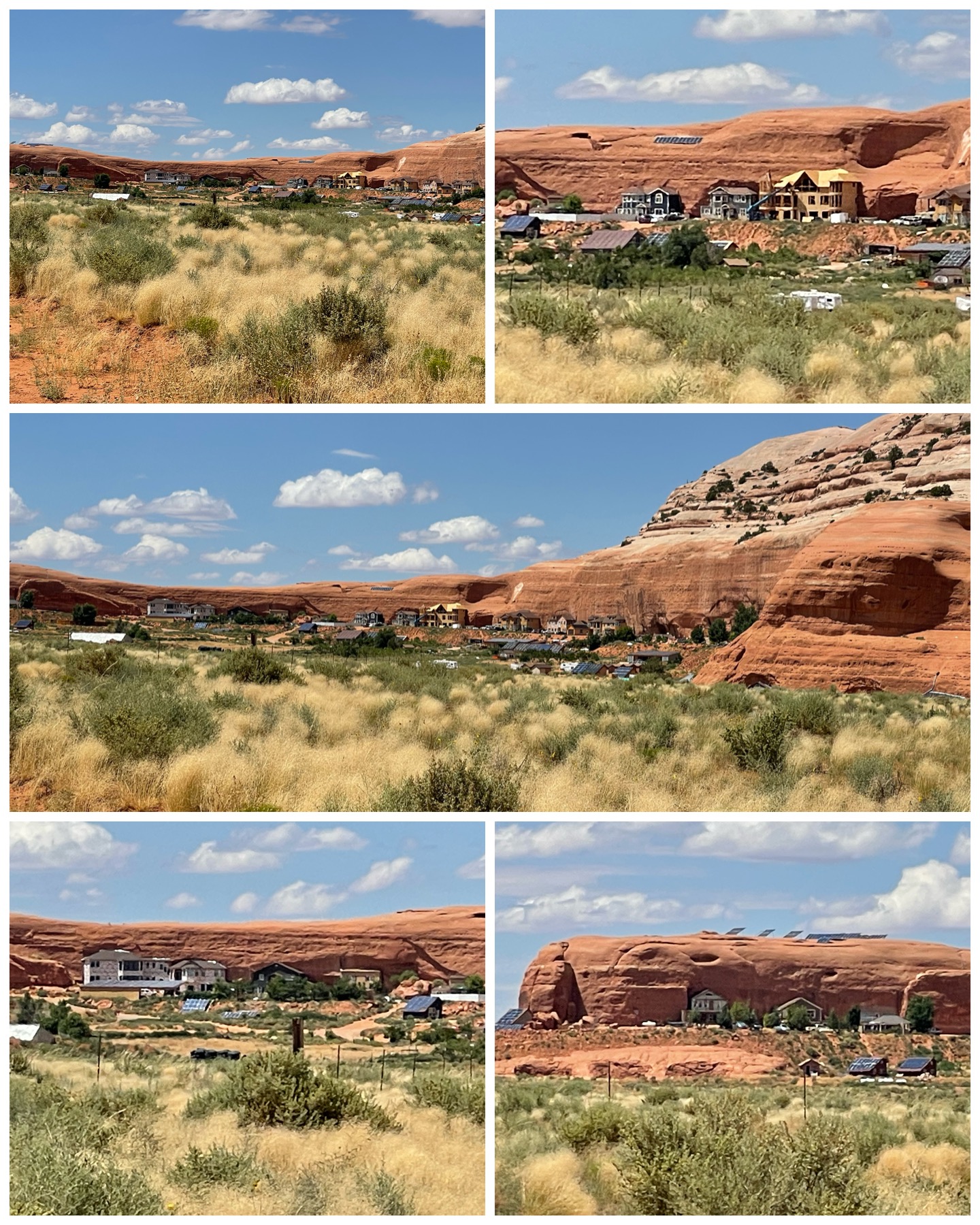 My last tourist activity would take me to Rockland Ranch. This was perhaps the most difficult site I’ve ever had to get to, and surely is not for the faint of heart. It’s a 9 mile ride along a narrow washboard dirt road with rocks and potholes everywhere, and even a trip down through a canyon wash, to get to the final destination. I decided not to drive fully into the community, but rather stay a respectful half mile distance away. There are two things which make this community interesting. First, many of the houses are built into the rock wall (seems to be a thing here in Utah), with only the front portion facing out exposed. Second, the community is occupied by fundamentalist Mormons who practice polygamy. Formed in 1977 by Robert Foster, it was deemed a place for them to live and practice plural marriage out of the public eye. Well, given the extreme drive needed to get there, I would certainly say they are successful in mostly staying out of the public eye. After learning about this place, I found there was a 4-part docuseries produced back in 2017 that featured stories about this community and its residents called “Three Wives One Husband” (available on YouTube). So before my visit, I watched all four episodes to get a better understanding of the community and the residents who live there. It was very interesting, and I certainly have lots of respect for the men who seemingly manage to keep several woman happy at the same time. They must be exhausted! From what I saw from the 2017 series and what I saw in person there at the community, there seems to be several more houses built, and a couple of mega mansions currently under construction. So, polygamy must be thriving! Anyway, it was a cool visit seeing this unique community, and definitely worth the crazy drive to get there.
Blog Updates
 In addition to writing this edition of the blog, I’ve also been busy with a few overall updates to other content in the blog. The section titled “Fun Facts” has been updated through Jul 2023 in all the slides. I also installed a new widget that you can see at the upper right under the heading “Archives”. Before, it was merely a running list from each month that I’ve been publishing, and the list was really getting long and out of control. So I looked for something that would collapse all that info by year and month so that it wouldn’t be so long. I found such a plugin from a developer in Cúcuta, Colombia, and it was a fairly easy install and customization to get it looking the way I wanted. I hope you all will find it more useful than what was there before.
Final Thoughts
 Wow, this blog is certainly filled with lots of content, but then again, between all the national parks and the other interesting places to visit, there was a lot to write about. I have absolutely and thoroughly enjoyed my whirlwind visit to southern Utah, and can finally check off several more national parks from my bucket list. Next I head north to the Utah state capital – Salt Lake City. There will be lots of places to explore there, as well as the pleasure of meeting up with some former coworkers. This will also be my last extended stay for a week or more, after which I’ll be making rapid 2 and 3 day hops for the next 8 stops getting me through WY, NE, IA, and IL as I begin my eastward trek towards New England. I won’t have another week long stay until the beginning of Sep when I arrive in Indiana. So I predict the month of Aug is going to fly bye quickly. But, I’ll certainly be making the best of it taking in some sites along the way. Until next time, be well and safe travels!
I only show a sampling of my adventure pictures here in the blog, and do so mostly in collage format for brevity and ease of reading. If you want to view an album containing individual full fidelity and hi-res images of all my travel pictures related to this specific blog, click the image below. Enjoy!

Utah sure has some great things to see. You are lucky your tire blowout did not cause a crash. That tire sure disappeared. Safe travels on the rest of your trip.
Yea, so much to see in this area for sure. The next time you take a trip to Washington, you should definitely plan to spend a little time around here on your route. The tire blow out was surely scary, and I’m thankful I didn’t crash.
Great blog as usual – busy, busy you are!! Looks amazing!
Continued safe travels and fun!!
Thanks MG! Yea, I’ve been staying rather busy lately. So much to see, and limited time. I have to make the best of it.
Thank you for sharing your journey. I am glad you have a good support team to replace your tire on the spot – no towing needed. Now figure out how to access your spare! Safe Travels. I was able to visit the Lawrence Livermore Nuclear Lab Discovery Center in Livermore, CA – it was easy to get to – right inside the gate of the campus, with no need to actually go through the security gate. A small museum with a lot of information about what the lab does on their campus – displays about climate control, the ventilator the Lab made for the COVID-19 pandemic, a science based trivia game and videos about 3d printing and much more – all free.
Yea I was thrilled that I didn’t have to get towed. Such a better and quicker outcome. I think I’ve addressed the spare issue. More details in the next blog. I’m glad you made it to the lab for a visit. Sounds like a great stop. Continued good travels to you.
Great blog Bruce! Places I’ve yet to visit. You’re
Making it easy for me to decide where I’ll start.
I wish you no more tire mishaps only safe driving.
Thanks Theresa! The west would certainly be a perfect start for you in your travels. So many beautiful places to see out here. So get some planning done and hit the road as soon as you can.
Interesting as always. I love how you mix major National Parks with little known places way off the grid. A nice combination that gives you a better perspective of what this country is all about. You cover it all! Now get that spare positioned so that you can actually use it. Safe travels.
I agree – I enjoy going to the popular tourist spots, but I also love to check out the more obscure places to visit too. It is a nice balance. Touristy places can often be crowded, while obscure places not so much. As for the spare, I think I got it resolved. Details in the next blog. 😁
Great stories Bruce and the pictures are amazing. Please take the time to get access to your spare tire as you always seem to need it on your trips. Be safe and I look forward to the next blog.
Thanks for the kudos. All the pictures are taken with my iPhone. It sure seems to capture a nice scene. As for the spare, I think I’ve got it resolved. More info to come in the next blog.