Yea, ok I know this is a cliché. But c’mone, it’s “standin’ on the corner in Winslow Arizona”. It was such a fine sight to see, I just had to do it! I had a wonderful two weeks here up in the mountains of northern AZ. I got to check off a couple more National Parks, got to play on Rt 66, and enjoy some of the most spectacular weather I’m likely gonna see for a while. So, let’s dig in to what I’ve been up to the past two weeks.
Holbrook, AZ
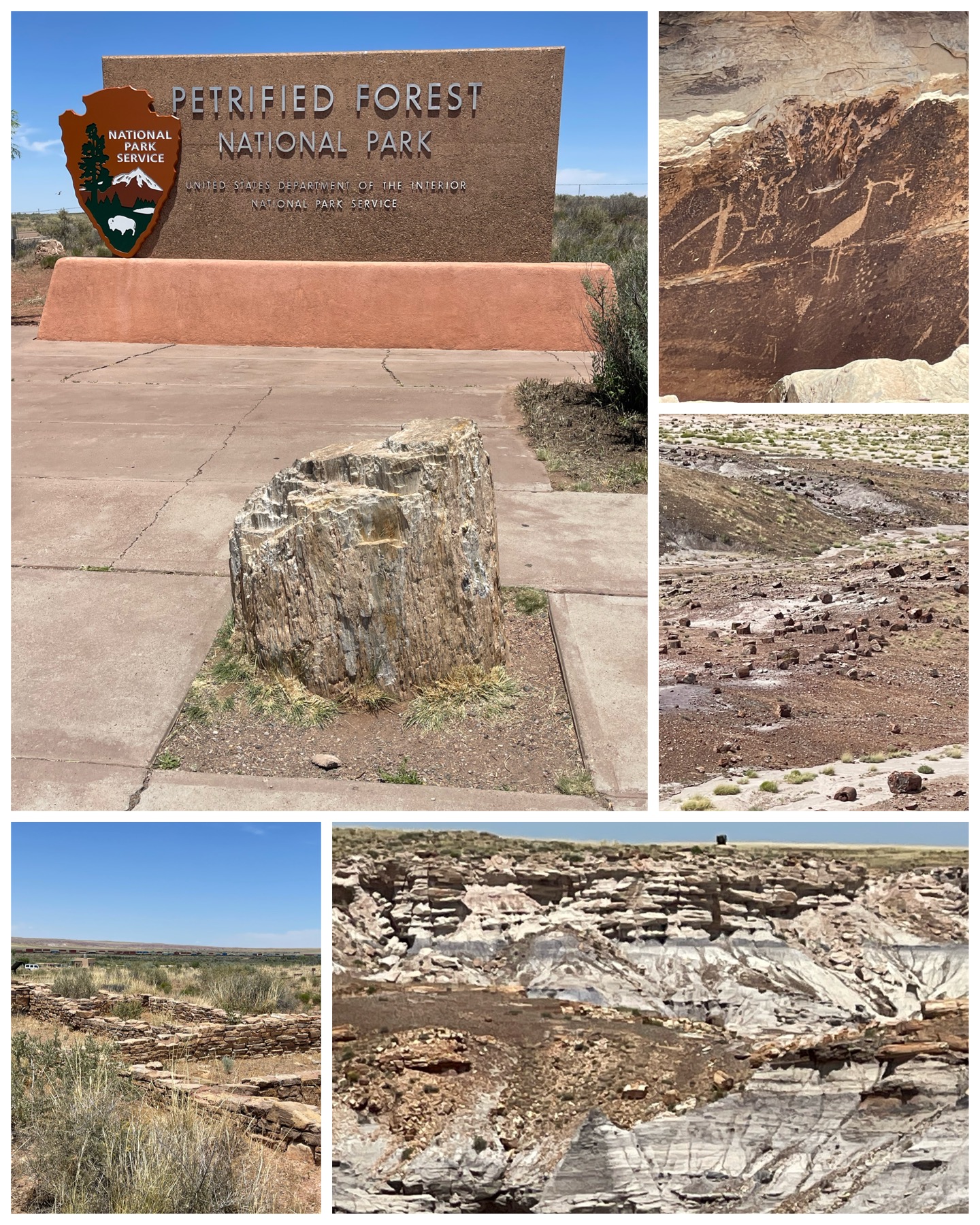 Holbrook turned out to be a really cool place to visit, and from which to take several day trips in various directions for other touristy days. My first trip took me to the northeast to check off another National Park visit. Located 24 miles away at exit 311 from I-40 was the north entrance to the Petrified Forest National Park, and the Painted Desert visitors center. There I learned a bit about the park, and picked up a map which highlighted all the important stops along the 28 mile park road that runs south through the park, ending up at the Rainbow Forest visitor center, and ultimately to US Route 180. The park boasts over 340 square miles, and is made up of eroded and colorful badlands known as the Painted Desert, and through to the southern portion which contains vast open lands holding hundreds of petrified logs. There are also several areas that contain petroglyphs (pictured left, top right) dating back hundreds if not thousands of years ago. It was a beautiful, scenic drive
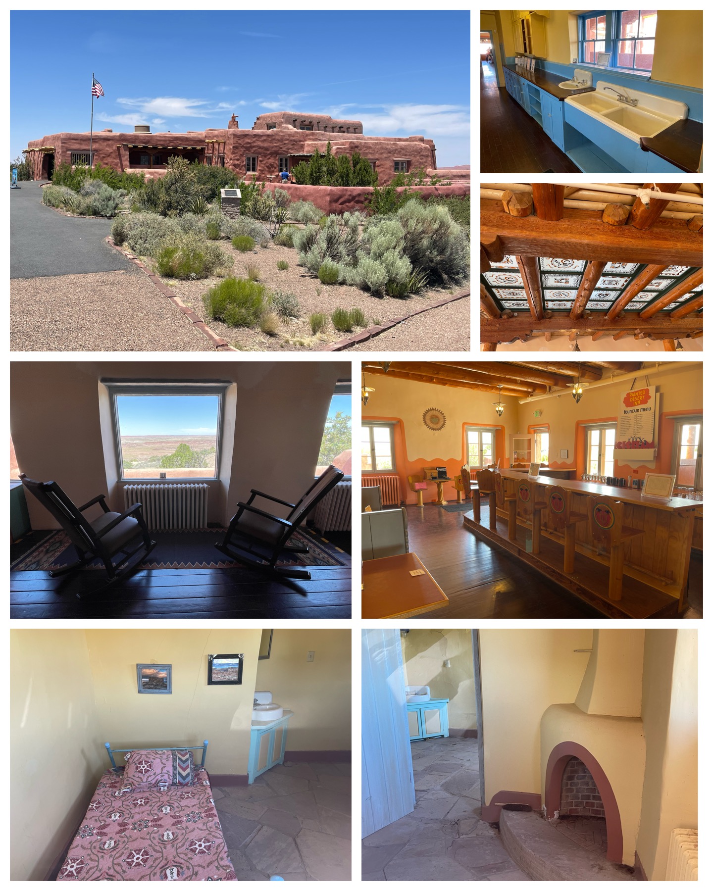 that took almost three hours to complete with all the stops and short hikes along the way. It really was breathtaking!
Among the first of the stops was a visit to the Painted Desert Inn. Designed in the Pueblo style, this inn was built by the Civilan Conservation Corp between 1937-1940, and was operated by the Fred Harvey Company, a hospitality industry business that owned chains of restaurants and hotels in the western US, from 1947 to 1963 when it was closed. It was slated for demolition in the mid 1970s, but public outcry resulted in its reopening, and subsequent designation as a Historic Place on the National Register in 1987. There was extensive rehab done to the building from 2004-2006, when it reopened as a museum, and how it exists to this day. It was a beautiful building, frozen in time from the early 20th century, with majestic views out along the Painted Desert. The bar/restaurant area and even the sparse, yet very nice rooms with a bed, bathroom,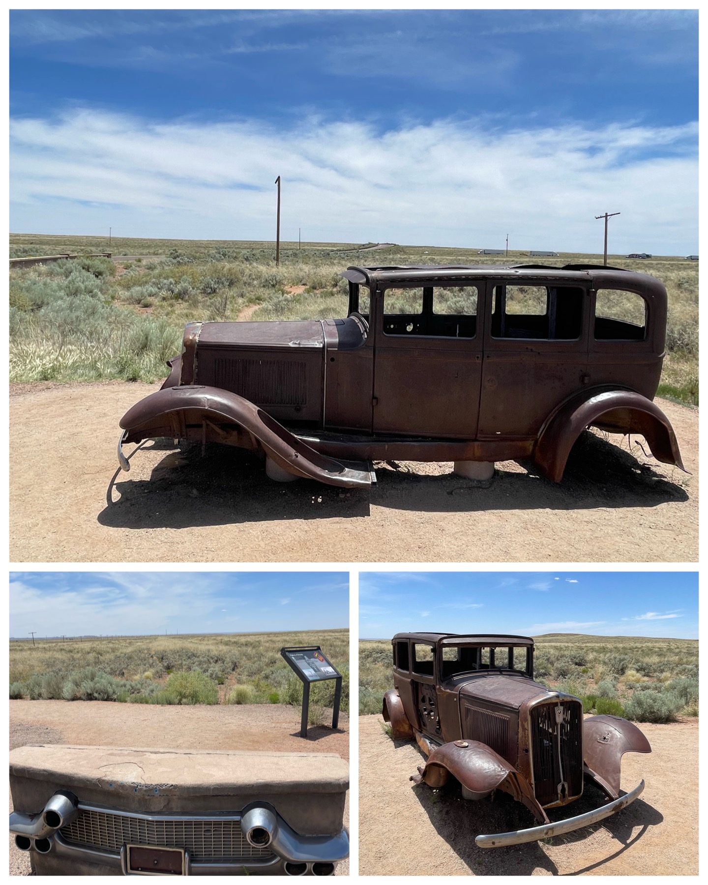 and fireplace, remain as they were back in the day. Even the painted panels used for the skylights remain in place. Really awesome!
A couple stops further down the road takes us to the Rt 66 dedication area known as the Highway of Dreams. Petrified Forest was the only Natonal Park that had a section of the old Rt 66 highway running through its boundaries. This section was closed down in 1958, and its now overgrown remnants can be visualized running down the length of the power poles in the distance (pictured at left, top). Several private businesses, including the Painted Desert Tower and the Painted Desert Park, were Rt 66 roadside attractions here within the National Park boundaries back in the day. All have long been shuttered and demolished. This legit shell of a 1932 Studebaker adorns this site and serves as a reminder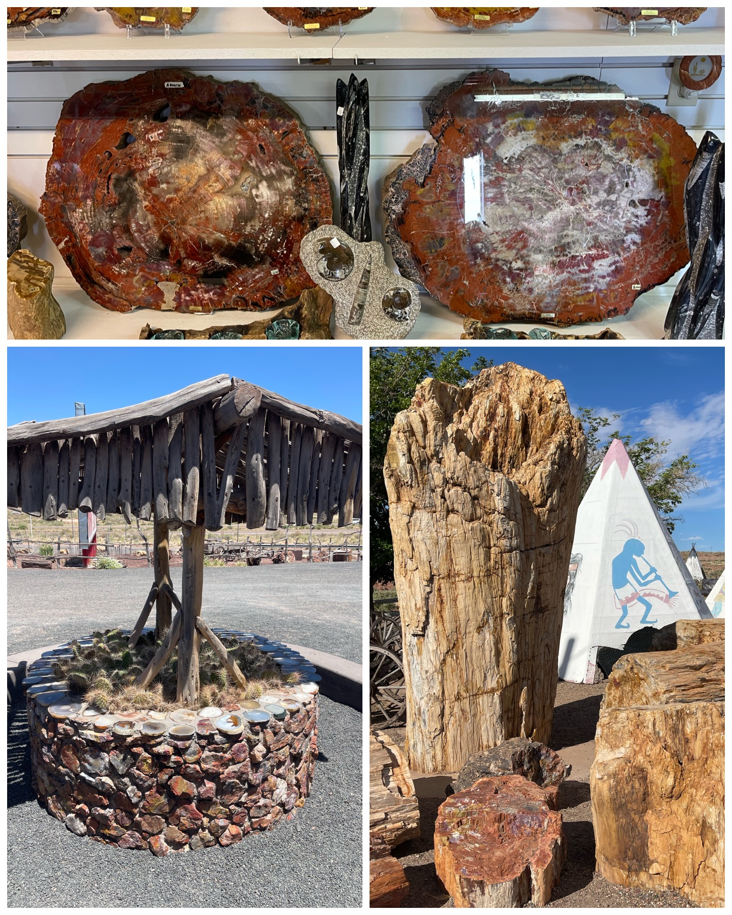 of what used to traverse this section of this highway. This was a fun and reflective stop!
As you would imagine, there are tons of shops in the area that use and/or sell petrified wood. One shop had a well made up of these colorful rocks. Another shop boasted having the worlds largest petrified tree – the largest piece standing 10 feet tall, and weighing in at over 80 tons (pictured at left, bottom right). And of course each shop had petrified wood for sale – ranging from a raw small fist size piece for around $5, to a 1-2 inch slice about 20 inches in diameter, and highly polished selling for around $7,000. So, clearly, there was something available for everyone and at every budget level. I’m thinking of getting a nice looking raw piece, maybe about no more than basketball size, that I can bring back to Florida and add to my landscape ornament collection. We will have to wait and see to a future blog edition if that ever pans out.
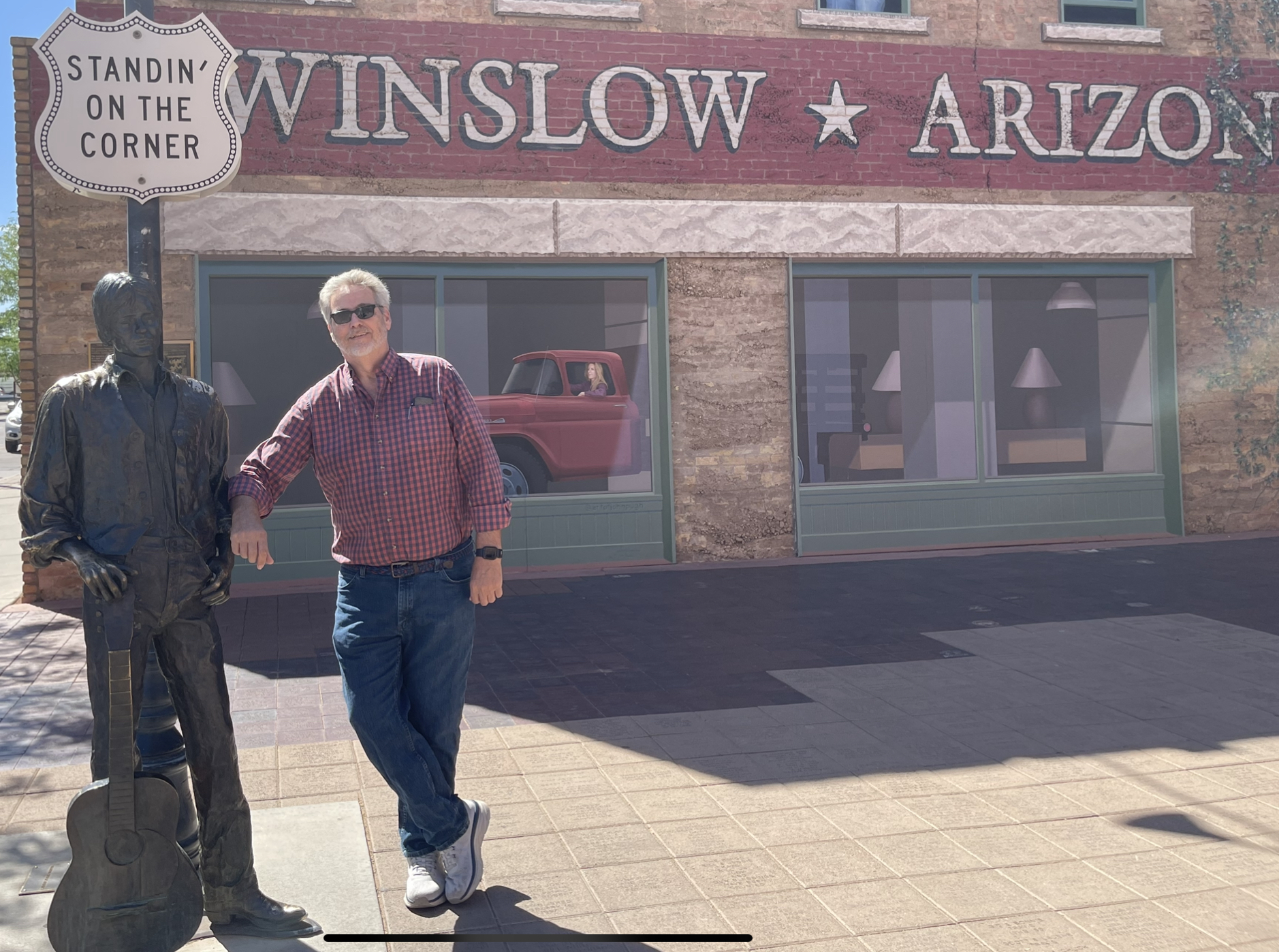
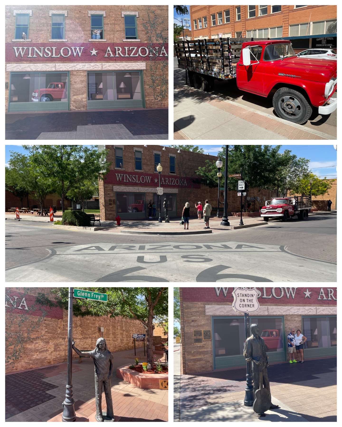 The next day, I made a day trip about 34 miles to the west to visit the town of Winslow. And yes, as the featured image at the top pointed out, I took the obligatory “standin’ on the corner” picture while I was there. As a refresher to you older folks, and by way of introduction to my younger readers who may have absolutely no clue what this is referring to, I’ll explain. Historic Rt 66 goes right down the middle of Winslow, and tourism from its travelers was how the town mostly thrived in the first half of the 20th century. In the late 70s, I-40 was built north of the town and served as a town bypass taking away all the downtown tourists. Consequently, tourism dropped significantly, and the town suffered badly economically. In the early 70s, musicians Jackson Browne and Eagles band member Glenn Frey wrote a song titled “Take It Easy”. The band Eagles, with Frey as lead singer, produced, recorded, and released the song in 1972 – being Eagle’s debut single. It was a huge hit reaching number 12 on Billboard Hot 100 later that year. If you are interested, you can listen to it HERE. Part of the lyrics written by Browne included the random verse “Well, I’m a standing on a corner in Winslow, Arizona – And such a fine sight to see – It’s a girl, my Lord, in a flatbed Ford – Slowin’ down to take a look at me”. Browne wrote that portion from his personal experience of actually having broken down in Winslow one time while traveling on his way to Sedona. Anyway, the song was a hit and sort of became a theme song while traveling down Route 66. Purists would stop in the town of Winslow and get a random picture at some random corner somewhere that had the towns name visible in the background – to sort of coincide with the song lyrics. So in the 1990s, in order to once again promote tourism to the town, they decided to avail themselves of the fame derived from the verse of that song, and built this plaza which would become the official “corner” on which to stand and get a picture (like I did). It has a statue of a random guy holding a guitar at the corner (pictured right, bottom right), a real red flatbed Ford along the road (pictured at left, top right), and murals on the back wall with the town name and of course a painted red Ford with a girl driver. Another statue was added in 2014 of Glenn Frey (at left, bottom left). The plaza was a huge success and reportedly, several hundred thousand people stop by every year for the photo op. So now I too am part of the club! And, I would not be at all surprised if my brother Dick is also a member of that club having done the complete Rt 66 road trip several years ago.
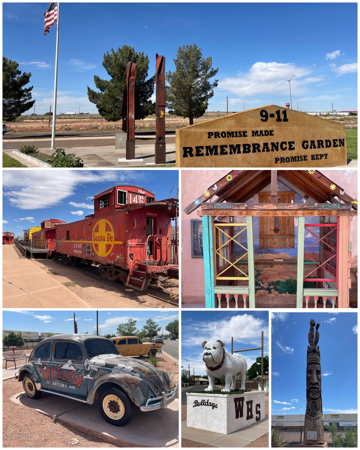 There were a few other notables in downtown Winslow besides the corner plaza. First up, they had a very nice 9-11 Memorial, complete with a pair of steel girders from the twin towers wreckage. Really nice! Also, the Santa Fe railroad traverses this area, so a small park with a few old rail cars from an earlier era are on display there. Next to the train were a couple of cool cars, painted very colorfully and on display. Winslow also claims to have this smallest church – officially the smallest on Rt 66 that is. This open air two-seater shack is a respite to weary and troubled travelers. Hardly a church though in my opinion. Then there’s this bulldog monument holding a fiberglass statue representing the local mascot to Winslow High School. Lastly, but certainly not leastly, I visited yet another one of the beautiful wood carvings of Peter Toth as part of his Trail of the Whispering Giants series. This is one of his earlier pieces from 1974, and has been well preserved here in Winslow due to its dry mostly warm climate. Funny thing that just the day before this visit, Peter Toth sent me a random text about some nonsense political stuff, to which I later replied “hey look – I’ve visited another one of your great works of art” complete with a selfie of me and his wood carving. I think he was pleased.
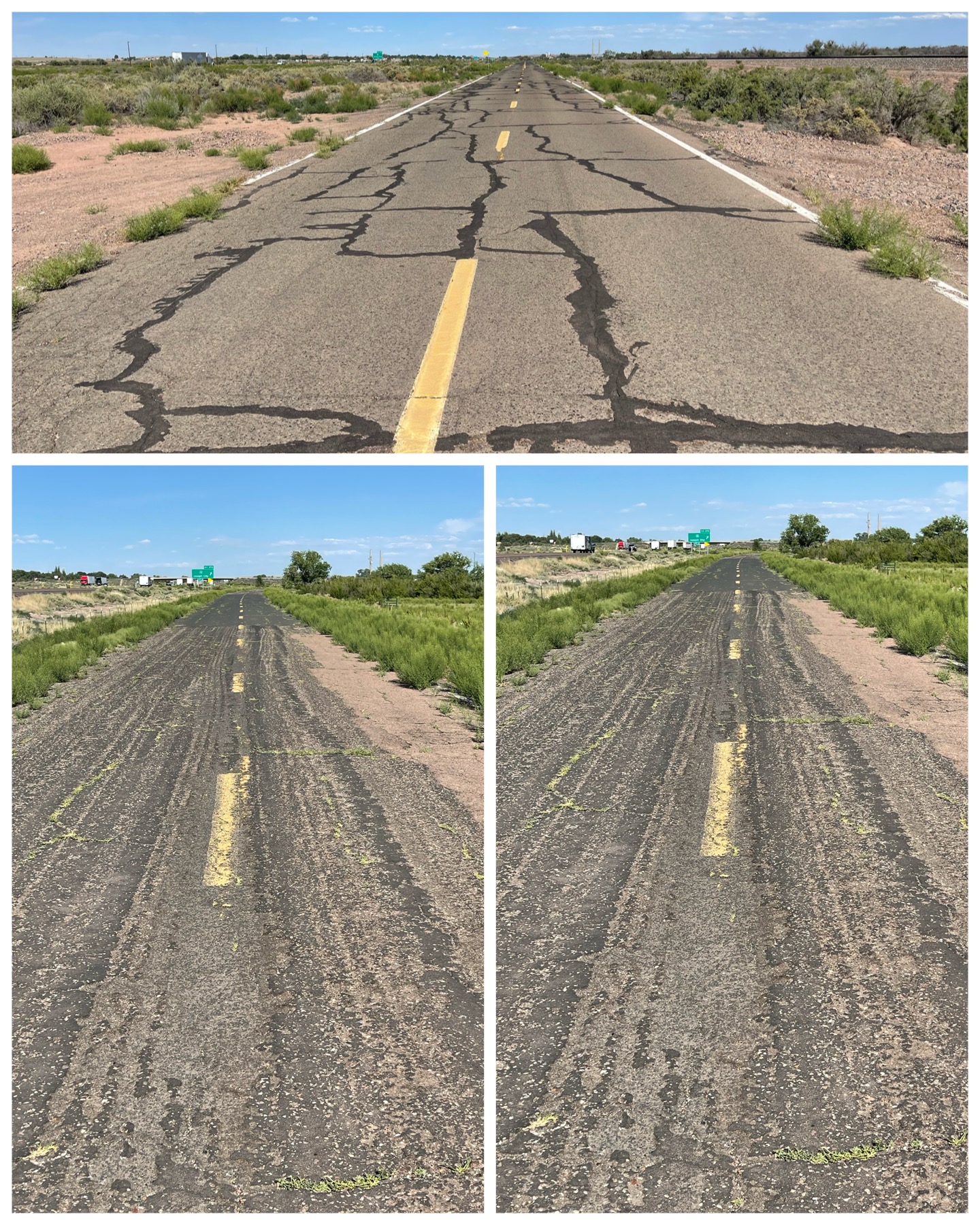 While on the subject of Rt 66, I’m troubled by the continued decline of legendary stops along the way, and the overall decay of the route itself. While visiting a few of the rock shops in the area along I-40, I found myself getting off the major highway and ending up on the original and historical Route 66. As you can see from a few pictures I snapped along the way, the road is in serious decline. I understand not every mile along the route will have some sort of shop or interesting stopover – I get that. But if you look closely at the pictures, you can see that the vegetation is creeping its way up along the sides of the road, and even starting to grow in some sections of the road itself. How long before this road also disappears? One of these days, I would love to take the complete trip of Rt 66 from its start in downtown Chicago, IL all the way to its end at the Santa Monica pier in California. And, I’d like my kids and grandkids to be able to make the same trip someday. But I fear that more and more of the road will vanish, as will the numerous stops and attractions that exist along the way. I frankly don’t have a clue how to preclude this from happening other than to take the journey myself and patronize as many of the businesses as I can along the way. I hope others will do the same!
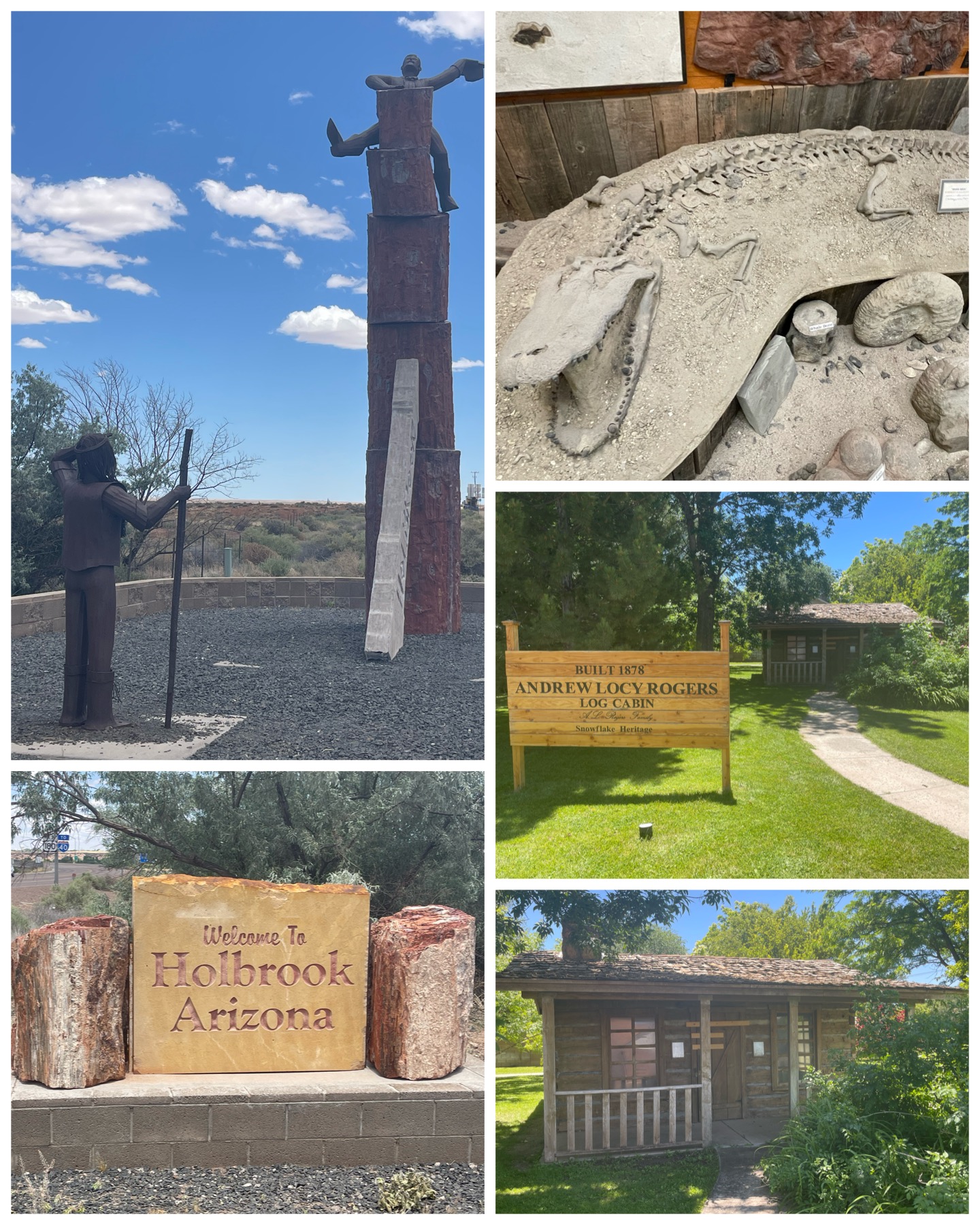 I spent the next couple of days exploring Roadside things to see in and around my host town of Holbrook. First up was a visit to the town welcoming sign along highway 77. There we find a stack of petrified wood sort of being ridden by a cowboy, with an Indian looking on. I’m not exactly sure what the significance of this is, but it certainly was interesting. Just down the road from there was Jim Gray’s Petrified Wood Company. Besides there being tons of petrified wood in various shapes, sizes, levels of finishes, and pricing, there was also Wild Bill – an estimated 3 billion year old fossilized alligator. And of course, he’s not a native of AZ, but rather was acquired from Florida by the shop owners to serve as an added attraction to the store. He sure looks like the alligator we all know and love today. Not much has changed over the subsequent several billion years. Last up I took a drive south to the quaint little town of Snowflake to see this seemingly normal looking log cabin. What makes it unique however, is the story that goes with it. The cabin was built in the mid 1870s by Andrew Locy Rogers. As his family grew, so did his needs for living space. He ended up covering the walls, floor and ceiling of the cabin in drywall, and over time ended up building a complete two-story house around the cabin. Fast forward several generations when Andrew’s great grand children occupied the house, where the existence of the cabin had totally been forgotten. That is until a fire in 1989 burned the house down. As the remnants from the fire were about to be bulldozed, the workers notice some logs, pulled back the drywall, and found the log cabin fully intact and unharmed by the fire. And this is that cabin. Wow – what a cool story!
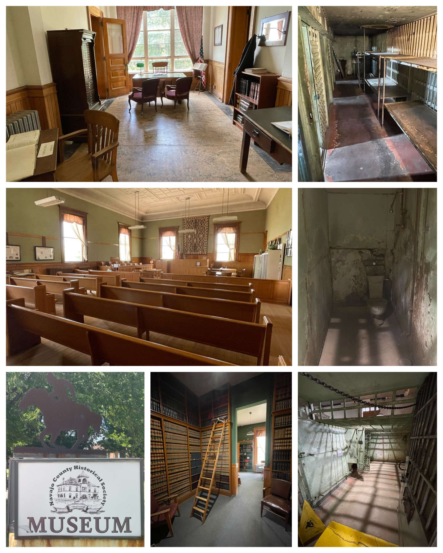 Next, I payed a visit to the Navajo County Museum in downtown Holbrook. The museum resides in what was the County Courthouse from the late 1890s thru 1976. What I found most interesting were the jail cells that were built and used there. They came from the Pauly Jail Company out of St. Louis, MO, and were shipped here to Holbrook via a railroad flatcar. The door mechanisms seemed really advanced for something built in the 1890s, and the cells themselves certainly had a creepy vibe about them. Certainly not luxury accommodations. It was reported that from 75 years of usage, no one had ever escaped from these cells. The rest of the courthouse museum included the original courtroom, judges chambers, and extensive law library, and other sections depicting other areas of history – including a post office, pharmacy, barber shop, bank, school house, and even the pony express. They also had a pretty nice collection of old typewriters, adding machines, and various recording equipment. Overall, a really nice and impressive local/regional museum.
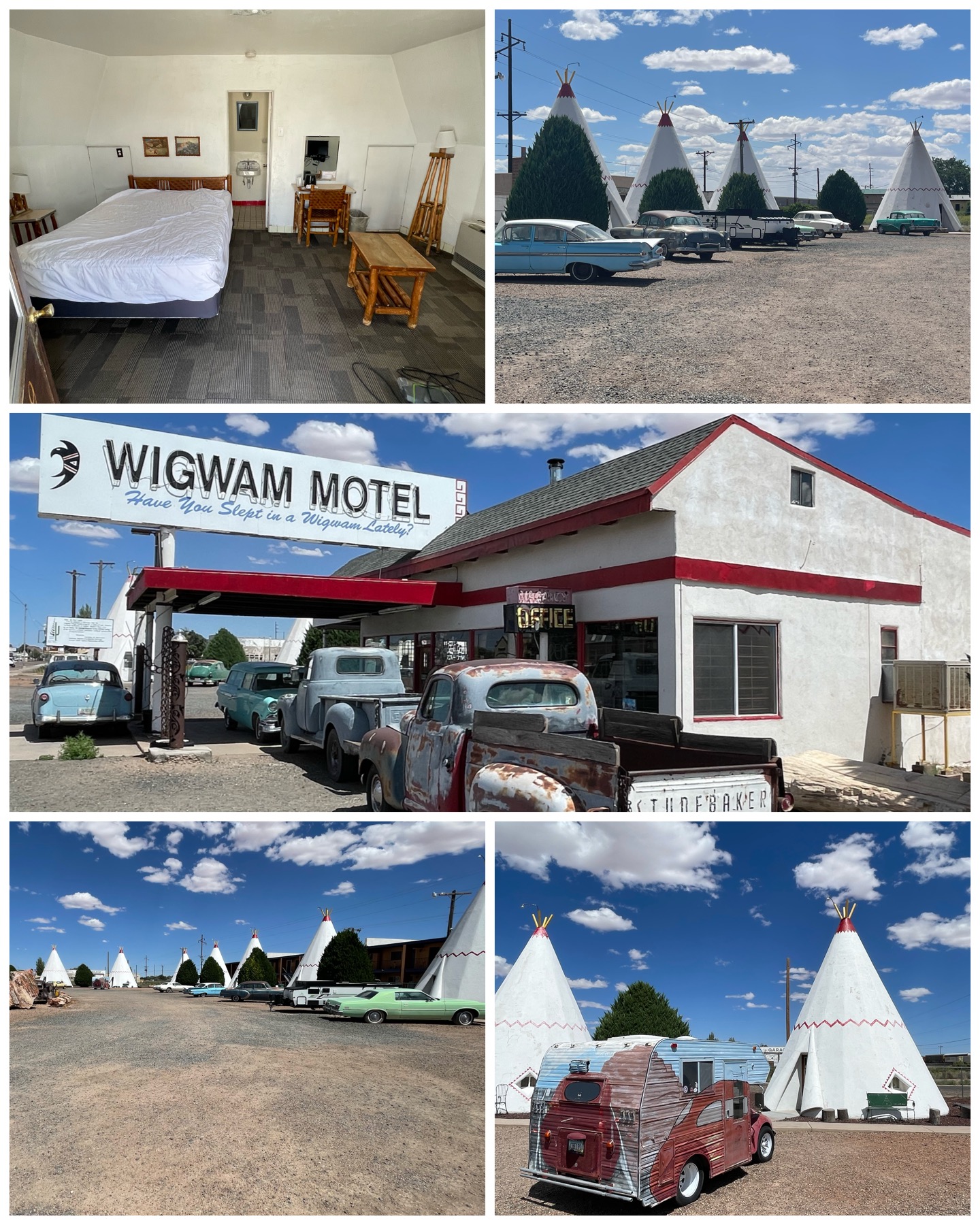 My last visit in the area was to the Wigwam Motel. This place was really interesting! It was added to the National Register of Historic Places in May 2002. This Rt 66 landmark was built in the late 1940s, and was #6 of a total of 7 Wigwam Villages built around the country. It started with Village #1 built in Cave City, KY in 1937, which added these concrete tipi-like structures known as wigwams that contained simple sleeping accommodations. They were created on the thought that they would be of interest to travelers. The idea took off, and six others villages were built – bringing two in KY, and one each in AL, FL, AZ, LA, and CA. Sadly, only three remain in existence today – the one here in Holbrook, the original one in Cave City, KY, and one near San Bernardino, CA. Interestingly, the one in FL (#4) was actually in Orlando at 700 S. Orange Blossom Trail . It was the largest of the 7 villages with 27 guest wigwam rooms. It was leveled in 1973/74 to become a Days Inn, which later became home to the 330-room Vacation Lodge that remains today. I suppose that’s progress (he says sarcastically). The Holbrook village still operates today, and as luck would have it, the rooms were being serviced while I happened to be there, and one of the doors was open that allowed me to peek in to get a few shots of the inside. Nothing real fancy, but hey, your sleeping in a wigwam! What is also especially cool is each of the 15
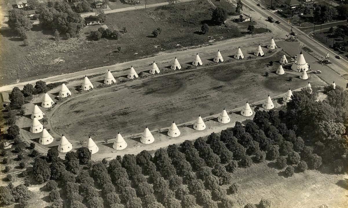 wigwam units has an old historic (likely not running) classic car parked out in front of it – making the entire experience feel like your back in the 50s or 60s. For about $100 bucks a night, you too can try your hand at sleeping in one of these iconic overnight accommodations.
Nov 2023 Update: My sister-in-law Deb spotted this awesome picture on FB of the Orlando Wigwam Motel Village from 1949. As noted above, it had been demolished in 1973/74, so this historic picture showing what it looked like soon after being built is priceless. Deb tagged and shared the picture with me, so I figured I’d pay it forward and share it here as well. Thanks Deb for sharing this awesome photo with me. It really fills in the Wigwam experience – at least from an Orlando perspective.
Flagstaff, AZ
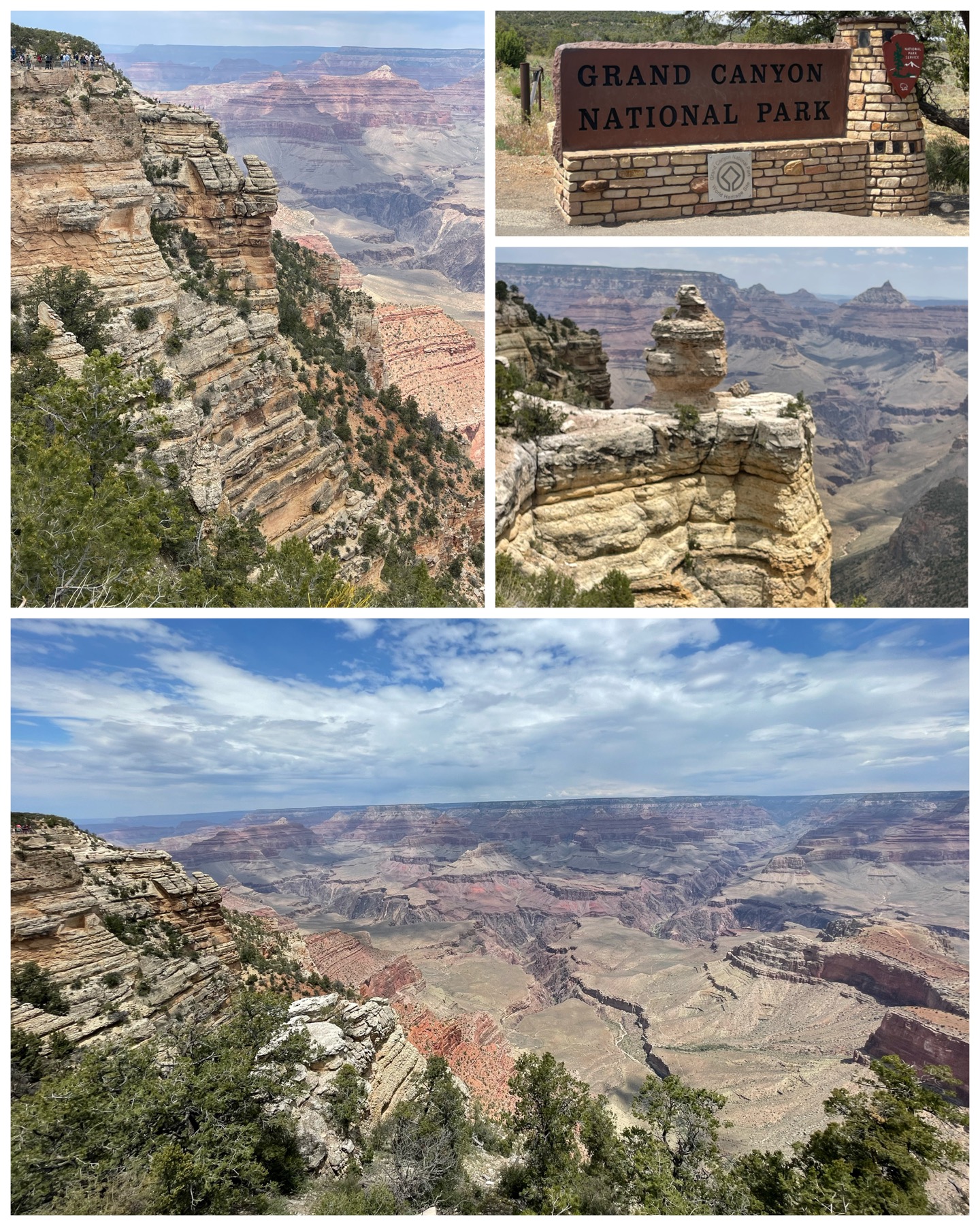 Wow – just wow! I’ve often heard that pictures of the Grand Canyon never do justice to the magnificent views you see when you are there in person. Boy, do I believe that now more than ever! I had never been to the Grand Canyon National Park, and was extremely anxious to see it. So much so that I made it my absolute first destination upon my arrival here in Flagstaff. It would be the South Rim that I would get to see from this vantage point, getting to the visitor center in about 1 hr and 20 min. It was packed! After finally finding a parking spot that would accommodate my monster truck, I spent about an hour there taking in all these stunning views that were there. Then, I travelled the 20 or so miles east on Rt 64, Desert Drive, stopping at all the scenic overlooks along the way – of which there were many. It was just one incredible scenic view after another. Even though you are looking into the same canyon, each viewpoint had its own unique geography and special colors. It was nothing short of spectacular! I took many pictures at each stop – too many to share here. So be sure to check out the photo album link down at the bottom to see all the pictures in all their glory.
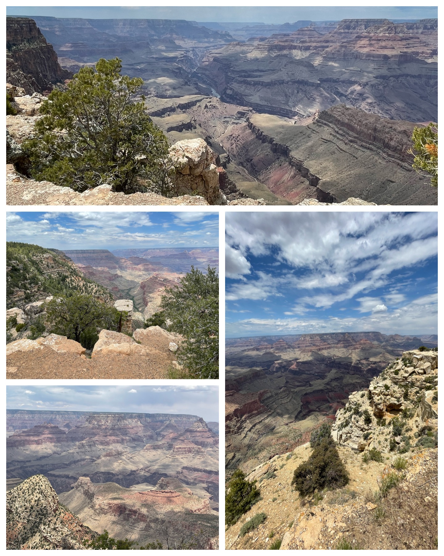 So now, a bit of history so that this write up will have its necessary educational component. The canyon is 277 miles long, and up to 18 miles wide in places, and at 6,000 feet deep is over a mile down. It was carved into the landscape by the Colorado River over the course of many millions of years – anywhere between 5 million and 150 million years depending on which study you care to subscribe to. But in any case, it took a minute. President Theodore Roosevelt, a frequent visitor to the canyon, established the Grand Canyon Game Preserve in 1906. That later became a National Monument in 1908 after the passing of the Antiquities Act of 1906. Congress then established it as the 17th National Park, then signed into law by President Woodrow Wilson in 1919. Today, Grand Canyon National Park is one of the world’s premier natural attractions, bringing in about five million visitors per year. There are two primary viewing locations – the North Rim and the South Rim. Fun fact that helps visualize the sheer magnitude of the canyon – if you wanted to drive from the South Rim to the North Rim, it’s 220 miles and would take you about 5 hours. Now that’s big! Also of interest, of those 5 million annual visitors, 90% visit the South Rim, while only 10% visit the North Rim. This visit and these pictures were from the South Rim (I hope to be doing the North Rim in a couple weeks). Think of the South Rim like Disney – extremely busy and crowded, while the North Rim is more laid back, remote, and not near as busy. The South Rim has dozens of viewing points, while the north only has three. The south is more canyon-like with lots of rock surfaces, while the north is greener and more forest like. Anyway, the debate goes on as to which is better, and I’ll have to wager in my $.02 worth after I’ve completed my visit to the north. But I would make this one comment – everyone MUST put this place on their bucket list! The views are just so incredible and have to be seen and experienced in person.
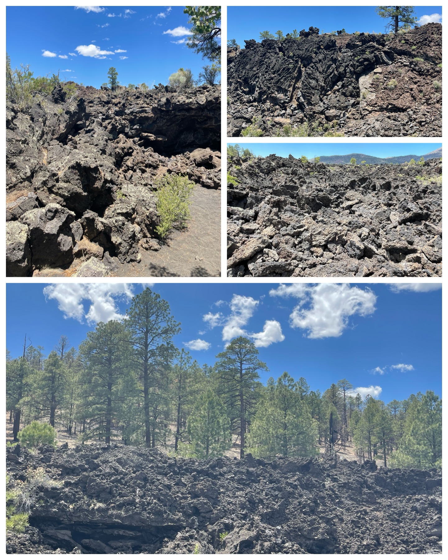 My next day of adventure would take me to two additional NPS sites – two National Monuments. Just north east of Flagstaff from Rt 89 I picked up Fire Road 545 – which is a 35 mile loop road that takes you past two National Monuments, then dumps you back onto Rt 89 further to the north. The first park I visited was Sunset Crater Volcano National Monument. From geological studies, it is estimated that this volcano erupted approximately 1,000 years ago, producing a blanket of ash that extended over 800 square miles. Trails throughout the park take you along hillsides covered in black ash and lava rocks, though sadly the trail leading to the rim was closed in 1973 due to erosion caused by hikers. But even from the base, it was really cool looking! It was President Herbert Hoover that gave the National Monument designation in 1930. Most recently, in 2022, the Tunnel Fire burned throughout the monument, but sparing the visitor center. While I did observe lots of burned trees, I also saw lots of greenery suggesting a nice comeback from the fire. This was definitely a worthy stop in the area.
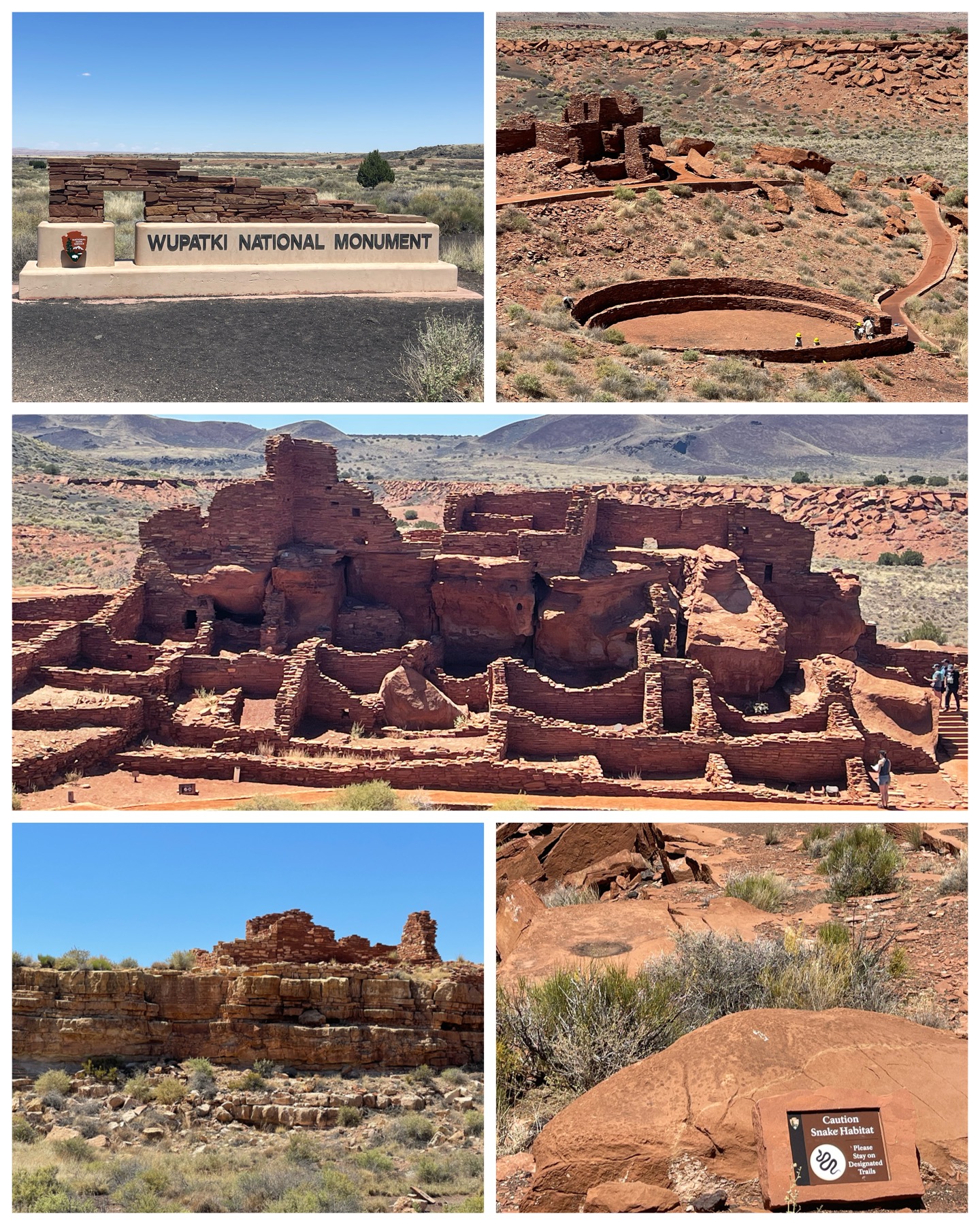 Further along the loop road brought me to the Wupatki National Monument visitor center. This National Park Service managed monument is host to an extensive collection of Native American archaeological settlement sites. It is made up of three building and 29 structures contained within 35,400 acres of land. These settlements were built by the Ancient Pueblo People, where hundreds once lived and farmed. The largest structure is the Wupatki Pueblo (pictured at right, center). It had more than 100 rooms and is believed to be the region’s tallest and largest structure. Other smaller villages were located for miles throughout the area, but this Pueblo was the centerpiece – believed to be occupied by those who held ritual or leadership roles. The circular gathering and ceremonial place (pictured at right, top right) would have been used, for example, to celebrate the harvest or to conduct ceremonial rituals. It is believed these villages were occupied until about 1225 when the sites were permanently abandoned. This area was designated as a National Monument in 1924, and placed on the National Register of Historic Places in 1966. Also present throughout the area were these warning signs (pictured at right, bottom right) warning of the presence of snakes. Didn’t need to tell me twice – I stayed clear of everything that wasn’t a concrete trail.
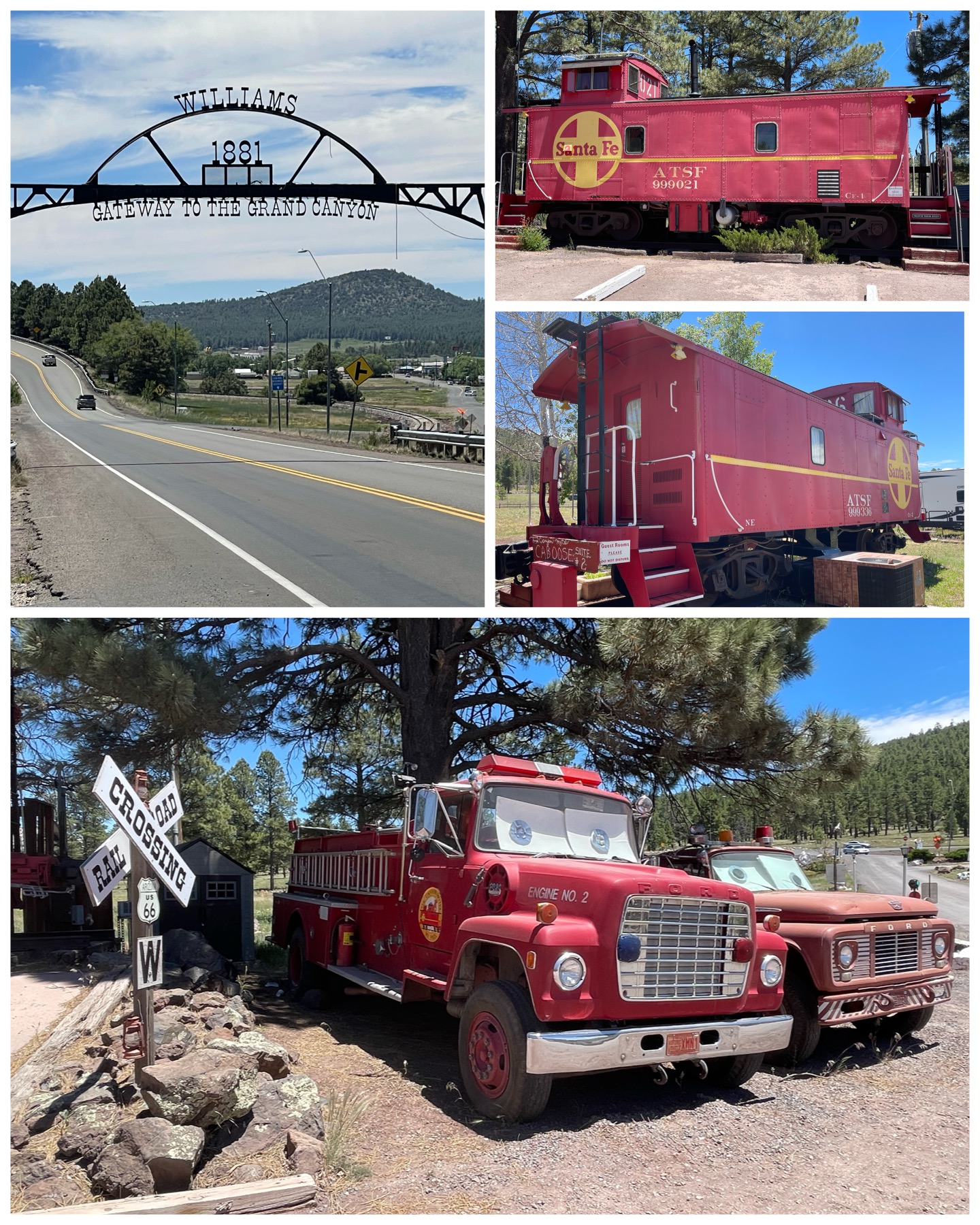 My last ventures in and around Flagstaff had me chasing several Roadside America sites. First up, I took a drive west to the town of Williams, AZ. A really cool Rt 66 touristy area, but keeping much of its legacy charm. First up was a visit to the Canyon Motel and RV Park which, among its many amenities, has a pair of 1920s era cabooses converted to guest suites. Reportedly, one of them has been officially certified as haunted by a team of ghost hunters who happened to be passing through. So, if you’ve ever wanted to spend the night in a haunted caboose, this would be your ticket! They also had a collection of old antique fire trucks. I’m not sure if they are running and/or what they do with them. Maybe just something interesting to look at while your staying at their place. They were kinda cool. The main road leading into town (Rt 66) had a nice iron piece hanging across the road welcoming you into Williams – apparently known as the “Gateway to the Grand Canyon”. Rt 64 heading out of Williams takes you dead north for approximately 60 miles leading directly into the Grand Canyon Village and the south rim – so yea, I guess you could call the town a gateway.
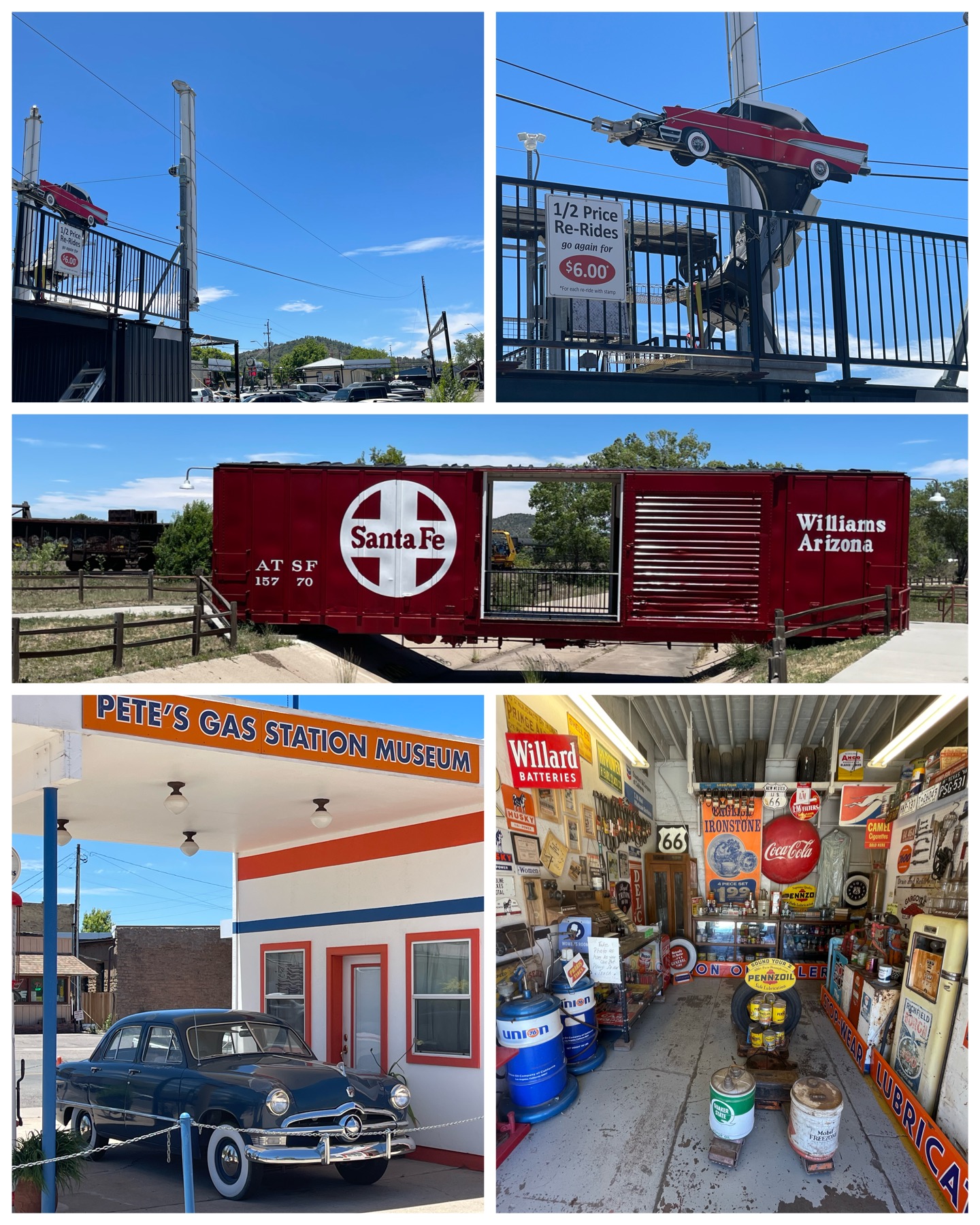 The Williams downtown was actually quite nice. Rt 66 is split east and west and runs directly through town, with ample historical places to visit on either side. One such place was Pete’s Route 66 Gas Station Museum (at right, bottom). This restored gas station turned museum sports a 1950s Ford sedan parked in front, and a nice collection of historic gas station and Rt 66 memorabilia inside. The museum is free, but donations and/or patronage with the attached small gift shop are welcome. I bought myself another Rt 66 hat to enjoy. Also in town is the Rt 66 Zip Line – a pure tourist item that was fortunately closed while I was there (not something I’d get on for sure). There was also an old rail car that was turned into a bridge. Now that was definitely cool!
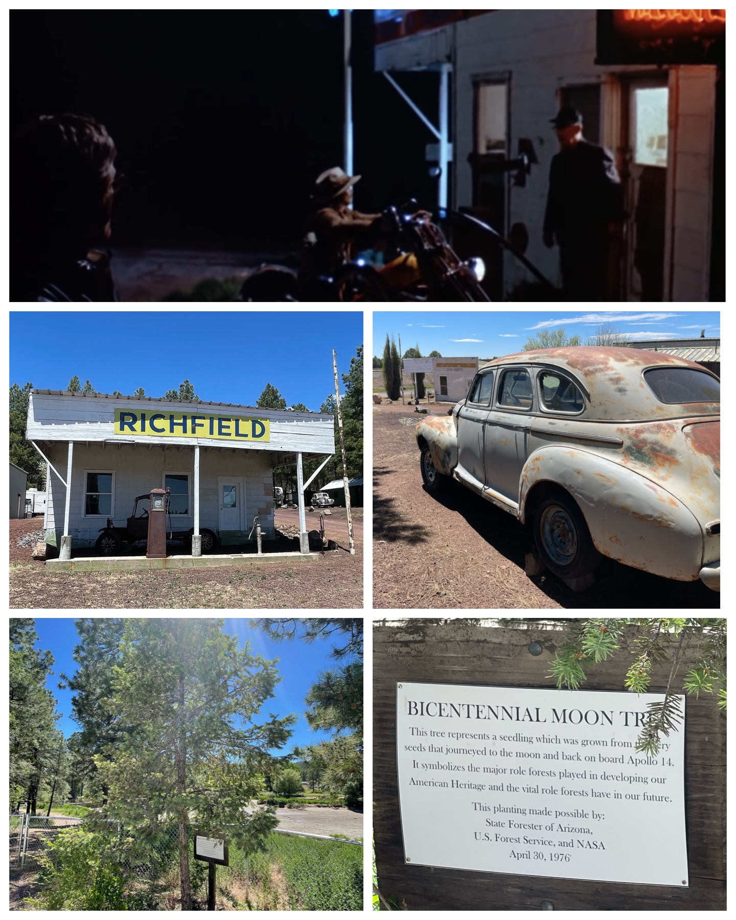 My last couple of tourist stops would take me back to the area in and around Flagstaff. First up was a trip to visit the Pine Breeze Inn and RV Park. There was nothing special about the RV park which was heavily tree lined and only had spots for about 25 RVs, and the buildings that once were cabins and part of the Inn have long since been closed. What made this stop interesting was the old Rt 66 gas station out front (pictured at left, center). Not just your average Rt 66 gas station, but the one featured in the movie Easy Rider (at left, top). This is where Wyatt ad Billy attempted to stop for the night, only to be denied by way of the No Vacancy sign. Though the scene from the movie was shot at night and is dark, you can clearly see this building in the background. The actual No Vacancy sign is supposed to be somewhere in some building in the campground, but alas I was not able to find anybody who could show it to me. Oh well! Last up on this trip was a visit to a tree – notably the Bicentennial Moon Tree. This tree was reported to have its origins from the seeds that were carried into space aboard the Apollo 14 mission – making this what is called a moon tree. It was planted on Apr 30, 1976, the year the Bicentennial was celebrated. The seed was germinated at some unknown location in Flagstaff, then the seedling planted here. However, according to a story in the Arizona Daily Star, that seedling was pulled out of the ground and killed just a few days later by some local thugs. So, a replacement seedling, not from the seeds of the Apollo, was planted in its place. Legend has it that the soil which once contained the moon tree has some how enriched this replacement, sort of making it a moon tree. Hmmm – that sound like a stretch to me. But certainly a sad ending to what would have otherwise been a pretty cool tree.
Final Thoughts
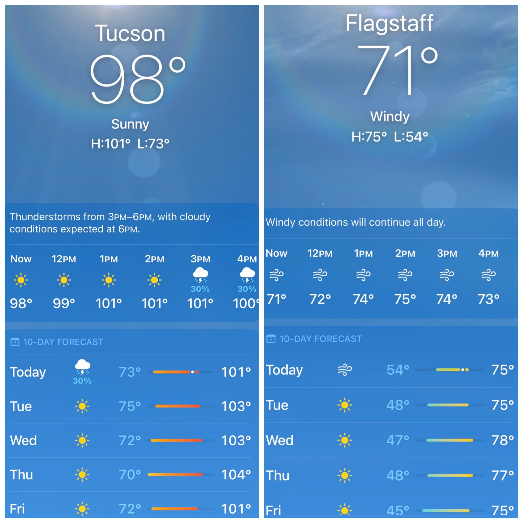 One of the first things I noticed when I landed in northern AZ from Tucson and Phoenix was the much more pleasant and cooler temperatures. Phoenix at 1,100 ft and Tucson, at 2,400 ft elevations and both in the Sonoran Desert were significantly hotter than both Holbrook and Flagstaff at 5,000 ft and 7,000 ft elevation respectively. As you can see from the weather app screenshots at right from the same exact time period, the weather up here in northern AZ has been spectacular! Certainly much nicer than those desert towns. However, I fear as I travel to my next destination of Page, AZ at 4,000 ft, I’ll be back to the hot, but not humid, temperatures. But that’s ok – I certainly had a really nice past couple of weeks. So one more week in AZ at Page, then I’m off to the great state of Utah where I’ll spend a month and a half touring around and seeing many of the wonderful sights there. I’ll also reconnect with a couple former coworkers, and once again enjoy a slice or two of pizza from my all time favorite pizza joint – The Pie. Definitely looking forward to all of that. Till next time, be well and safe travels.
I only show a sampling of my adventure pictures here in the blog, and do so mostly in collage format for brevity and ease of reading. If you want to view an album containing individual full fidelity and hi-res images of all my travel pictures related to this specific blog, click the image below. Enjoy!

Really enjoyed this blog! When I was a kid, we embarked on a road trip to accompany my Dad’s sister from New England to California. She was a nurse and had accepted a job at City of Hope in Duarte, CA. We drove her car and then flew back. Quite the adventure for a 9 year old! I don’t remember all of it (was way back in 1964) but definitely remember stopping at the painted desert and petrified Forrest and most especially the Grand Canyon. Simply spectacular. And I can’t swear to it, but I have a vague remembrance of sleeping in a teepee. Maybe we stayed at the Wigwam Motel.?? Unfortunately the adults who accompanied me on the trip have since passed so I have no way to verify. 🙁
Loved the picture ” standing on the corner in Winslow Arizona….” Awesome!!
Looking forward to the next blog from Utah!! Safe travels.
Nice that you have a recollection of those trips from your youth. My daughters often reminisce about the many camping trips we took when they were young. There is nothing better than building lasting memories.
This edition brought a lot of memories for me as I have been to practically all the spots you visited. And yes I do have the obligatory photo of me standing on the corner. Despite the fact I had my trailer with me, I had it in a campground down the road and went back to Winslow where I stayed the night at the La Posada Hotel, Fred Harvey’s last great railroad hotel. It was a great stop and the restaurant was quite good. There is a book abut the “Harvey Girls” as It was quite an interesting job opportunity back in the day.
I also agree with you that rt 66 should be saved. When I did it I did stop at EVERY attraction and supported all the businesses and museums along the way. I did it over 5 weeks which allowed the time to see everything. I met other tourists, many from Europe, who only had two weeks which is way too quick. I did think about staying in the wigwam, but opted for my trailer instead. Now I wish I had tried the wigwam.
Keep enjoying your travels.
I figured this blog would bring back some of your memories. Lots of great Route 66 areas of interest here in northern AZ. I did see La Posada – quite the place. After spending time around here, I’m even more excited to take the Route 66 ride. In fact, I think I’ll start planning now to do it in 2026 for the route’s 100th anniversary and Centennial. That sure would be a blast.
Bruce, A very enjoyable blog. I think I will share it with my children. Our son Phil is driving across the country and perhaps he can be encouraged to get off the highway and see some of the sights via Route 66. Plus, the history of the song could be of interest to our children who are in their late 30’s and early 40’s. I’ll have to look for Roadside Attractions in Livermore, CA the next few weeks. Talk to you later. Continued safe travels. Paula
Hi Paula. Indeed, there are 29 Roadside America attractions within 20 miles of Livermore, CA. There are 5 actually in Livermore – the most interesting of which are the longest continuously burning lightbulb – located at the Livermore-Pleasanton Fire Dept Station 6, the 6,000 beer can display (noted to be the country’s largest collection on public display) – located at the First Street Alehouse, downtown, and the Nuclear Laboratory Discovery Center – located at the Lawrence Livermore National Laboratory. You can get all the details at RoadsideAmerica.com. I hope you get a chance to check out some of these gems! Enjoy your travels.
Wow love Grand Canyon pictures. Love reading your blogs so informative and interesting.