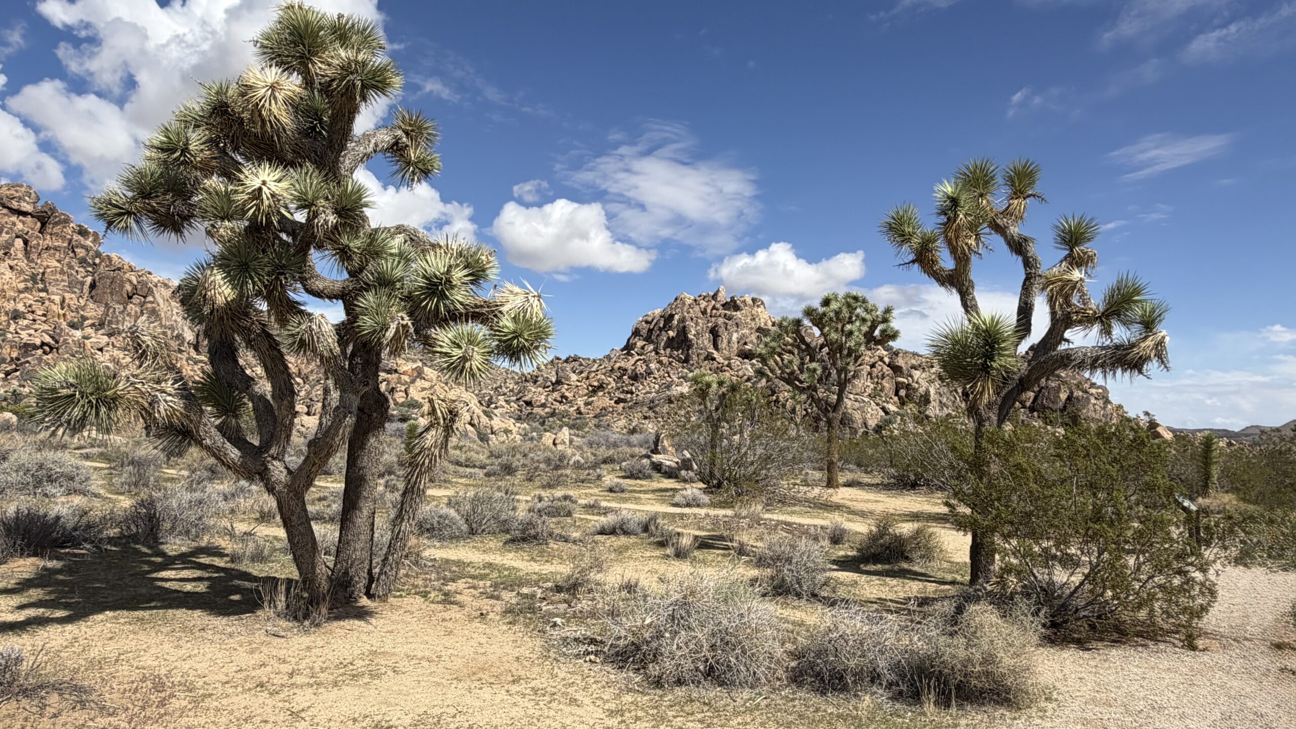
Nothing compares with the desert south west for its natural earthy beauty. Joshua Trees, native only to this area of the world, are ever present along the desert landscape – especially here in their namesake national park. This leg of the journey concludes my pacific coast adventure, as I begin my trek to the east back to the Florida home base. Still lots to see and explore in these final weeks – all of which will be shared and detailed here in the blog. So, let’s get to it!
Greenfield, CA
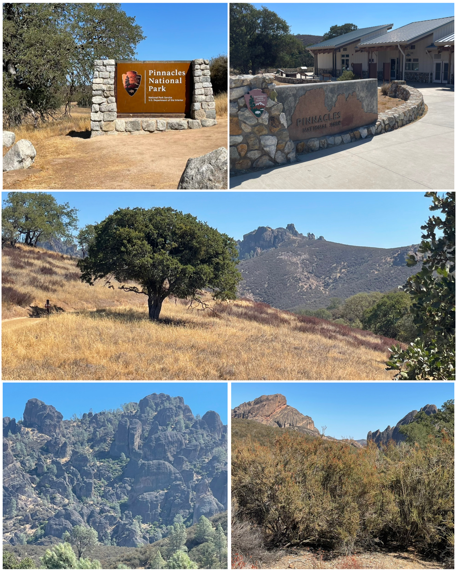 As I continue my trek south through California, my next stop is Greenfield which was the launching point to visit Pinnacles National Park. The park’s namesake pinnacles or spires are remnants of eroded ancient volcanos. It is estimated that the volcano had moved here to the California Pacific Coast some 200 miles from its original location on the San Andreas Fault. That’s quite the migration! President Theodore Roosevelt established this area as a National Monument in 1908 when he set aside 2,080 acres. The protected area has grown to the present 26,606 acres, and in 2013 was redesignated as a National Park. A beautiful scenic drive, albeit of a very narrow single car wide variety, takes you through the park offering stunning views. In fact, the deeper I got into the park along this road, the more nervous I got that I might run into another car, or worse a big truck, coming the other direction. The road was very winding with sharp switchbacks that would have made passing another car extremely sketchy. As a result, I decided to cut my drive a bit short of the entire run and took the opportunity to turn around in one of the pull-off view points. Fortunately, it was either a slow day or this park doesn’t get too many visitors, as I only had to navigate passing a few cars along the route and did so in areas that had enough room to pull aside. Still, not a great road for a big boy truck. Also, when I was at the visitor center, it was void of any park ranger or otherwise any volunteer working there. There were several other visitors with me in the center, some of whom wanted to purchase items from the gift shop. I wanted someone to start the informational video about the park. As it turned out, we were all disappointed as no worker ever showed up. We could have robbed the place blind if we wanted. As it turned out, some of the other visitors simply left some cash on the counter to pay for their souvenirs. Not sure what was going on at the time, but it must have been something urgent to have left the place wide open.
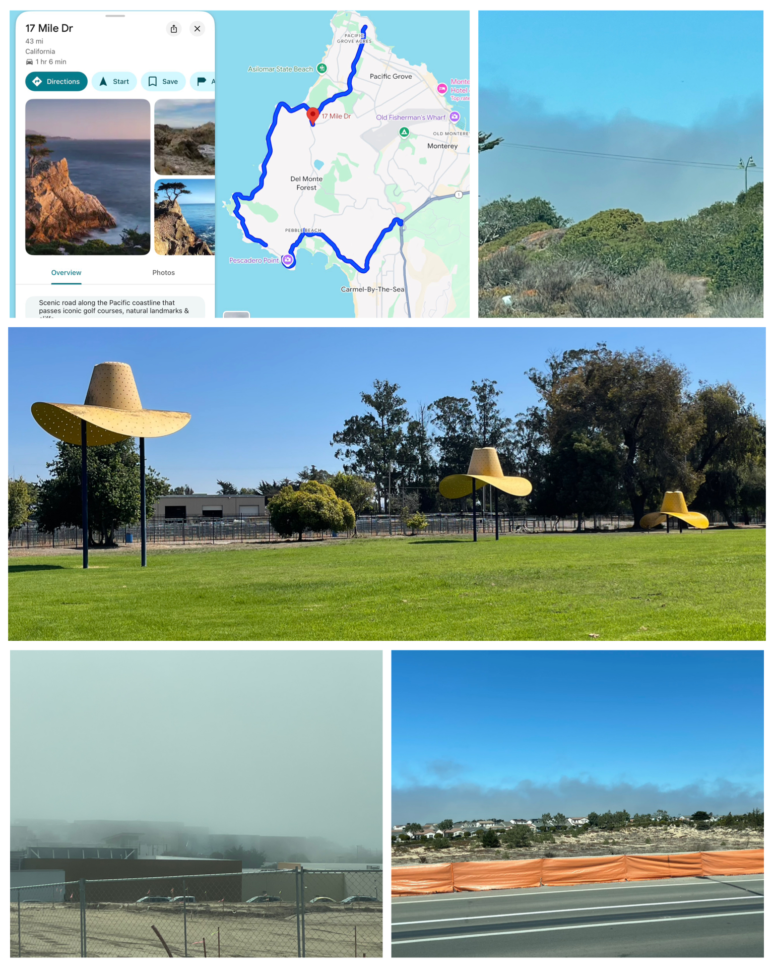 The next day I had intended to hit some Roadside items towards the north east of me, and also take a tour of Monterey peninsula – specifically Pebble Beach along the famous road known as the 17 Mile Drive. As you can see from the map (at right, top left) this route hugs the Pacific coastline as it passes famous golf courses, residential mega-mansions, and scenic attractions including some Roadside treasures. Though the road is technically a public roadway, if you are not a resident there, they charge you an entrance fee (I think $12) to access the road. But, there was plenty to see and explore so the fee was negligible and worth it. As I was approaching the area, I could see what I originally thought might have been a fire or perhaps some dense clouds up ahead (at right, top and bottom right). As I got closer to jumping on the 17 Mile trail, I then recognized that this was not clouds or a fire, but rather a hugely dense fog that pretty much filled the area making for some really bad visibility (at right, bottom left). Well, I decided it wasn’t going to be worth my entrance fee to drive through dense fog, and not see a thing along the way. So, I turned back and called that trip a bust. On the way back to the campground I stopped in Salinas to at least see this one Roadside item. Known as the Hat in Three States of Landing, it is the work of Claes Oldenburg in 1982. Located near Sherwood Park and the Silinas Sports Complex that features the California Rodeo, this art piece is meant to depict a hat thrown from a rodeo cowboy as it floats to the ground. Pretty cool!
Reedley, CA
My next stop takes me 100 miles towards the east to the San Joaquin Valley and the town of Reedley where I would spend the next five nights. A good sized town with a population exceeding 25,000, and having its primary economy being agriculture – notably fruit and vegetable production. So much so that it has dubbed itself “The World’s Fruit Basket”. It is also located just 20 miles or so from Fresno – a target town of mine to be explored.
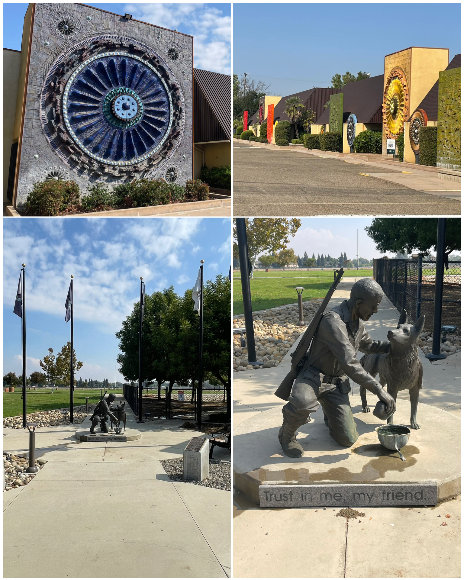 My first tourist day would take me to the northwest to the Fresno area – first to the town of Clovis where I would find these Roadside gems. First up this ceramics products facility located in an industrial park, that has over a dozen huge, colorful, 3D ceramic sculptures. Artist Stan Bitters used thousands of glazed ceramic pieces to create these beautiful abstract art pieces to adorn the outside walls of this facility in 1969. Really nice! Next I visited a monument that my sister-in-law Debbie will most likely enjoy. Titled “Trust in Me My friend”, this is a life-size bronze sculpture of a GI pooring water from his canteen into his helmet for his trusty canine companion. This one, unveiled in Nov 2014, is one of many monuments located in Clovis that honors military veterans and police K-9s. What makes this even more special is that water is actually being pored into the helmet, offering a never ending quick drink for any thirsty passing by animals. Even more so, this particular monument sits just outside of the parking area to the towns animal rescue and adoption center. What a perfect tribute located in the perfect location to honor and serve. Truly amazing!
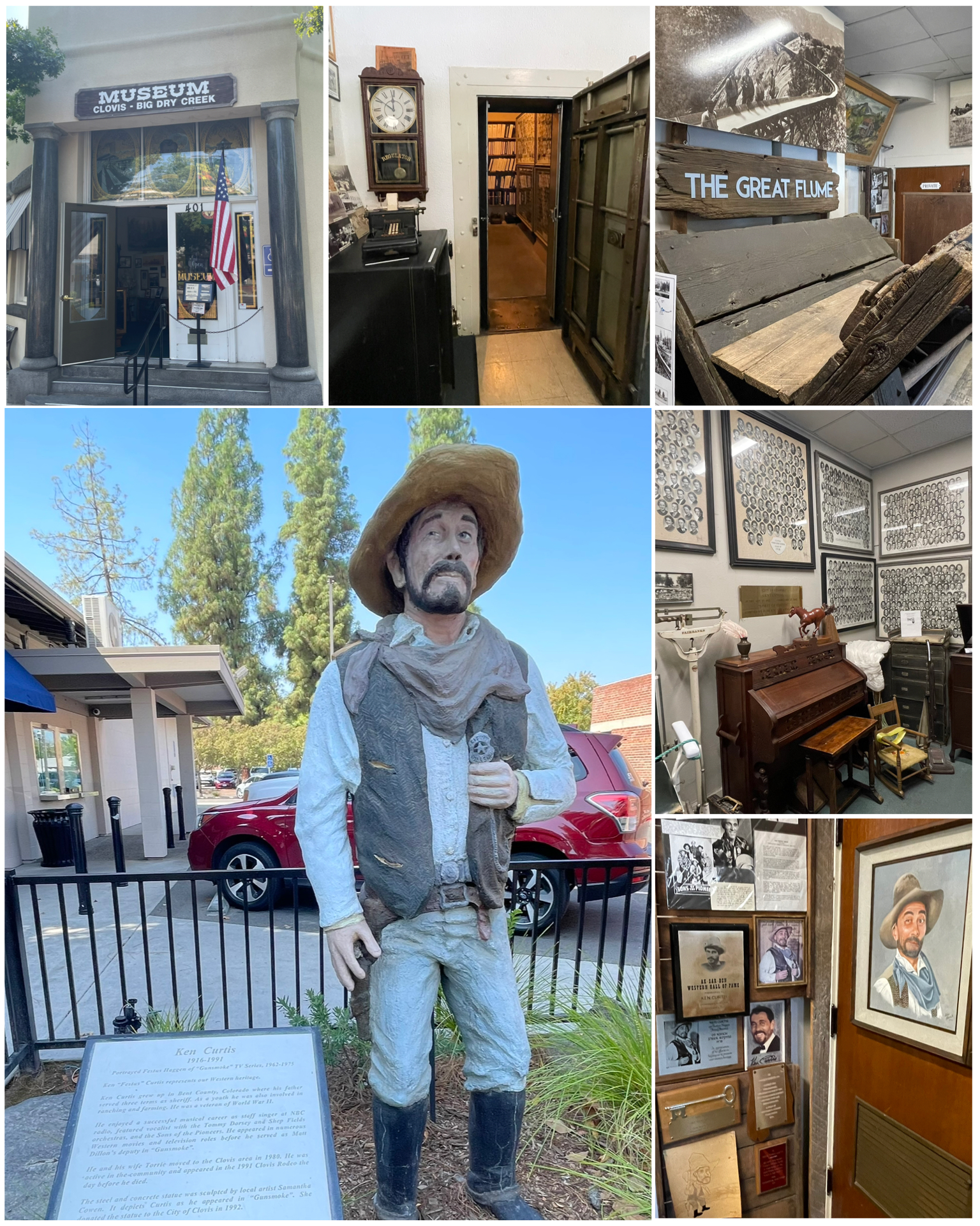 Downtown Clovis was really impressive. Located about 7 miles from downtown Fresno, this town of 120,000 celebrates its heritage as a frontier town known for its lumberyard and sawmill, while today being a popular rodeo town. I visited the downtown Old Town Clovis historic district where I would find their historic museum. The museum is located in what was once a bank, that was built in 1912, but failed in 1925 after having lost all its money to a 1924 robbery. To this day, the town does an annual recreation of that famous robbery. What was First State Bank later served as a judicial/municipal court office until 1981, and was then leased to the Clovis-Big Dry Creek Historical Society and became the Clovis Museum. It was an awesome regional museum and had lots of historical artifacts. One that was particularly noteworthy were the local highschool class pictures that began with a photo of the four kids that graduated from the first class circa 1903, all through the decades that followed. There were also pieces of the Great Flume – a purpose built water driven transport that moved lumber. The V-type flume (at right, top right) was made of cedar planks, 16 feet long and 16 inches wide by 1 1/2 inches thick joined together at a right angle to each other forming a “V”. It operated from 1894 to 1914, and was the third longest flume in the world. It began at Shaver Lake some 5,275 feet above sea level, then dropped 4,900 feet as it descended along its total length of 42 miles and ended in Clovis. Simply Amazing! Also featured in the museum (at right, bottom right), and outside with a life-size statue, was local celebrity Ken “Festus” Curtis – a cast member of the hit TV series Gunsmoke. Overall, a really well done museum.
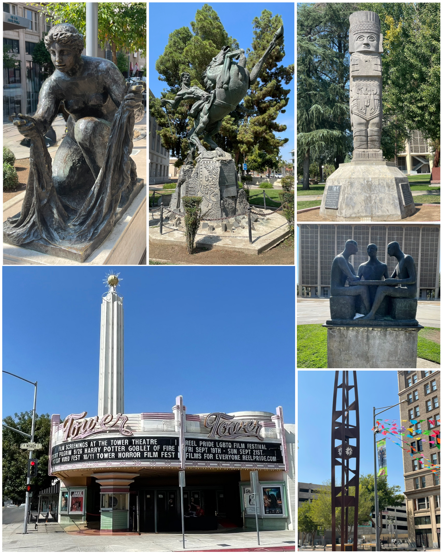 Next I went into Fresno to check out a few Roadside attractions. First up was this classic neon covered art deco movie theater from 1939 (at left, bottom left). Named Tower Theater, apparently both the marquee and the tower are lit up with neon at night. Very cool! Next was this statue depicting epic Armenian folk hero David of Sassoon (at left, top center). Sitting in front of the Fresno courthouse was this bronze statue titled “Brotherhood of Man Memorial” (at left, center right). This piece, made in 1968 by artist Clement Renzi, pays tribute to a radio show named “Forum for Better Understanding” crated by a priest, a rabbi, and a minister, and featured open discussions of social and religious topics. Surely something we could use these days! Also on the grounds near the courthouse was this replica of a 900 AD god of the Toltecs (at left, top right), and was a gift from Hidalgo, Mexico in 1980. Also nearby, though not on the Roadside list, was this clock tower (at left, bottom right) that I thought was kinda interesting. Last up is this Pierre Auguaste Renoir sculpture titled La Grand Laveuse” (at left, top left), of a woman hand-washing laundry. From 1917, it is one of only six original bronze castings, and the only one in the series that is out in a public street corner free to be touched and rubbed. Certainly the first Renoir that I’ve had my hands on!
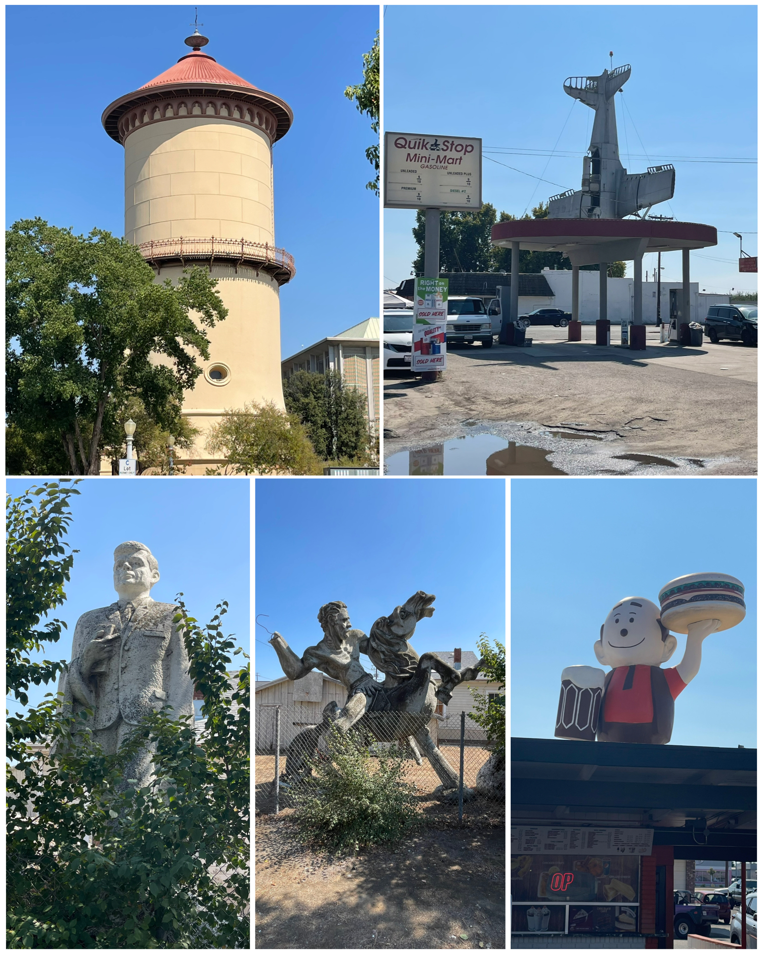 There were more things to see in and around Fresno. This old water tower in downtown (at right, top left) stands over 100 feet high and was built way back in 1894. It was designed to to mimic a tower located in Worms, Germany, and contained a steel tank holding upwards of 250,000 gallons. It was drained in the mid 1960s, and the base converted to a city repair shop for paring and water meters. That space later became a visitor center in 2000 until 2022, and today is host to a café. Out in the residential section of town, in a somewhat overgrown yard, was this statue of President John F. Kennedy. Produced from clay in 1964 by artist Varaz Samuelian, this 16-foot, 18-ton behemoth was created to represent the grief the artist felt from the president’s assassination in late 1963. It was created in hopes to be commissioned for a bronze casting. Sadly, it never was and now this demo version sits deteriorating in the elements. Interestingly right next to this statue was another demo – this one of David of Sassoon. As we now know from the paragraph above, that one was apparently successfully commissioned. In nearby Caruthers, CA was this old gas station having what looks like a fighter plane crashing into it. The story goes that the Vultee Trainer from WW II was purchased as surplus by a local farmer who only wanted the engine to use as an upgrade to one of his crop dusters. Having no use for the rest of the plane, he sold it off which eventually led it here as an attraction piece. Definitely different! Last up in this batch was a visit to this iconic Papa Burger character from A&W Root Beer fame from the 1960s. Sitting atop the roof of a classic drive-in burger joint in Selma, CA, it seems to have maintained its pristine look.
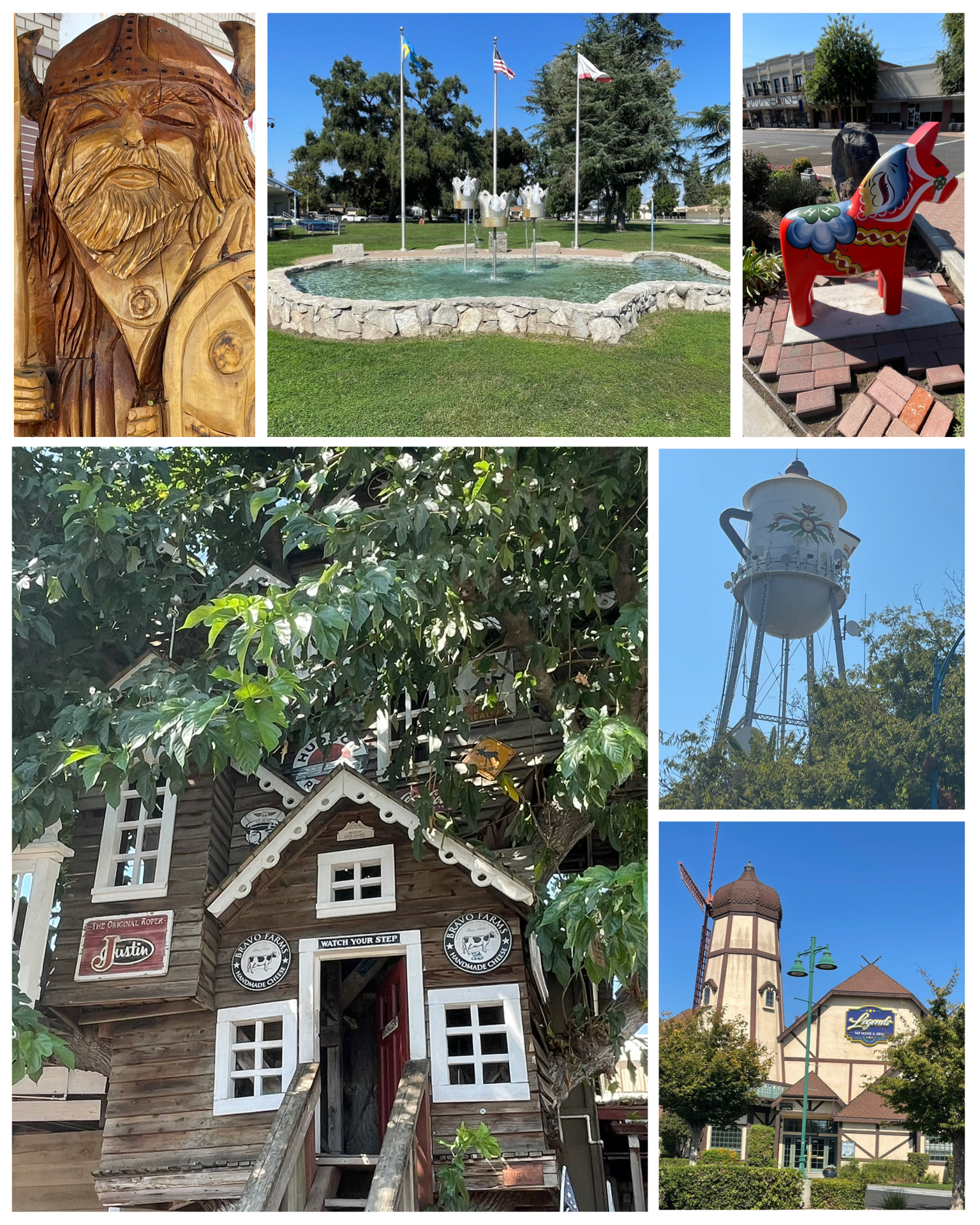 My Roadside adventure continues here in Selma where I visited this dutch-themed windmill building (at left, bottom right). It once was part of a chain of Dutch-themed restaurants called Anderson’s Pea Soup – which features, what else, home made all natural split pea soup. The chain originated in Buelton, CA in the mid 1920s, and several in the chain are still in operation – mostly along the I-5 corridor. This one in Selma, however, is no longer part of the chain, and has reportedly been home to several other restaurants over the years. Cool building though! Next, I visited the Bravo Farms Cheese Factory in Traver, CA. Besides picking up some freshly made blocks of various cheeses (pairs well with my collection of California wines), I wandered around this very popular attraction. Besides the vast storefront and the ability to watch the cheese making process through observation windows, the outside also had a small animal farm and this really cool seven-story tree house free to explore (at left, bottom left). The entrance to the tree house was a bit small for me, so instead I enjoyed watching kids wander through all the levels. I’m sure my grandkids would really enjoy playing in this tree house. My next stop takes me to the Swedish themed town of Kingsburg, CA to check out a few items. In Memorial Park, this US-styled fountain (at left, top center) known as Three Crowns Fountain, has three metal crowns on poles, dumping water into the pool shaped like the lower 48. Also in Kingsburg was this giant water tower in the shape of a Swedish Coffee Pot. The origins of 122 foot tall tower date back to 1911, while the coffee pot mod occurred in 1985. In historic downtown, there were several other Nordic themed items including one of many Dutch Dala horse statue (at left, top right), and this really cool wood carved Viking statue (at left, top left). Really nice visit to a very cool town.
Bakersfield, CA
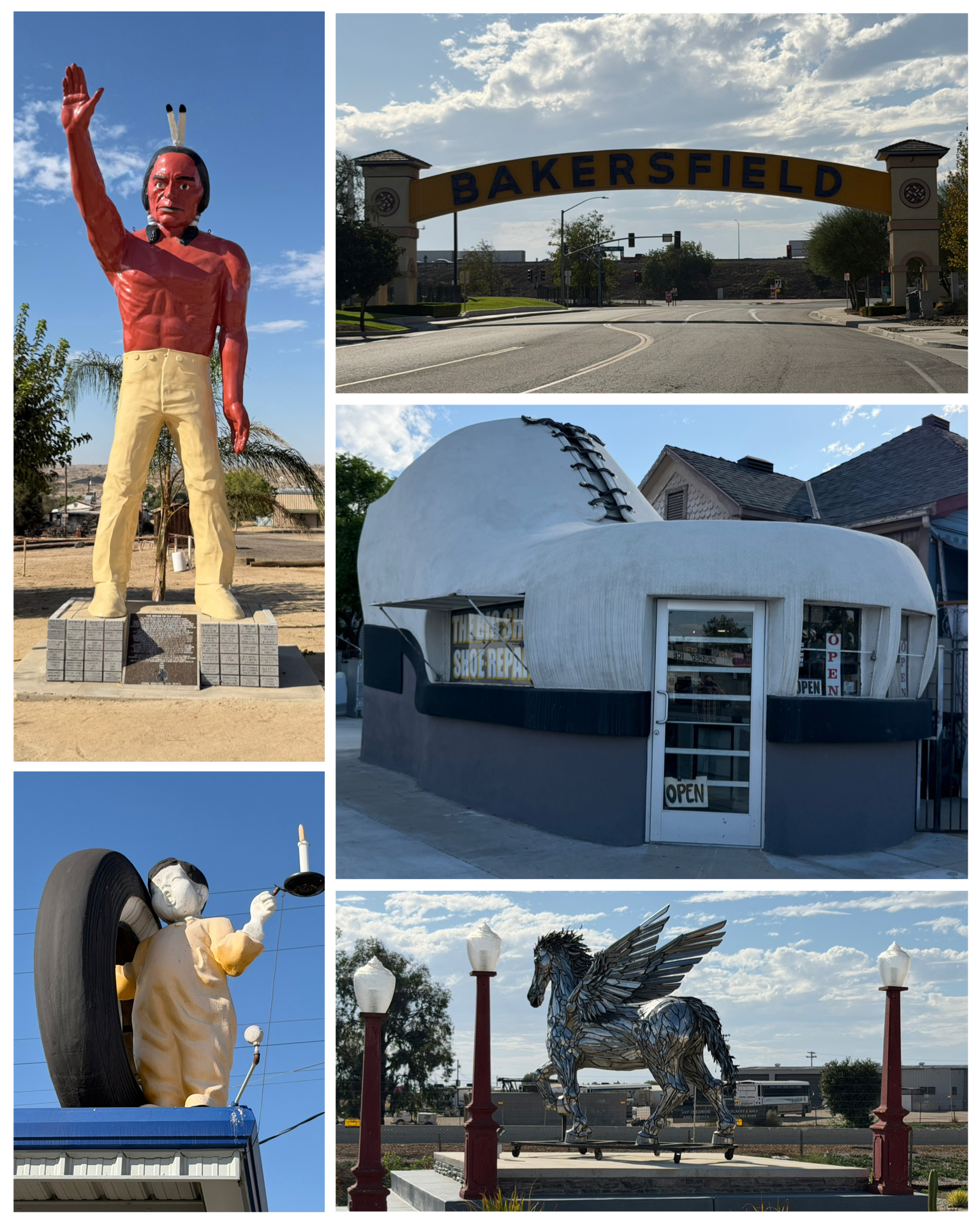 My next stop is quick a 2-night stay in Bakersfield – just over 100 miles to the south. There were a handful of Roadside oddities in downtown, so I headed out there on my one and only tourist day. This town name archway used to span old Rt 99 as part of a hotel. The hotel, and the sign, were torn down in 1999. Country music legend Buck Owens purchased the demolished rubble, and used some of the pieces of the old arch as parts of a new build on another street adjacent to his Crystal Palace nightclub. A large red Indian muffler-man statue stands tall at Ethel’s Old Corral Cafe. In the 1960s, he started out as a mascot and attention grabber for the Barnes Big O Tires store. The store closed in 1972, and the statue spent the next 17 years lying behind a school. A cowboy was the next owner where he vowed to restore it and place it on his ranch. When the ranch was later sold, the cowboy donated it back to the city and organized funding for its now grand footing. Quite the life! This 2020 sparkly silver pegasus sits outside of a forklift dealership, the owner of which actually created this piece as a project. Pretty tallented! Dating back to 1906, the 6 foot tall advertising mascot “Fisk Tire Boy” sits atop the roof of a tire company. This piece was apparently trademarked in 1914, and a few of them still remain. I’ll have to see if I can find any more. Last up, this shoe repair shop in the form of a shoe was certainly entertaining. Big Shoe Repair still operates out of this circa 1947 building in the form of a big shoe. Hard to believe folks still have their shoes repaired in lieu of just replacing them. Who knew!
Acton, CA
 Some 100 miles to the southeast, in LA County, is my next quick stop in Acton. I really did not plan this stop very well as there was tons of things to see in this area, not the least of which were two of my nephews. Based on the fact that I only had one tourist day, and my nephews were approaching 2 hours away with traffic, and that it was the middle of the week where theyy would be working, dealing with kids and school, and otherwise dealing with everyday life, I decided to skip connecting with them on this trip. Besides, I’ll be back in the area next year when I do my Rt 66 run, and plan to stay for 2 weeks at each stop. So, I’l have plenty of time to see them then. Sorry about that guys!
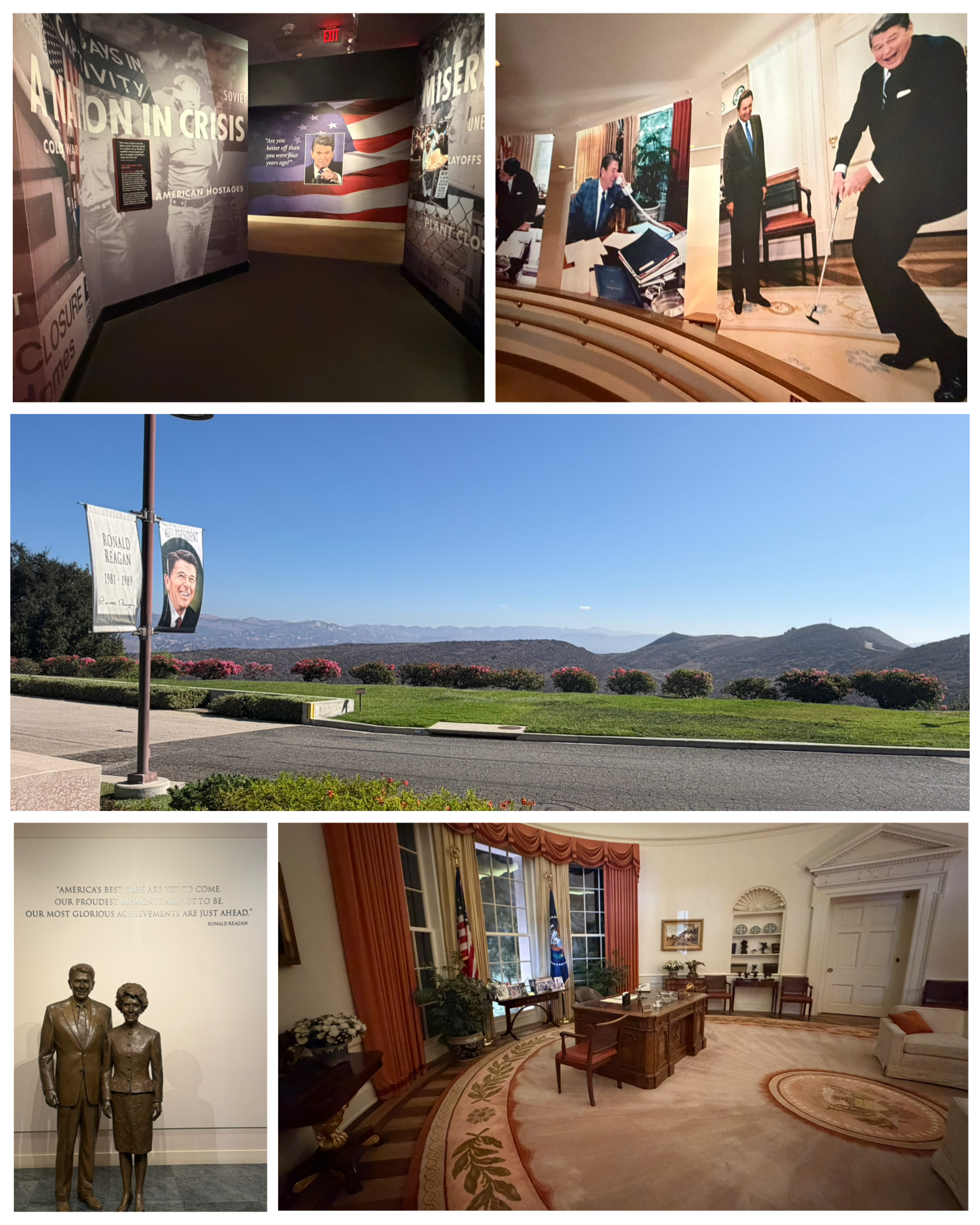
So, with the one and only day that I had available to see a few sites, I reviewed my options and picked a few places to check out in the greater Los Angeles area. First and foremost, I wanted to visit the Ronald Reagan Presidential Library. And oh wow was it an absolutely amazing place. I’ve been to a few other Presidential libraries, but this one definitely tops them all! First, the location. Sitting high atop the hills in Semi Valley, on a sprawling 100 acre campus, this site offers some of the most amazing views of southern California all the way to the Pacific Ocean. It was just a breathtaking building location. Among the many, many artifacts and dioramas showcasing the life and times of Ronald Reagan from childhood through his governership and ultimate election as our 40th President, there were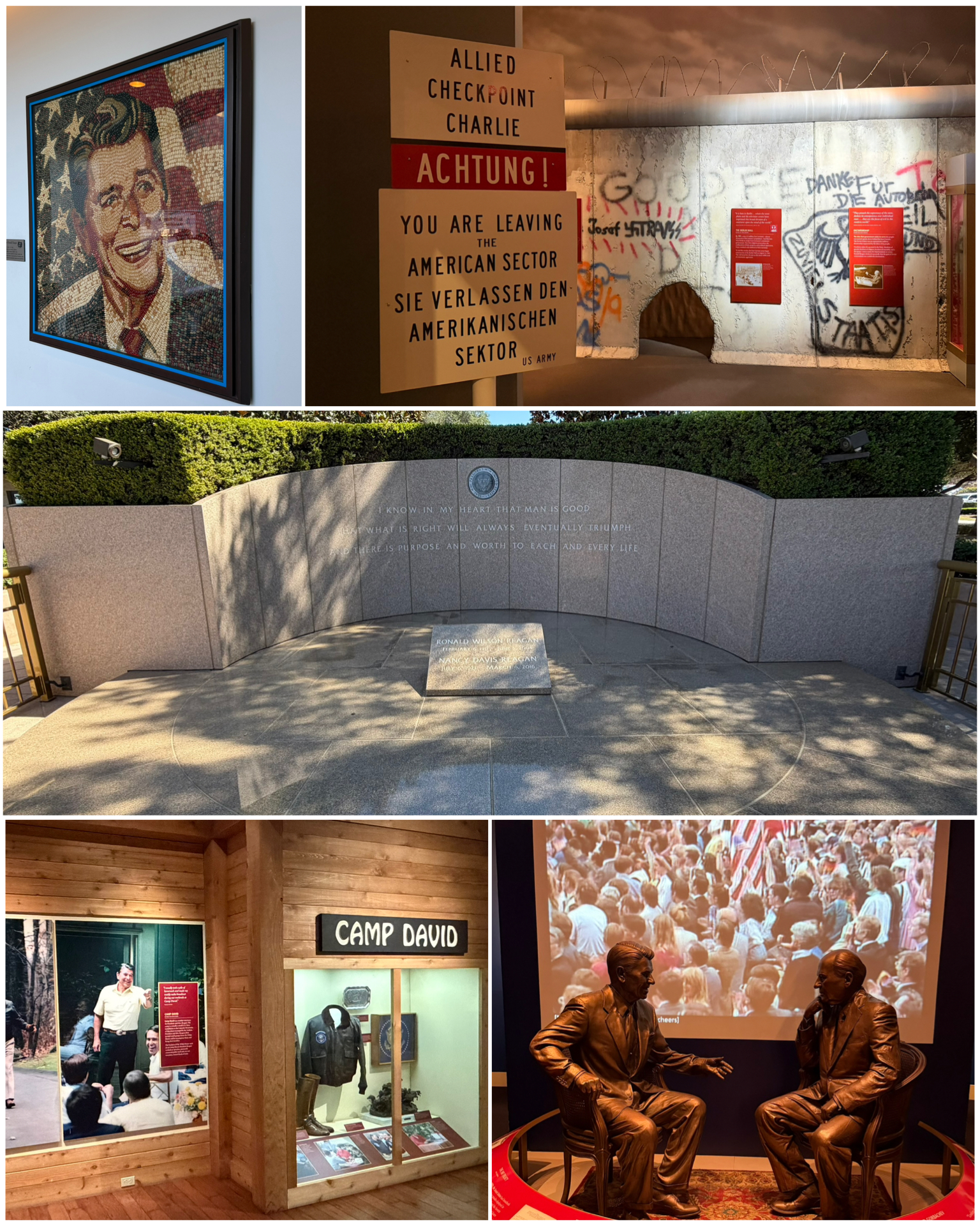 several displays that were quite special. Of course, the recreated oval office was a most noteworth highlight during the tour. As each President is able to decorate the oval to their liking, President Reagan, inspired by his love of the West, added earthy colors, western art including a collection of bronze saddles, and, of course, a jar of jelly bellies for his desk! It was a really nicely done recreation.
Other notable exhibits included the framed photo of Reagan – made entirely of Jelly Belly Jelly Beans (at right, top left). This was the work of artist Peter Rocha who used upwards of 10,000 jelly beans to create the 4ft x 4ft portrait. Truly amazing! Then there was the recreation of the events of the Cold War and Checkpoint Charlie, along with the many summits held between the two leaders of the US and the Soviet Union, all leading to the speech in West Berlin on June 12, 1987, when President Ronald Reagan famously called on Soviet leader Mikhail Gorbachev to “tear down this wall!”. There was also exhibits of time spent in Camp David – the presidential country retreat. And of course, both President Reagan, and his wife of 52 years Nancy, are buried here on the grounds of the library (at right center).
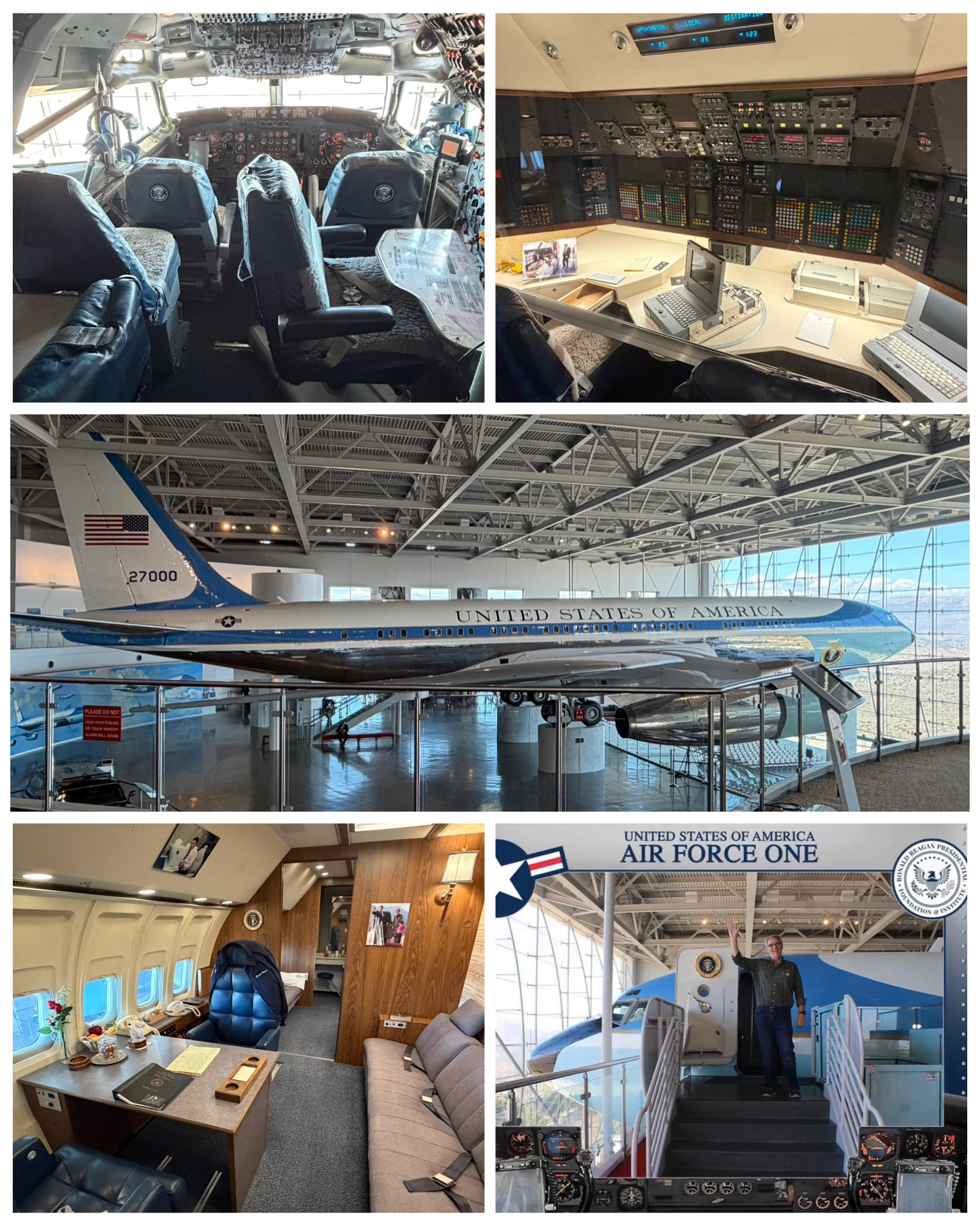 Of all the things to see here at the library, seeing, and actually walking through the official Air Force One aircraft. This Boeing 707 aircraft with tail identifier SAM (Special Air Mission) 27000, was first delivered to the Air Force in Aug 1972. It would be President Richard Nixon who first took to the air in Feb 1973. This aircraft then went on to serve presidents Gerald Ford and Jimmy Carter. But it was Ronald Reagan who used it most during his tenure as President. I have seen other presidential aircraft before – notably the circa 1962 Boeing 707 known as SAM 26000 that resides at the National Museum of the Air Force in Dayton, OH. However, it was only seen from the outside as inside visits were not allowed (at least when I was there). But not only did I get to walk through this aircraft to see the President quarters with desk and couch, along with the communications center (at left, top right), and cockpit (at left, top left). I even had my
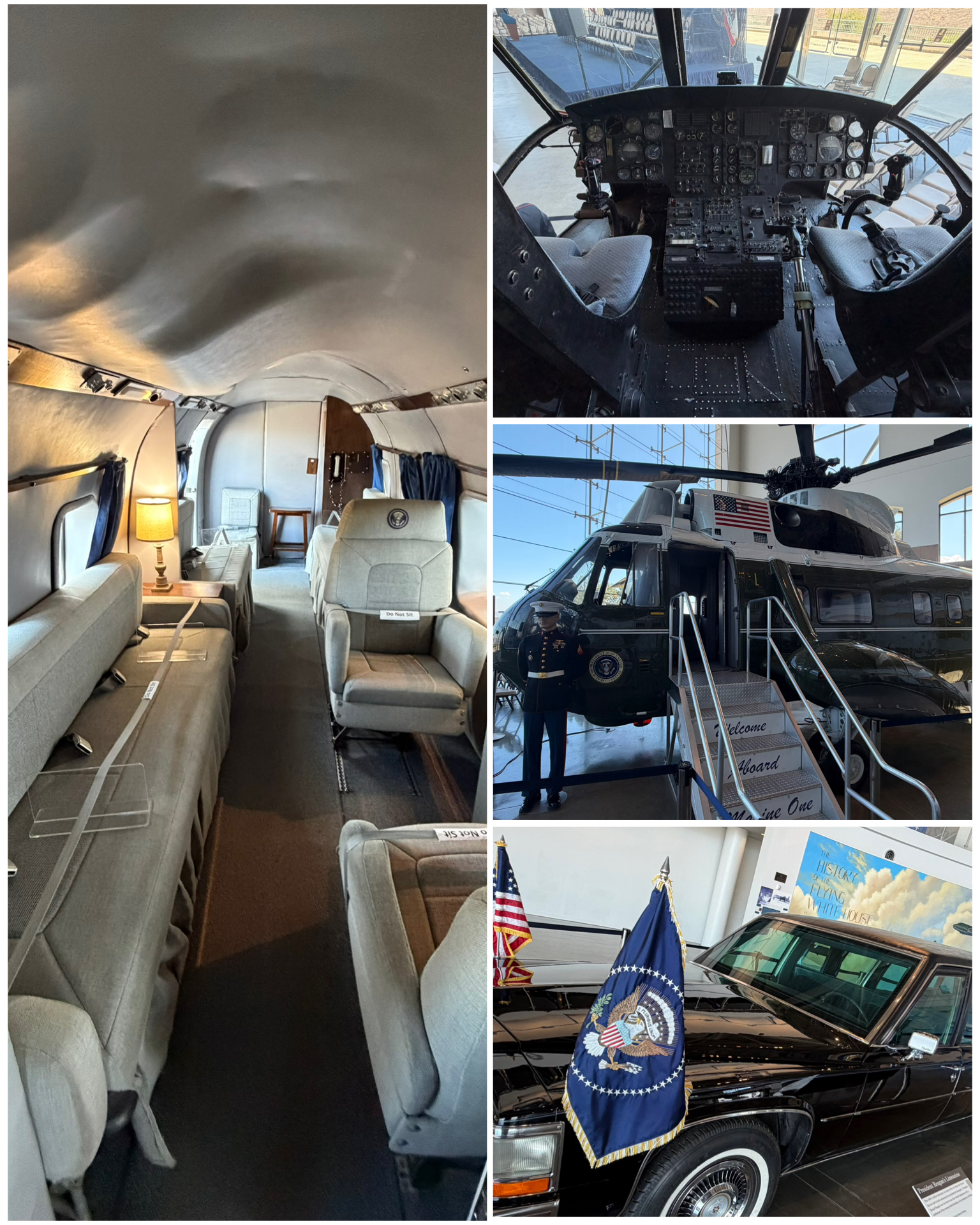 picture taken as I boarded and waved to my fellow citizens (at left, bottom right). How amazing it was to see the inside of this plane!
Not to be outdone, I also saw and was able to walk through Marine One – the marine operated helicopter that shuttles the President short distances – like from the White House to Andrews AFB. While it looked comfy with its heavily padded leather chairs and long couch, I was a bit surprised by how small it was inside. But, I guess as helicopters go, it was probably considered quite roomy and luxurious. I had a picture taken there too while boarding, but it was stupid as they made me hold a dumb Marine flag in the picture. If you really want to see it, you can do so by visiting the photo library via the link at the bottom of the blog. Lastly, there was also several presidential motorcade vehicles that were present in this display area, including this flagged 1963 Cadillac limousine. There were also Secret Service Suburbin follow-up vehicles, as well as a BMW motorcycle which was actually used in escort duty for “Operation Serenade” – President Reagan’s funeral. I spent several hours in this Presidential library, and thoroughly enjoyed every minute of it. Highly recommended if you happen to be in the LA area.
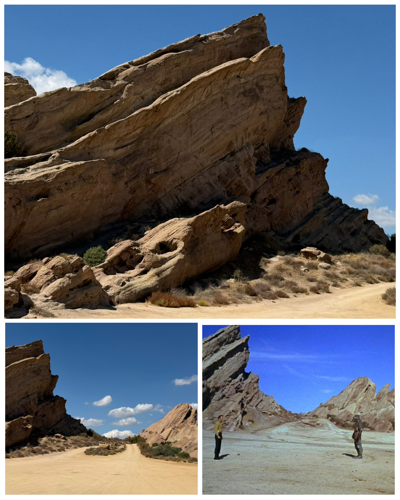 On the way back to the campground after visiting the presidential library, I made one other stop to visit this iconic location. Vasquez Rocks County Park is a 932 acre nature park along Escondido Canyon Road in Agua Dulce and is a favorite hiking and rock climbing spot featuring unique geological rock formations. Making this more unique, the area has been featured in many movies and TV shows. This very spacey rock formation has been the backdrop in several Star Trek TV episodes, in the movie Bill and Ted’s Bogus Journey, in the movie Austin Powers, as planet Vulcan in the Star Trek 2009 movie reboot, and The Flintstones movie from 1994. From the pictures I took (at left, top and bottom left), you can clearly see the exact same background as that of the original Star Trek TV series in the “Arena” episode (at left, bottom right) where Captain Kirk battled the Gorn commander. Sure looks like an match to me! These crazy rock formations were formed by rapid erosion and the result of sedimentary layering and seismic uplift. about 25 million years ago, and then later exposed by further uplift activity along the San Andreas Fault. That whole process sure produced some really unique rock formations!
Twentynine Palms, CA
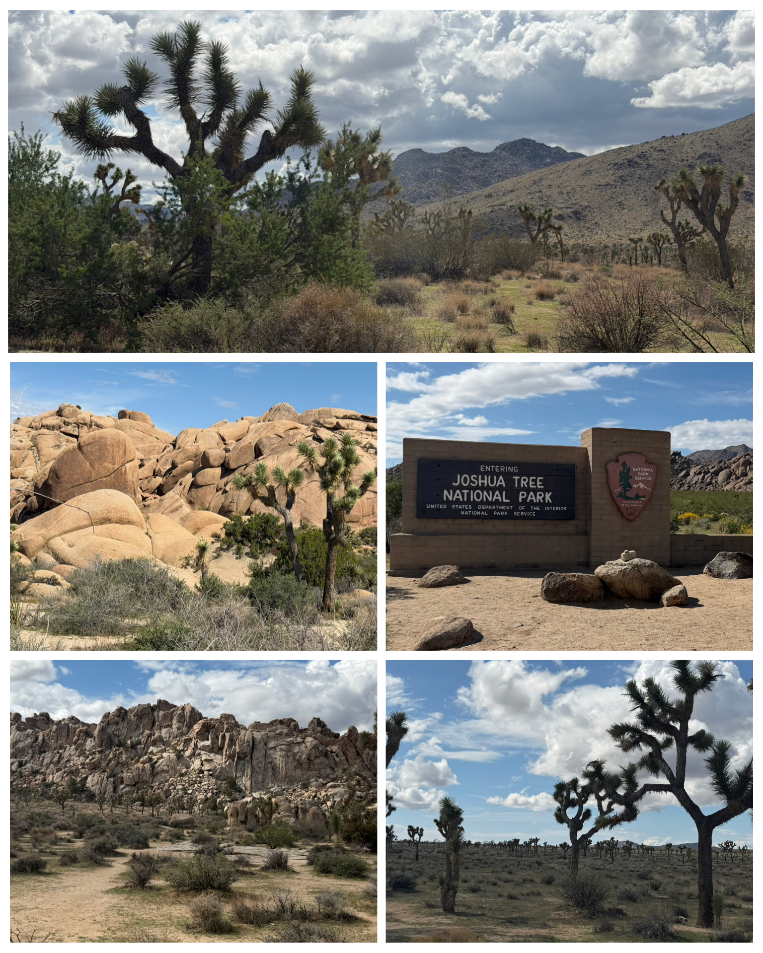 Twentynine Palms was the launching point to visit my 8th and final National Park during this year’s epic nomad adventure. Joshua Tree National Park’s northeast entrance was a mere 7 miles from the campground along Rt-62 – 29Palms Hwy making for a quick and easy starting point. Park blvd runs about 30 miles through the National Park, then ends right back on Rt-62 in the town of Joshua Tree – 15 miles down to the west. Easy in, easy out! This 795,000 acre park was first designated a National Monument in 1936, then transitioned to a National Park in 1994 via the congressional approved California Desert Protection Act. Portions of the Mojave Desert and the Colorado Desert are contained within the park. Driving through the park was really breathtaking! The very unique, special, and endemic Joshua Trees are notably thriving and abundant here in the park. Also present were lots of interesting and scenic rock formations. I really fell in love with this particular tree, and started to look around local garden centers and such to see if I might be able to purchase one to bring back to Florida. Well, that was until I found out these are heavily protected. In California, it is illegal to import, export, take, possess, purchase, or sell any western Joshua tree without authorization from the California Department of Fish and Wildlife. Well, so much for that plan. Besides, I later learned that buying one via this legal process will run you upwards of $300-$400 per foot in height. So, a relatively small three foot youngin would run more than a grand. Well, no thanks!
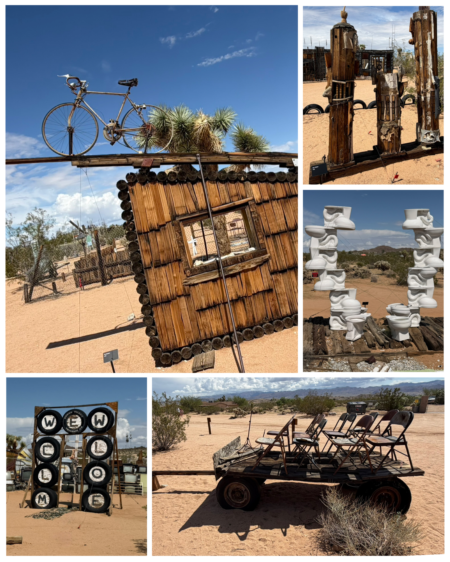 Besides checking out Joshua Tree, I did find that there were lots of interesting Roadside attractions here in the area. First up was a visit to the Noah Purifoy Outdoor Desert Art Museum of Assemblage Sculpture – aka a desert yard in the middle of nowhere filled with junk art. Noah Purifoy, a respected artist from Los Angeles, moved to the Joshua Tree area in 1989, and for the next 15 years, filled his 10 acre trailer homestead with over 100 art pieces. Sadly, he tragically died in 2004 while sitting in his wheelchair when his trailer went up in flames. But now over 20 years later, his artistic work lives on, and is a popular tourist destination. It is however, well off the beaten path, located off a dirt road out in the boonies. But it was a an interesting stop and old Noah certainly did have an eye – obscure as it may be. I found the piece featuring a collection of toilets to be most interesting (at left, center right), as was his interpretation of a gas station (at
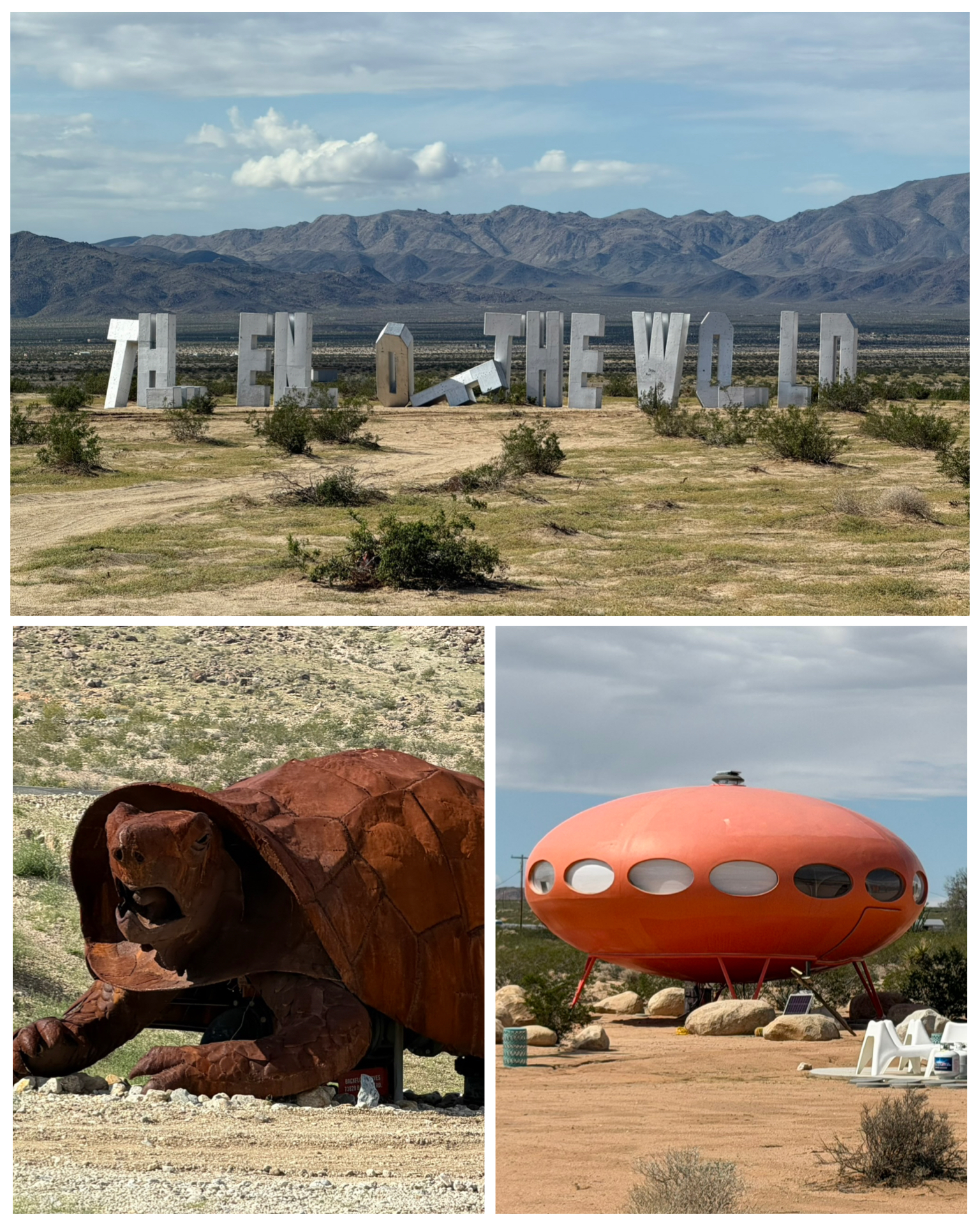 left, top right). I have no idea of the meaning of the folding chairs on the trailer though.
While I was in the area, I took the opportunity to check out another local Roadside attraction that was nearby. A Futuro house (at right, bottom right) sits out in the desert – fully restored and used as a sort of Air-BNB. The Futuro house is a circular, prefabricated house designed by Finnish architect Matti Suuronen in the 1960s as a portable ski chalet, notable for its UFO-like shape and fiberglass-plastic shell construction. First launched in 1968, fewer than 100 were built globally, and only about 60 remain today. This particular one was relocated from its previous home in Wisconsin here to the Joshua Tree desert, and certainly does appear to be in very nice shape. I sure would love to have seen the inside! Out to the east from 29 Palms on Rt-62 is this End of the World sign (at right, top). These large, tall letters along the desert landscape – some standing and some fallen over, was setup by artist Jack Pierson in 2022. Designed to sort of mimic the famous Hollywood sign, this desert wonder offers proof to visitors that they have in fact been to the end of the world. Last up, a couple of large rusty desert tortoises flank the parking lot of the Tortoise Rock Casino. Pretty cool looking!
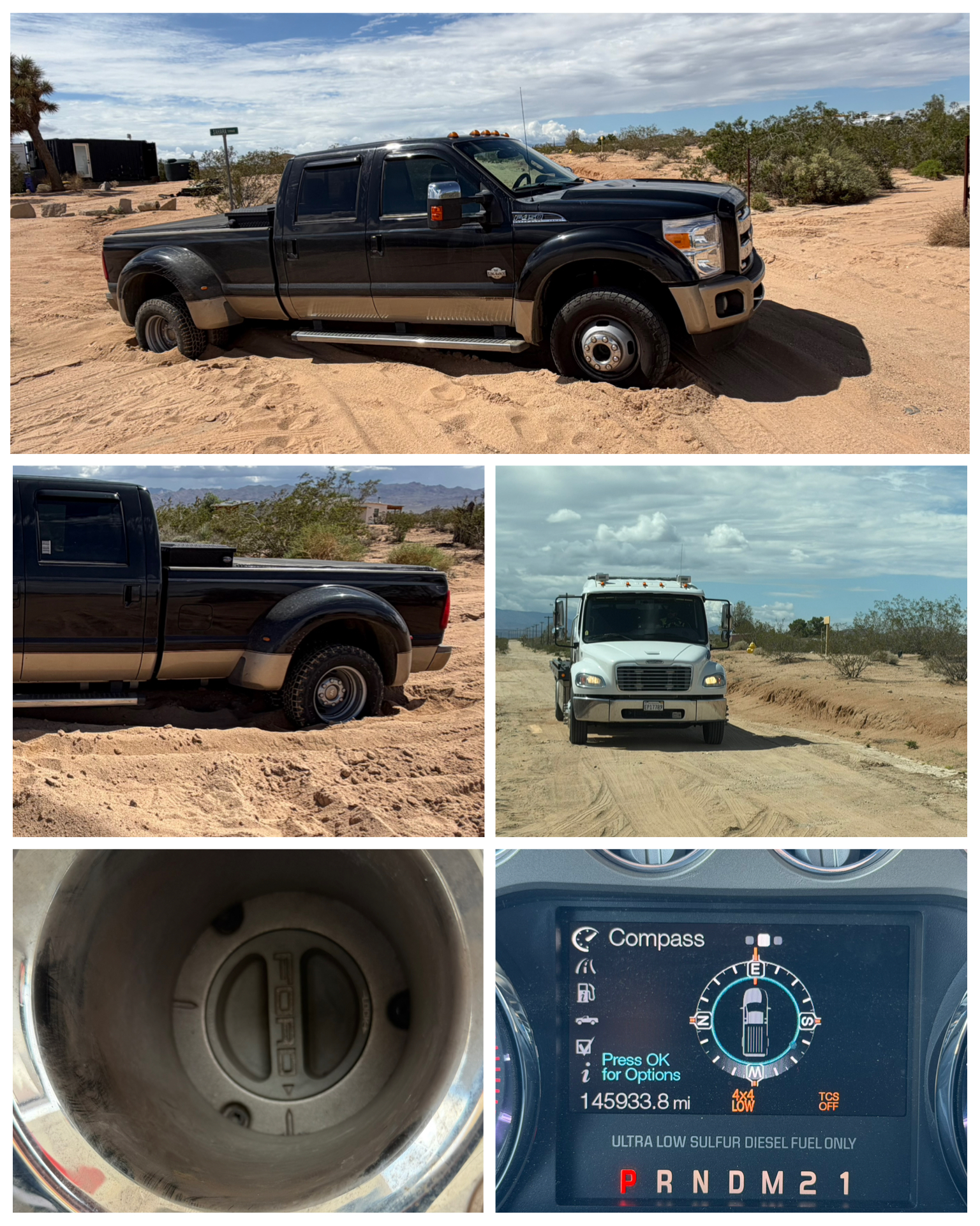 Ok – I’m going to pause this blog for just a minute to offer my very own Public Service Announcement (PSA). As I was out visiting these Roadside items in the Joshua Tree and 29 Palms area, I found myself migrating from the safety of paved roads, onto what was mostly hard packed dirt. In fact, while visiting the End of the World sign, there was a small hard packed parking area right off the highway, with warnings not to drive all the way out to the sign due to soft sand. Then, when I visited the outside art museum, then the Futuro house, those too were all accessed via dirt roads. They seemed fairly passable, so I didn’t think much of it. However, as I was driving away from the Futuro house, I came to a “T” intersection – requiring a left or right turn. Directly in front of me was what looked like a giant sandbox, with loose and deep soft sand. Well, I have a big powerful truck, high off the ground, and figured I could blast my way through this without issue. WRONG! As soon as the truck hit the soft sand, it was going nowhere! I tried alternating between forward and reverse in an attempt to rock myself out of the sand. No such luck! Then I thought, well I have 4 wheel drive, so I merely need to switch it into that mode, and I should pop right out. So, I hit the 4WD switch, confirmed I was in 4WD on my display (at left, bottom right), and tried again. Same result – but I was only digging myself deeper in the sand. So after a few minutes of vocalizing several expletives, I came to the realization that I needed to call for a tow out. About an hour later, my rescue truck arrived (at left, center right). We got out, chatted for a bit, then he asked me to show him how the truck was acting when I attempted to get out. I did so, and he quickly realized I was not in 4WD – despite my dash indicator saying otherwise. Apparently, these model year Ford trucks have to be actually moving for the 4WD to actually engage. Since I was stuck in the sand and not moving, I really was not actually in that mode. Located on each of the front tires inside the hub is a manual switch that when turned into the Locked position will in fact manually put you in 4WD. He locked both my wheels, and asked me to try it again. Wouldn’t you know it – the truck pulled right out! So, that ended up being a $135 lesson on how 4WD works on these older model Ford trucks. Hopefully, this PSA will save someone else from having to pay for that same lesson! Needless to say, I was a bit frazzled and a lot pissed from this misadventure, so I pointed the truck back in the direction the campground and called it a day. No more dirt roads for me!
Needles, CA
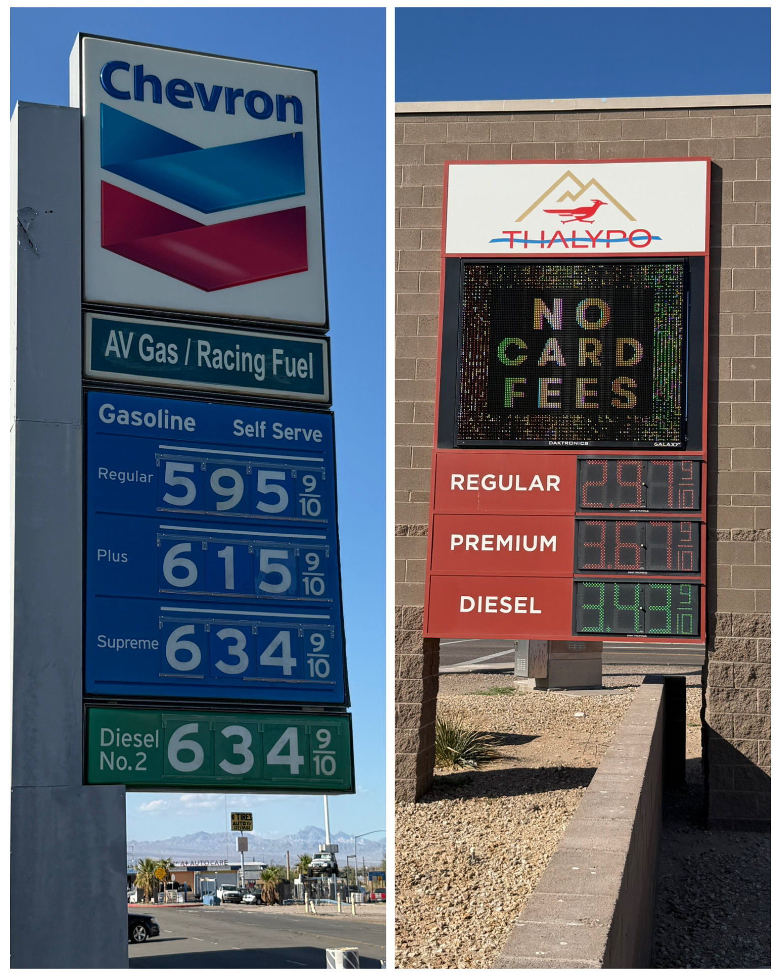 My last stop in California, and the beginning of my mad dash to the east begins here in Needles. It also marked my entrance to I-40, which I will pretty much follow for the next 1,500 miles or so all the way to Memphis, TN, where I will then begin heading south towards the home base in Florida. From here, all my stop overs will be short – arriving one day, spending two nights, then back on the road the next morning to do it all over again. So, I really only have a single full free day if I wanted to explore. But the reality is, I-40 runs parallel to a large portion of Rt-66, which I plan to fully explore during my nomad adventure next year. So, I’ll likely limit my tourist activities on my free day, and rather catch up on some other projects that have been on my list. However if anything particularly interesting pops up, I will share it here in the blog. Take this for example. Before I leave on a travel day, I always fill my truck with deisel fuel topping it off to its full 65 gallon capacity. In doing so, I always use a couple of phone apps to help find the cheapest fuel in the area. This particular diversity of costs was stark, and so reflective of the crazy gas prices found in California. Take for example this Chevron station – located in Needles, CA about 2 miles from my campground. Diesel fuel cost $6.35 a gallon. That’s insane! Compare that with this station – located a mere 1 and a half miles further, across the Colorado River into Arizona, and the exact same product is $3.43 per gallon. How in the hell is that possible? Almost half the cost! Well, needless to say, I so happy to be out of California, and frankly the entire Pacific Coast region. Most definitely a great place to visit, but these exorbitant fuel prices are not sustainable. No wonder there are so many electric vehicles (EVs) out there. Much easier to financially justify when factoring in those fuel prices.
Williams, AZ
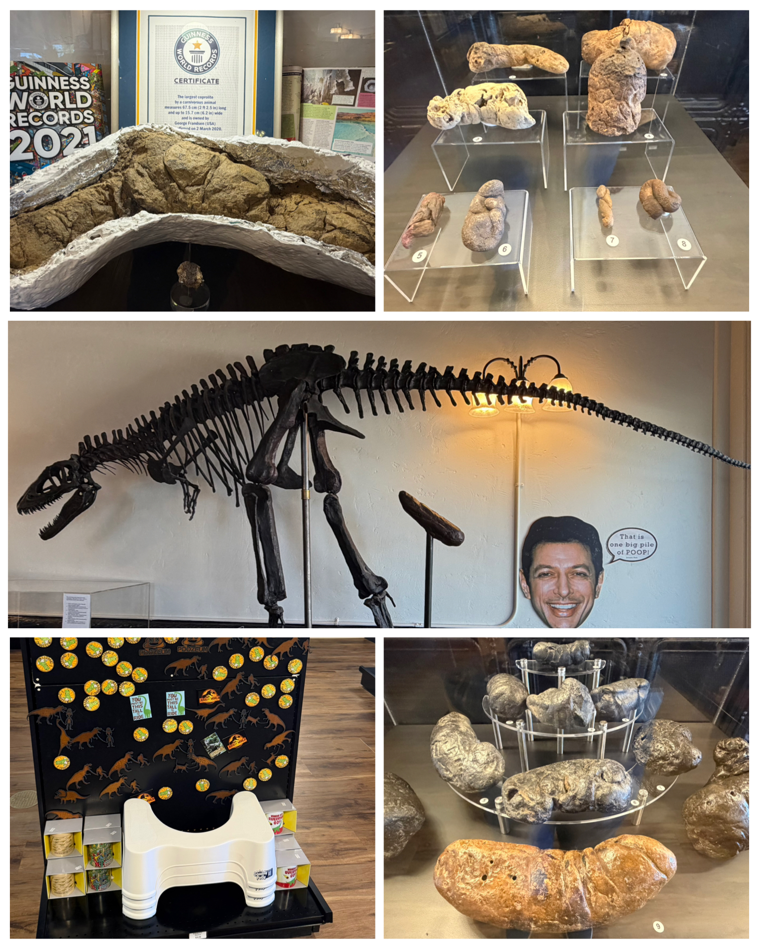 My first official stop outside of California was to Williams, AZ. I’ve actually been to this area before – back in 2023 when I explored portions of Rt-66 around Winslow and Flagstaff. And again, I plan to be back here next year, having extended stays along the route that will allow for a full and complete exploration. But, I did take a peek at the Roadside app just to see if there was anything new and noteworthy to check out on my single free tourist day. It turns out there was – this gem, the Poozeum! Originally Founded in 2014 by George Frandsen, featuring thousands of authentic fossilized specimens from around the world, this is the world’s most extensive collections of fossilized poop – or as its officially called, coprolite. What was once a mobile travelling museum has evolved into a permanent home here in Williams, AZ in 2024. Nothing says welcome to the poop museum than this giant dinosaur skeleton releasing a poop from what would be his backside (at left, center). All different kinds, colors, shapes, and sizes of poop are on display. They even have the Guinness World Records largest poop (at left, top left) weighing in at 20.47 pounds, 26 inch long, 6 inch wide (ouch!) estimated to be about 70 million years old. This was a really fun stop, and never would I have thought that I’d enjoy experiencing dino poop up close. They of course had a full service gift shop with all sort of poop related products. I found the inclusion of the Squatty Potty (at left, bottom left) to be appropriate and ingenious. It was George himself that was on hand to welcome visitors, and I had the opportunity to have a very interesting chat with him. Thanks George for sharing your very unusual collection with us curious folks.
Final Thoughts
 As noted, I’m working my way to the east back to the home base. From my present location, I’ll have 11 quick stops of 2-night stays each, as I make my mad dash to Florida. While I’ve had another incredible year touring this amazing country, I usually get weary
 around this time from all the extended travel. It will be welcoming to get back home and settle down for the winter so I can regroup and recharge while planning next year’s epic adventure. So the next blog will feature the final stops along my journey, detailing what limited tourist activity I might be engaging in. But knowing me, I’m sure I’ll use the Roadside app to find some interesting places to visit and write about. I’ll also begin to plan for my end of travel year wrap-up edition, that details and highlights some of the statistics from the journey, as well as sharing a peek into the collection of souvenirs I’ve gathered along the way. Till next time, be well and safe travels! Epilog: I usually end my blogs with a little cartoon or meme for the enjoyment of my readers. This time, I wanted to choose one that was relative to the theme of this trip – notably the high cost of fuel. I couldn’t decide between these two that I found, so I figured I’d just use them both. Hope you enjoy them!
I only show a sampling of my adventure pictures here in the blog, and do so mostly in collage format for brevity and ease of reading. If you want to view an album containing individual full fidelity and hi-res images of all my travel pictures related to this specific blog, click the image below. Enjoy!

Great blog as always. I don’t know how anyone can afford to live in California, but it sure is a beautiful place to visit. Nice going in the sand, you would think the weight of your truck would have given you caution. Enjoy your return to home base and looking forward to seeing you when your back.
Yea, I agree. CA is a nice place to visit, but way too expensive to live there. As for sand trap, I did give it caution – just not enough humph to get me through it. 😂. See ya soon!
I have been to a few of these places and also liked them all. Your blog takes me to the places I have missed. Thanks for that.
Glad you are enjoying my extra sightseeing. Unfortunately, next year might not bring you as much new sights since you have already completed Rt 66. I’ll have to try and find some new things you have not seen.
Wow some really cool places Bruce! The Reagan library looks amazing. And you know I love the dog stuff. So cool having the water fountain flow into the helmet. Very clever indeed.
The Festus statue brought back memories. Gunsmoke was my Dad’s favorite show. He hardly ever missed an episode.
Bet you are glad you don’t have to deal with those crazy west coast gas prices any more😮. We complain here if it reaches $3.
Safe travels home over the next two weeks. Stay out of the sand traps!!!😉😊
Glad you enjoyed the blog – some of which brought you some fond old memories. And yes, I’m sooo glad to be out of the west coast and their crazy prices. My last couple of fill ups have been sub $3.00 per gallon. So refreshing! See ya soon