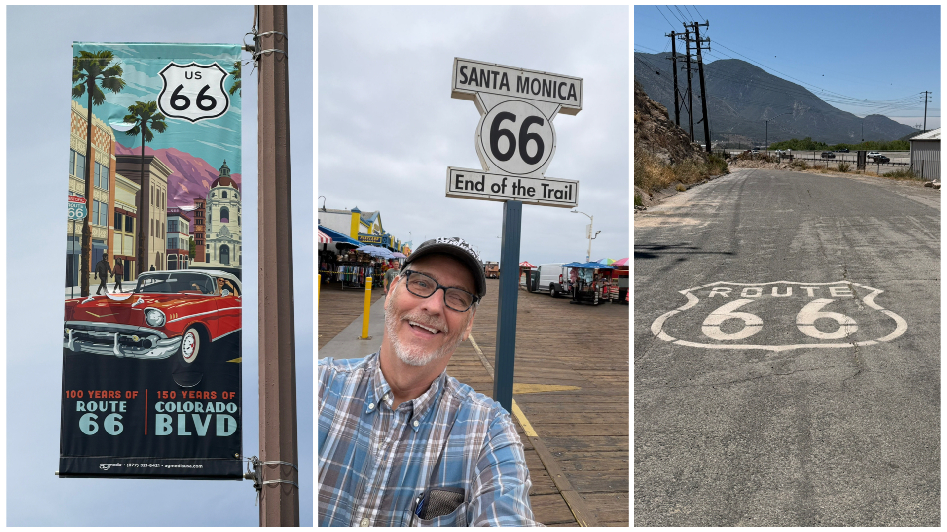
And so it begins! After a couple of additional quick 2-nite stops, I finally arrived at the starting point of my Rt 66 adventure. Despite the sign indicating this to be the end of the trail, for me, it is just the beginning. I’m working my way backwards from the traditional direction, starting in Santa Monica and ending in Chicago. So what follows are details of those two additional stops, followed by the start of the Rt 66 trip. So, let’s get to it!
Salome, AZ
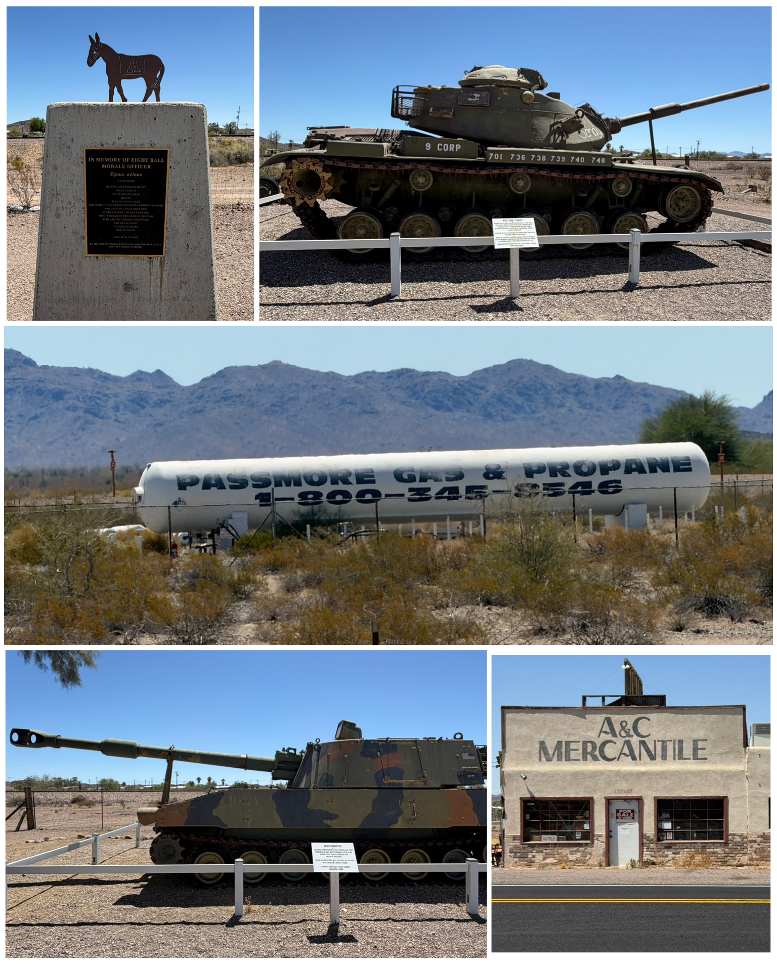 My first stop in this leg of my adventure takes me to Salome, AZ – home to just over 1,000 residents in east central AZ. Nothing notable to see in town, but there were a few Roadside items of interest nearby. First up was this gas company with an interesting name – Passmore Gas & Propane! A giant tank at its company headquarters adequately boasts the point. Catchy name! Next I drove into the small town of Bouse, AZ – a town even smaller than Salome, having a population of just a smidge over 700. What it lacks in residents is somewhat made up in military history. Bouse is home to what was once Camp Bouse – a former World War II US Army tank training center. Besides tank training, a super secret project was explored here whereby super bright lights were developed and tested mounted on tanks that would be used to blind and confuse opposing tanks in nighttime warfare. In the end, it didn’t work out that well and the project was scrapped. A cool little roadside attraction has several tanks on display, and tells the story of the camp. In particular, a memorial for Eight Ball, a camp burro mascot that drank beer from a helmet with the soldiers, but was shot and killed when it was caught eating the underwear of the local nurses that was drying out on a line. Hmmm – must have been the beer! Across the street was the A&C Mercantile building that was built in 1904. It started life as a general store, then a post office was moved into the back room. During Camp Bouse days 1943-44, it served as the local PX. All in, it served the local community from 1916 thru 2018. That’s a pretty good run! It is also rumored that General George Patton slept in that A&C Mercantile building.
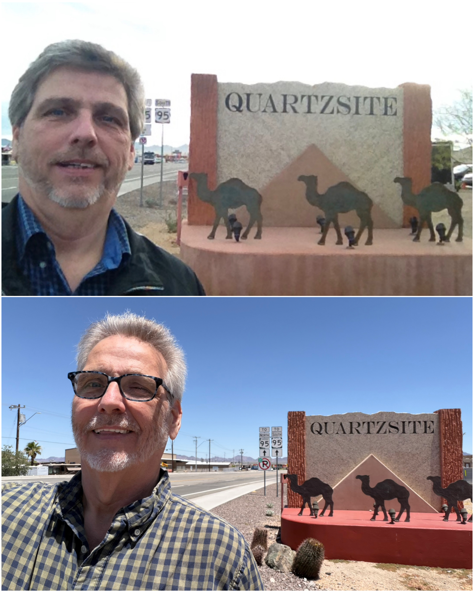 I was only about 30 miles or so away from Quartzsite, AZ so I had to go there. As seen from this “then and now” photo, this was a place I had been long ago. That top photo was from 2014 – back when I was a bit younger, and seemingly a bit heavier. I had remembered that photo I took so many years ago, and thought it would be fun to recreate it. Same spot, 12 years later. Quartzsite is a well known town among RVers as it is a popular destination during the winter months. In the summer off season, this rural dusty desert stop with only a single stop light in town has a population of around 2,400. But between Nov and Mar, RVs of all sorts and sizes roll in by the thousands raising the winter population to nearly a million people. Much of the camping is boondocking out on BLM (Bureau of Land Management) land with no water, power or sewer hookups. The BLM owns thousands of acres surrounding Quartzsite, and most of it is open to free dispersed camping. Even at that price, I certainly would not be interested. I like my hookups! Anyway, the winter season also brings in eight major gem and mineral shows, a big tent RV show, and several swap meets all over town. When I was here in 2014, it was in January at the height of all the winter activities. This time, I arrived in June, when all of the RVers had already left. Definitely a different kind of town vibe between the two seasons.
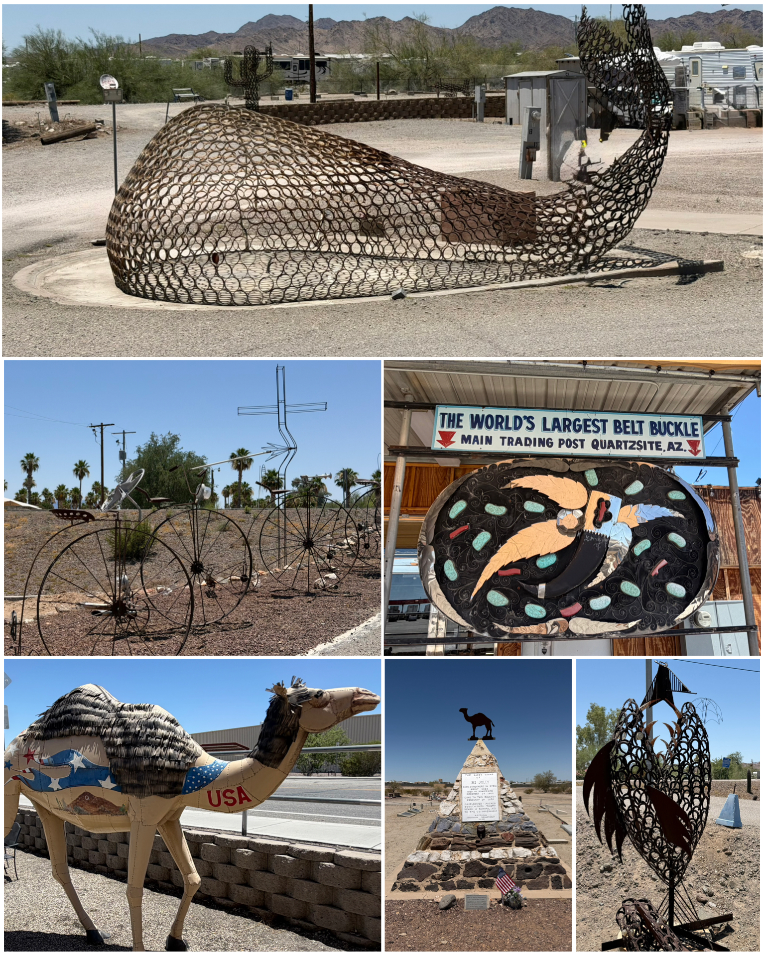 There were a few Roadside items to check off during this visit. First up was a visit to a local campground that features tons of metal art. A giant whale made of metal rings (at left, top), to a fish made from horseshoes (at left, bottom right), to several high rollers made from various tractor parts. It was a really cool stop with lots of things to see. Also in town is the proclaimed largest belt buckle (at left, center right) that sits in front of a local jewelry store. Good thing there was a sign, as it was not obvious that this was a belt buckle. Last, I visited the local cemetary to see Hi Jolly’s tomb (at left, bottom center). It was Secretary of War Jefferson Davis who in 1856 had the bright idea of importing flocks of camels to transport people and goods across the desert southwest. 70 camels in total were imported, along with a Syrian caretaker named Hadji Ali – or Hi Jolly to his American friends. Soon thereafter, the American Civil War broke out, and Davis became President of the Confederate States, leading the Confederacy in the war. With his attention elsewhere, the camel project was abandoned and the camels set free in the desert near Quartzsite to fend for themselves. Hi Jolly stayed in Quartzsite living into his 70s. The locals were so fond of him, that upon his death, they created this pyramid tomb for his burial. As for the camels, they apparently did pretty well for themselves, long outliving Hi Jolly and Jefferson Davis. Their last reported sighting was in 1942.
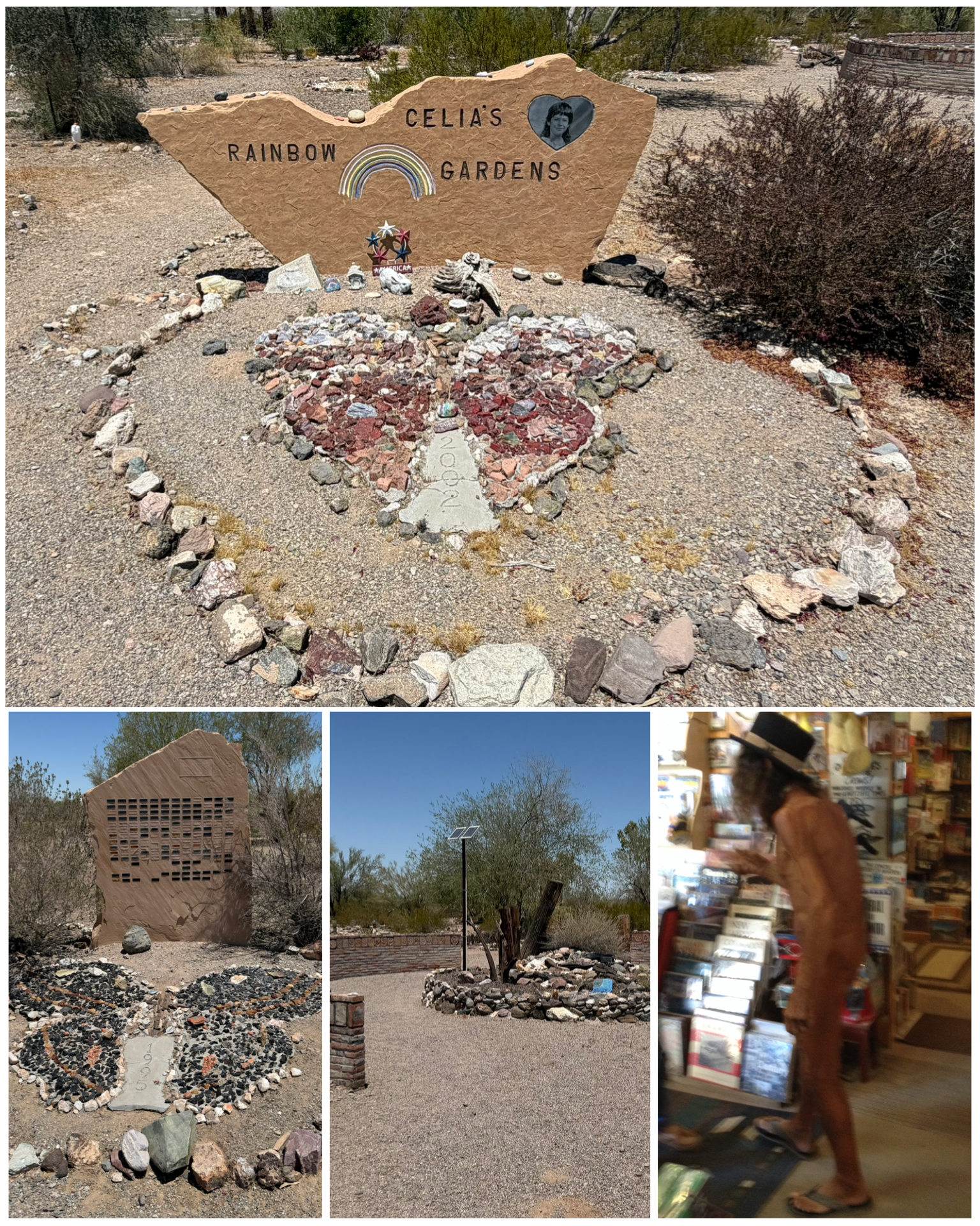 The other place I visited in Quartzsite was Celia’s Rainbow Garden. Celia Anne Winer was not quite nine years old when she died in 1995 of a viral heart infection. The local townspeople, along with many of the RVers, created this rock garden in her honor. A very beautiful place to honor this young girl. What I didn’t know when I visited the garden, and only learned after doing a bit more research on her for this blog, was that Celia was the daughter of famed musician and Quartzsite icon Paul Winer. Paul was a piano playing boogie-woogie singing character who performed up and down the east coast from 1965-1990, wearing as little clothes as legally possible. He later moved to Quartzsite AZ to live with his wife and daughter. He opened a bookstore which later became known as the naked bookstore as Paul would wander around wearing nothing but a sock – and it was NOT on his foot. I visited the bookstore when I was here in 2014, and got a chance to see Paul. He was swamped with other visitors so I didn’t get a chance to actually talk with him or take a selfie with him. Best I could do was this side view picture (at right, bottom right). He was definitely quite the character. He passed away only a few years later. You can see a video of him doing his music thing wearing nothing but what appears to be a jock strap HERE. If you want to see and hear a bit more of his musical stylings, check out this longer video HERE including his classic big time hit “F’em If They Can’t Take a Joke” at the 1:14:00 mark. A two hour documentary titled “Sweet Pie: The Paul Winer Story” was released in 2018, but so far I’ve not found any way to view it. I’ll keep looking.
Indio, CA
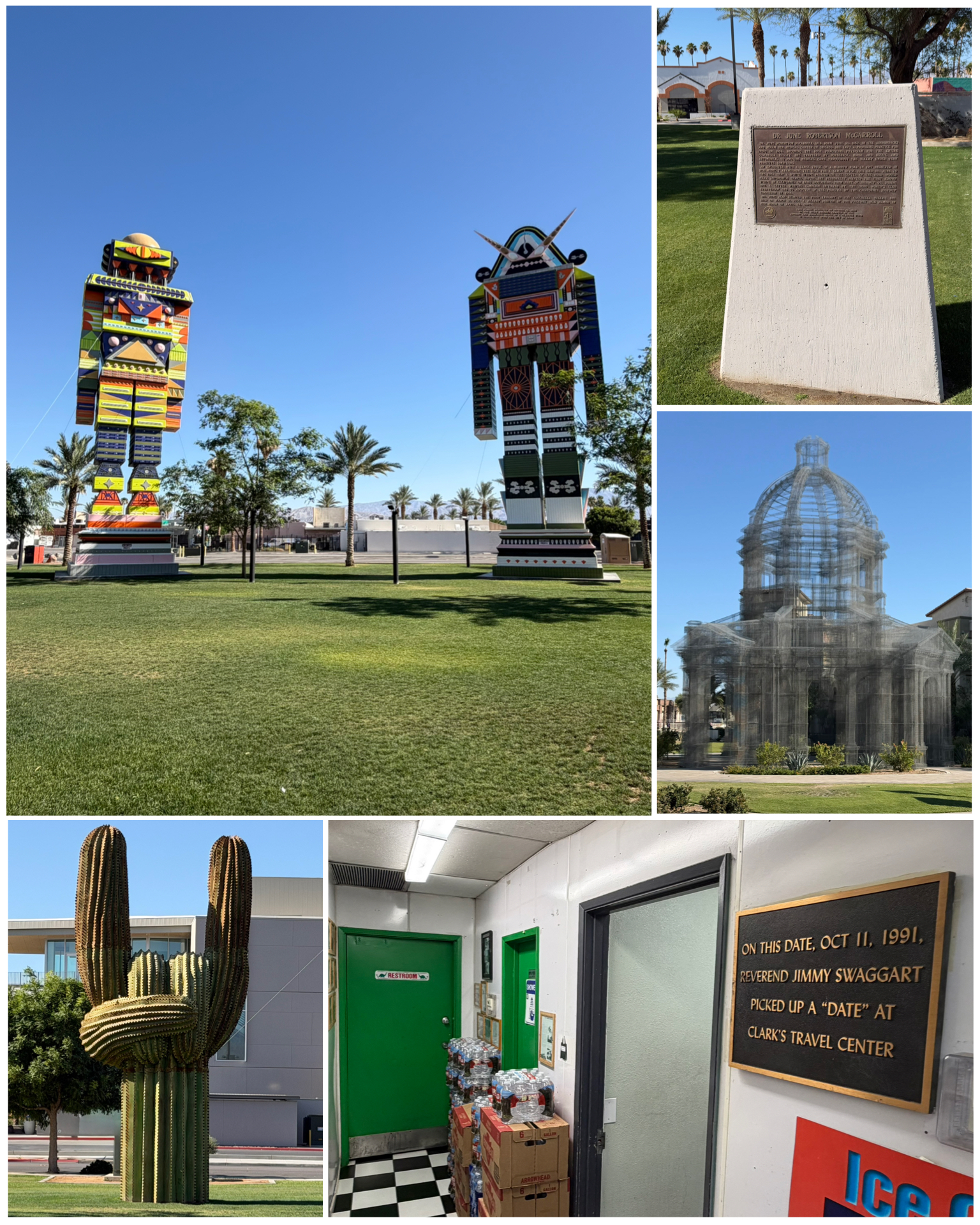 Well, I finally made it to California! My first stop here takes me to Indio which is located in the Coachella Valley of Southern California’s Colorado Desert region. And wow was it hot! Temps were in the low tripple digits each of the two days I was here. Sure made my new AC’s work hard, but they did the trick and kept me comfortably cool. Indio is a pretty good size city, with a population exceeding 89,000, and home to the famous annual music festival known as Coachella. It was definitely an artsy town, with several cool Roadside items to check out. First up are these giant 65 and 75 feet tall robots (at left, top left) created by a Sri Lankan artist for the 2023 Valley Music and Art Festival. They were ginormous! Across the way in the same park was this cactus hand shaped thing (at left, bottom left) proclaiming “Rock On”! That was also pretty cool. In a little park in a business section of town on Indio Blvd was this historical marker (at left, top right) which credits Dr June McCarroll with the idea of painting a center line on a road to promote safety. It was 1917 when a truck nearly collided with Dr. June forcing her and her Model T into a ditch. It was that event that led her to personally paint that stretch of road with a center line to keep vehicles on their appropriate side. California highways reportedly adopted the practice, and it spread from there. Next, you might think my camera went crazy, but this 54 foot tall cathedral (at left, center right) is actually made of wire. It was built
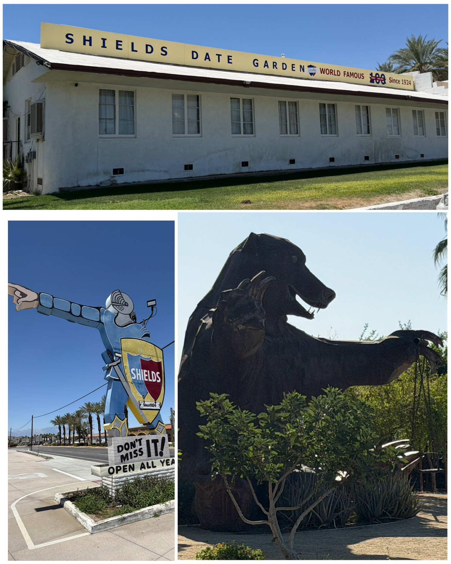 for the 2018 Coachella festival, and has had a home here since. Last up was this crazy bronze plaque (at left, bottom right) that adorns the wall next to a gas station restroom that memorializes the location and day in 1991 when televangelist Jimmy Swaggart picked up a prostitute and was thereafter arrested. Wow – what a legacy!
The other thing Indio is known for is dates. Not the mating ritual variety, but the sweet yummy fruit. This date palm orchard and processing center was established back in 1924 by Floyd Shields and his wife Bess. Over the decades he even bred a number of his own varieties that remain exclusive at Shields to this day. To promote his business, he did lectures on date cultivation which later evolved into a slideshow with accompanying narration that he titled “Romance and Sex Life of the Date” – a slightly updated version of which still runs in the store theater. It was very entertaining and educational. The climate of the Coachella Valley apparently provides an ideal environment for date palm cultivation and reportedly is responsible for upwards of 95% of the nations date production, with Arizona taking up the remaining 5%. Sheilds is also credited with creating date crystals and date sugar – dry blends of the dates used in cooking. They even make and sell date milkshakes at the store. I passed on that, but did leave with a collection of various date varieties to sample in the coming days and weeks. Yummy! Last up in town was this giant 24 foot tall bear that was made for the 2015/16 Coachella festival. It holds a porch swing in one hand, and a disco ball in the other, and now resides in a small park in downtown Coachella.
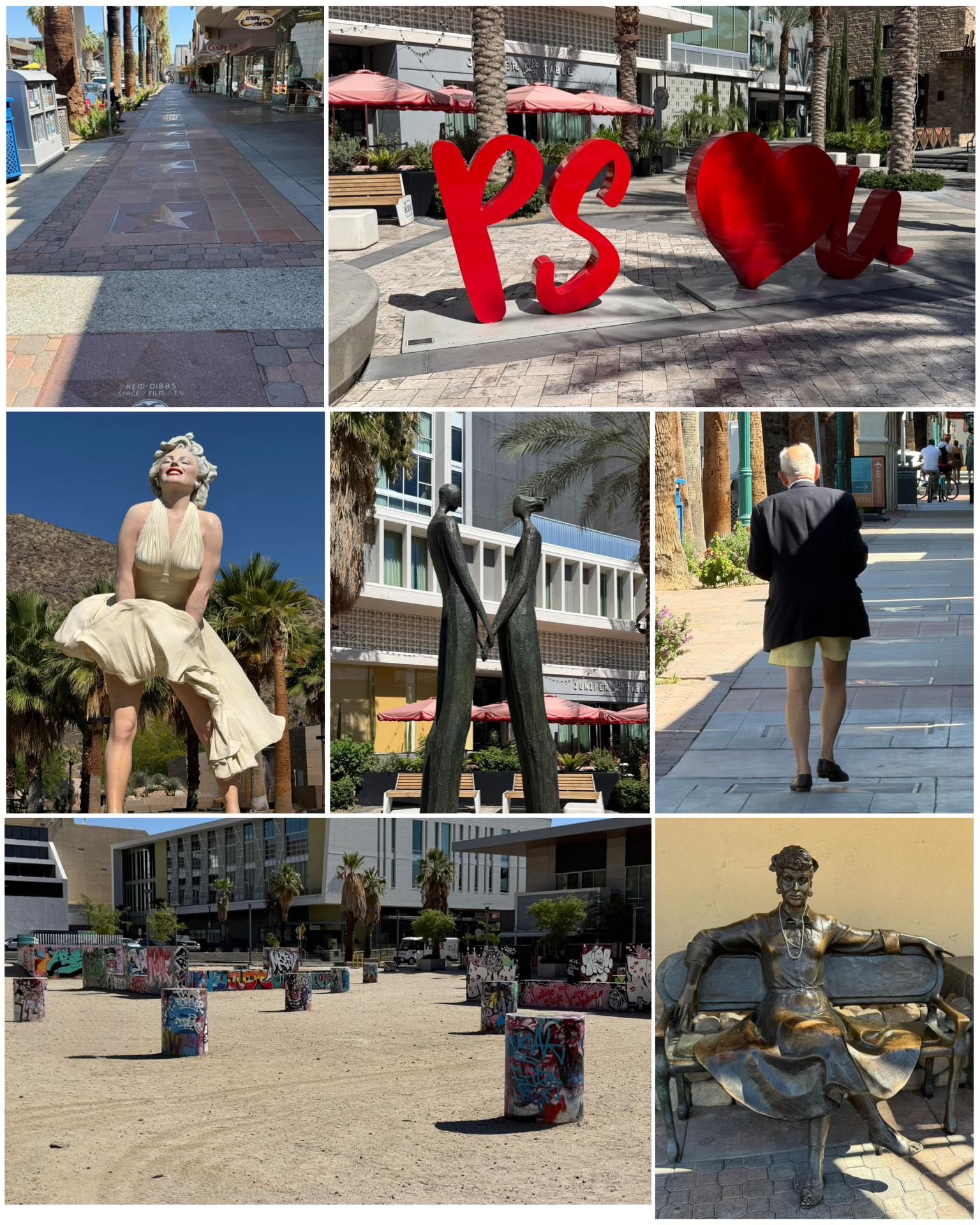 The last town I visited in the valley was Palm Springs. This place is a well established winter getaway for the rich and famous, with lots of celebrities having homes here. Lots and lots of million dollar plus homes. It also had a Hollywood vibe as well, with lots of TV and movie star references. They even have their very own Walk of Stars in downtown (at left, top left). A massive 26 feet, 17 ton famous stance of Marilyn Monroe can be found here, along with a park bench with none other than Lucille Ball sitting at the ready for a photo op. Across the street from Marilyn is a place called the Graffiti Yard (at left, bottom left) – a place for would be tagging artists to show off their work. I came across a few other cool art pieces as I walked around town, and also happened to notice this chap (at left, center right) walking down the sidewalk. It appears he might have forgotten to put on something before he left the house! Too funny!
 A few other items of interest include the house (at right, top) which sits on a quiet cul-de-sac on Ladera Circle. What makes this place special is that Elvis Presley paid $21,000 to lease the house for 1 year from 1966 to 1967, and intended to marry Priscilla there. Apparently, next door neighbor and Hollywood columnist Rona Barrett got wind of the event, and to avoid the would be media circus, Elvis decided to move the wedding to Las Vegas. They did return here to the home after the wedding, and spent the next several days honeymooning and presumably consummating their nuptials. In fact, it was exactly 9 months later when daughter Lisa Marie was born. Coincidence? The home was open for tours for several decades later, and has recently changed ownership a few times. Most recently it sold for a reported cool $7.3M – considerably lower than the $9.3M original asking price. Elvis connections have been removed and tours have since been shut down. There were lots of construction trucks there when I happened to swing by, so apparently there’s still lots being done to the home.
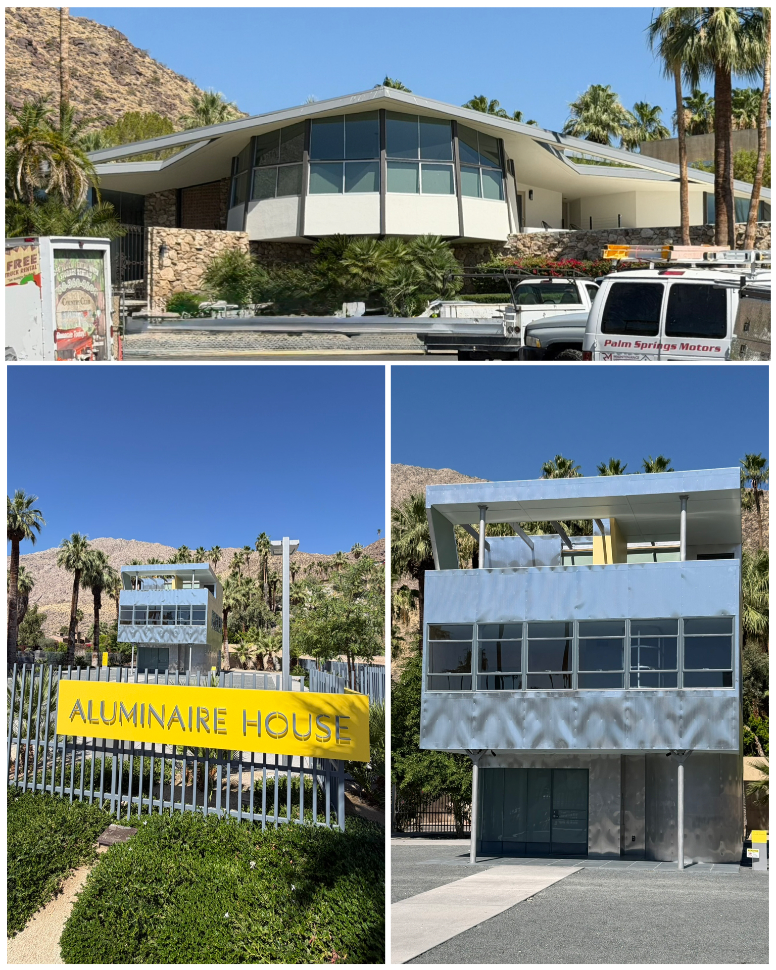
Another house that I visited was this Aluminaire House (at right, bottom). Originally built in 1931 over a 10-day period as a case study by several architects, it was the first all-metal house in the country. This three story, five room, 1,100 sq foot house spent the next couple of years traveling throughout NY as an architectural exhibit. A few private owners held it for several decades, and when in 1980 it was threatened to be demolished, instead it was donated to the New York Institute of Technology and put on their campus. When that campus closed, it was donated again this time to the Aluminaire House Foundation who disassembled it and placed it in storage. Then in 2018, it was shipped to Palm Springs to be part of the Palm Springs Art Museum. Several years of restoration fund raising ensued, and finally in March of 2024, a grand opening at its current location was held. I would have liked to have seen the inside though.
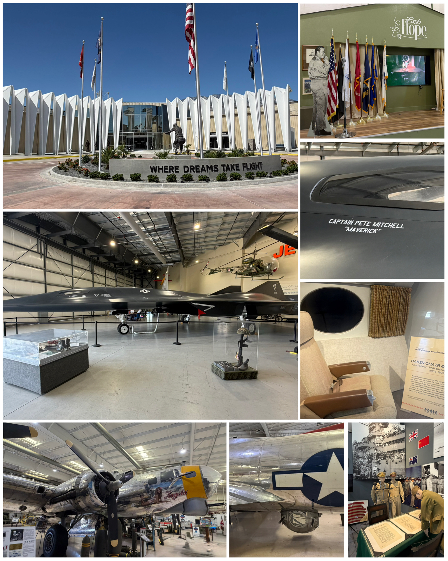 My last stop in Palm Springs was a visit to the Palm Springs Air Museum. Having been in the Air Force for just over 10 years, I hold a special place for military aircraft. It was a nicely done museum with its 89,000 sq feet of indoor hanger space, protecting upwards of 70 vintage planes. The hangers were seperated by conflict – one dedicated to the Pacific Theater of World War II, while another features planes from the Korean and Vietnam era. A couple of the notable display items included the beautifully restore Miss Angela – a WW II era B-17 Flying Fortress (at left, bottom left and center), and the made from wood fictional SR-72 Dark Star (at left, left center and right mid) that was used as a prop in the filming of Top Gun: Maverick. There were also a number of nicely done dioramas that depicted various things or events such as a Bob Hope USO special, or the surrender signing that took place on the deck of USS Missouri in Tokyo Bay. Though not military in nature, they even had a display of a chair and window from the private Gulfstream owned and used by Walt Disney. Overall it was a very nicely done museum that featured lots of really cool historic military planes, with plenty of docents, many of whom are veterans, at the ready to share their knowledge. Though I didn’t get the chance to visit it, they also have a 2nd floor extensive library which also includes several computer-based flight simulators. Nicely done Palm Springs!
San Dimas, CA
And now, I’ve arrived at my first of 16 one-week stops where I’ll begin my exploration of Rt 66. Staying anywhere near downtown Santa Monica or even Los Angeles for that matter, is not something I’m interested in. Rather, I prefer to stay further out in more of a country setting, and just take day trips driving in to town to explore. That way, I get to get out of the hustle and bustle of the big city, and back to the quiet peaceful setting to relax, rest and recharge. Bonelli Bluffs is a beautiful campground in San Dimas – 45 miles east of LA at the base of the San Gabriel Mountains, on the shores of Puddingstone Reservoir. A perfect place from which to launch a tour of the most westerly section of Rt 66. But this initial venture was not without its issues.
 A couple days before arriving here, I got a check engine light on the truck. Great – now what! I used my code reader to determine the alert pointed to an exhaust gas temperature sensor. Well, that at least doesn’t sound too serious. I cleared the code just to make sure it was not a fluke, and sure enough, it quickly came back. So, I made an appointment with the local Ford dealership for Wed morning – the morning after my arrival. So I dropped off the truck, and they provided a courtesy ride back to the campground. I figured it would be a day or two to get fixed, so I could catch up on other chores (like writing this blog) with the downtime. Well, a day turned into two, then three, and by Friday afternoon with no vehicle, I was getting concerned that I would not get to see anything while I was here. The bad sensor did need to be replaced, but apparently excessive rust in the underbody of the truck was making it difficult to extract. They finally threw up their hands, and ordered a total replacement holder for the sensor, but that would reportedly not arrive until Monday. Since it was taking so long for the repair, I asked for a loaner vehicle which they were kind enough to provide. I picked it up late Friday afternoon, and used it on Saturday and Sunday to play tourist. In the end, I was just shy of $700 poorer getting my truck back at 5:10 pm on Monday, with an 11 am scheduled departure on Tuesday. Nothing like cutting it close! Hopefully this will be the end of trouble for this trip.
Route 66
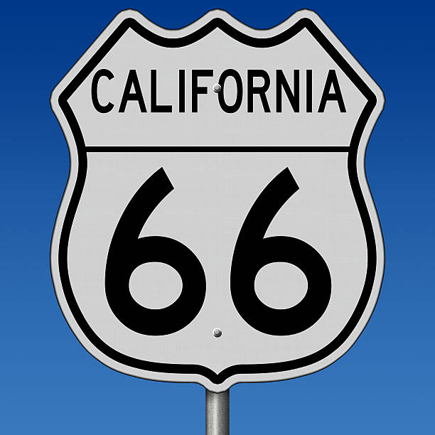
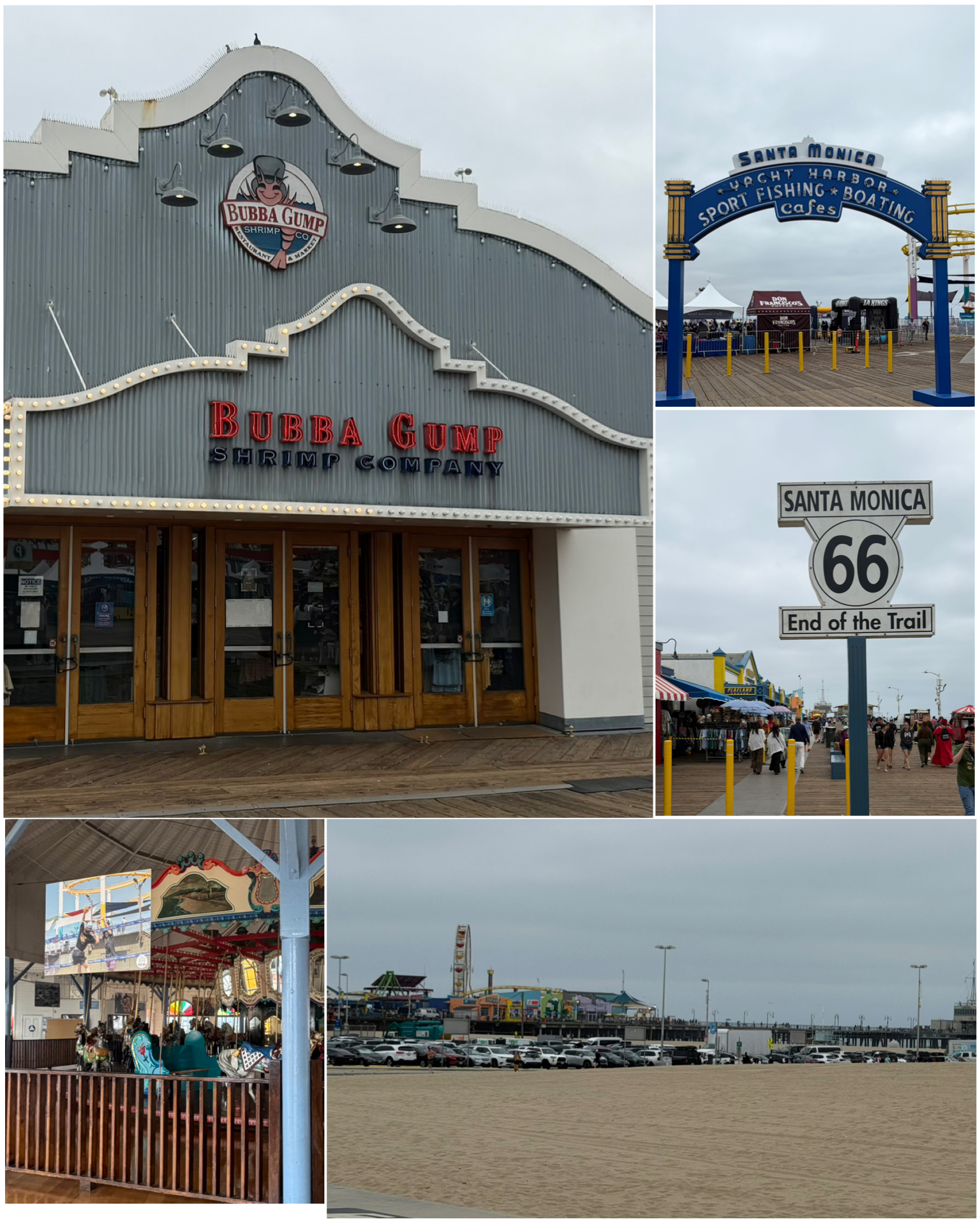 This is where it all starts – the pier at Santa Monica – one of the end points of Rt 66. There’s the obligatory “End of the Trail” sign that makes for a necessary photo op, so that was my first planned destination. Given it was a weekend, I was a bit concerned about parking in the area, so I got an early start to get there. Parking was in fact a challenge as there was some sort of major event going on there for the weekend. But, I finally got a spot in the lot, and headed over to the pier to check out the sites. After getting the mandatory end of trail selfie, I wandered around a bit to see a few other things of interest. Of course, this would include the Bubba Gump Shrimp Co. restaurant, complete with an atmosphere reminiscent of the hit Forrest Gump movie. I also got a picture of the Santa Monica Yacht Harbor sign leading into the pier. Also at the pier in the Hippodrome is the world famous Santa Monica Carousel. This historic ride, consisting of 44 horses, 1 rabbit, 2 sleighs, and 1 goat, was built in the 1920s and has been here at the pier since 1947. I was there at the pier so early that the ride had not even opened yet. So, the best I could do was taking pictures through the glass. Not ideal, but was my only option. So much for getting up early!
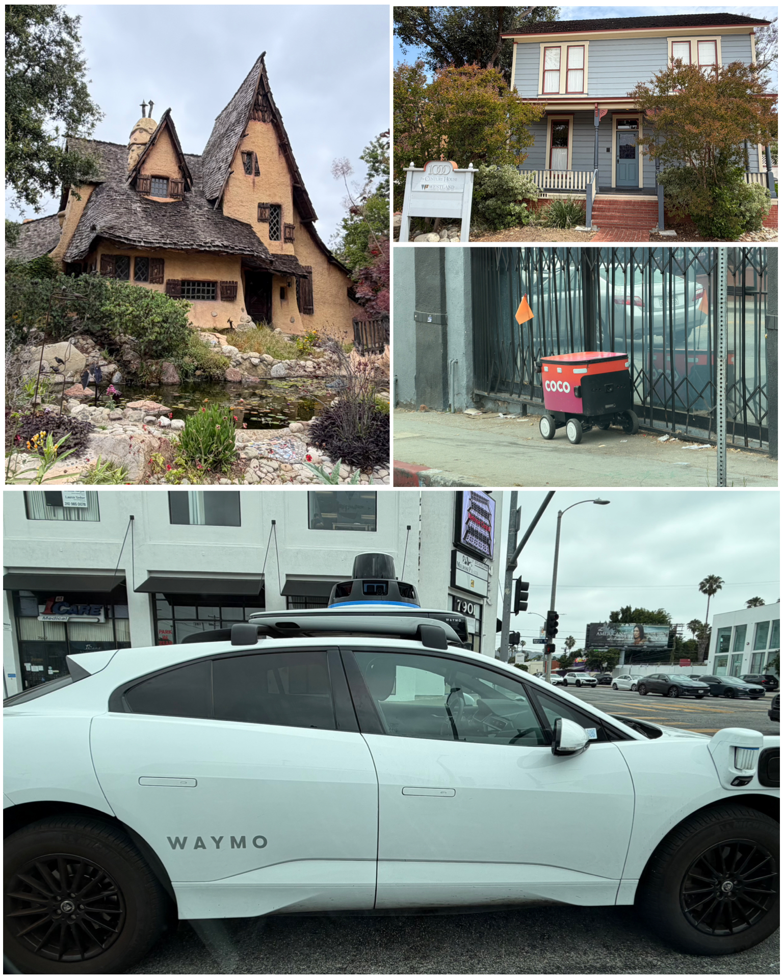 I took a few more pics in the area, including a distant shot of Muscle Beach. But the crowds and overall craziness convinced me to move on in my adventure. So off I went exploring interesting sites along and around the area. First up was a visit to this absolutely cool house known as the Spadena House, or also called the Witch’s House (at right, top left). This fantasy style home, with its intentional crooked roof, was built in 1921 by Hollywood art director Harry Oliver to be offices and dressing rooms for a film studio in Culver City. It was relocated here to Beverly Hills in 1926, and now sits among many McMansions in the neighborhood. Definitely a very cool place! Another house I visited was this place (at right, top right) that was the film location in the original John Carpenter “Halloween” movies, and was featured as Michael Myers’ home. At the time the film was made in 1978, the house was actually abandoned – making it the perfect setting. The other thing I saw regularly while driving through LA and its suburbs, was the proliferation of these Waymo autonomous cabs (at right, bottom), as well as these little self driving delivery boxes (at right, center right). The picture of the Waymo was taken at a red traffic light, and you can clearly see there is nobody driving this thing. As for the delivery cart, it travels down the sidewalks on its own making its way to someones home. Too funny!
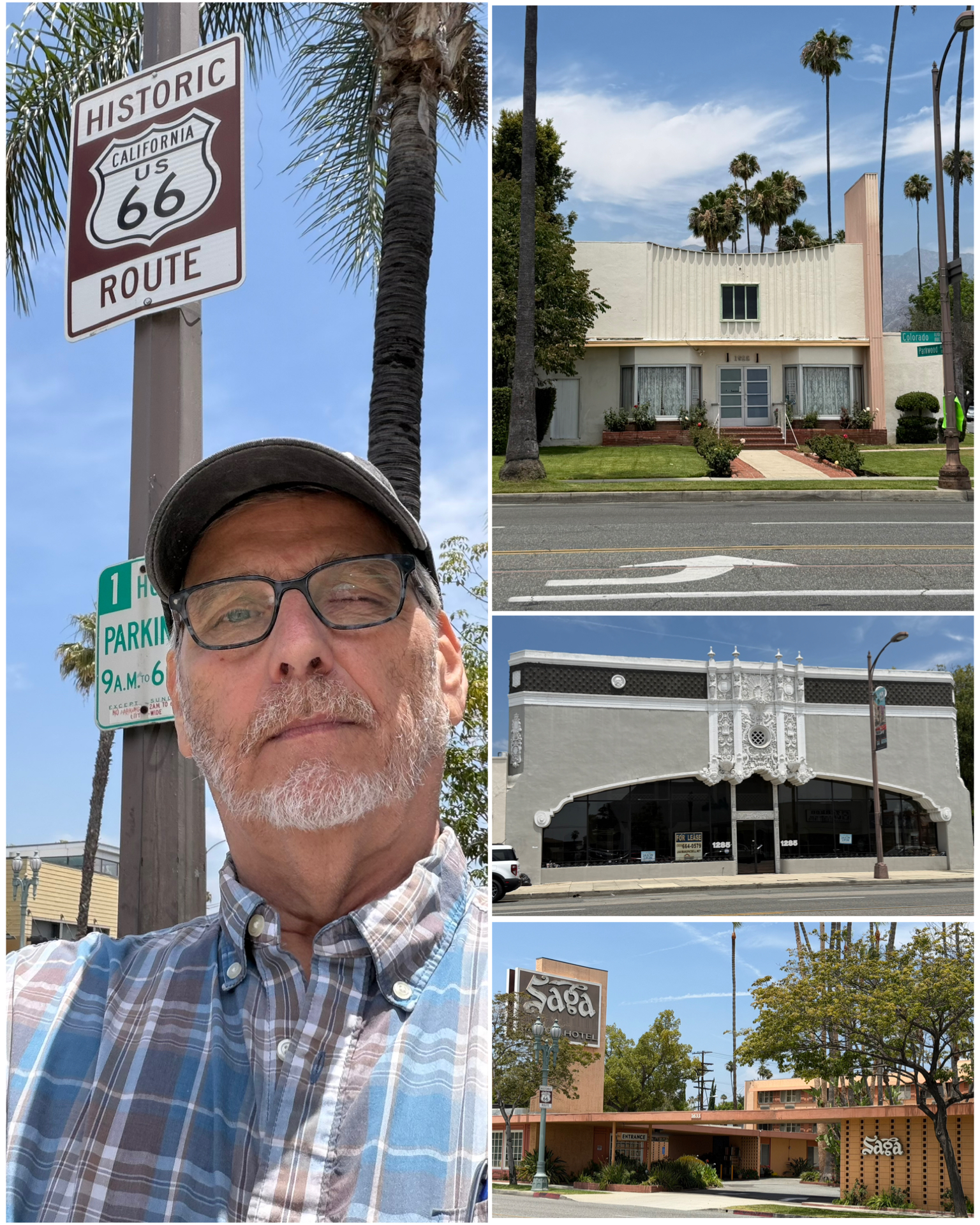 I had a few other Rt 66 attractions in the LA area to visit, but found that it was way too difficult to navigate to and find nearby parking. Such is the challenge when visiting things in the big city. I finally gave up and decided to move outwards a bit to a more favorable driving and parking conditions. This brings me to Colorado Blvd in Pasadena. Several iconic places to see here. First up is the Howard Motor Company building (at left, center right). Built in the mid 1920s, this Buick car dealership was to entice drivers in the early days of Route 66. The buildings central, over the top facade features mythical characters, shells, medallions, and fancy scrollwork, with a full-building arched showroom window to display the prestige branded vehicles of the time. Despite having been vacant for several decades, it has survived unaltered and still standing for over 100 years. Next was the iconic Saga Motor Hotel – not only a Rt 66 icon, but also a place that sits along the route of the famed Rose Bowl Parade. Built in 1959, this hotel was top notch at the time as it featured a telephone, television, and AM/FM radio in each of its air-conditioned rooms. It has also been featured in a number of movies and television shows as a prime filming location. The last historic building featured on this road was once a bright pink structure built in 1948 to be a clothing store named Draper’s Studio of Modes”. Draper died in 1983, and the building has since been converted to a dentist’s office. Despite the bright pink colors having been subdued, the building remains on this list of historical landmarks.
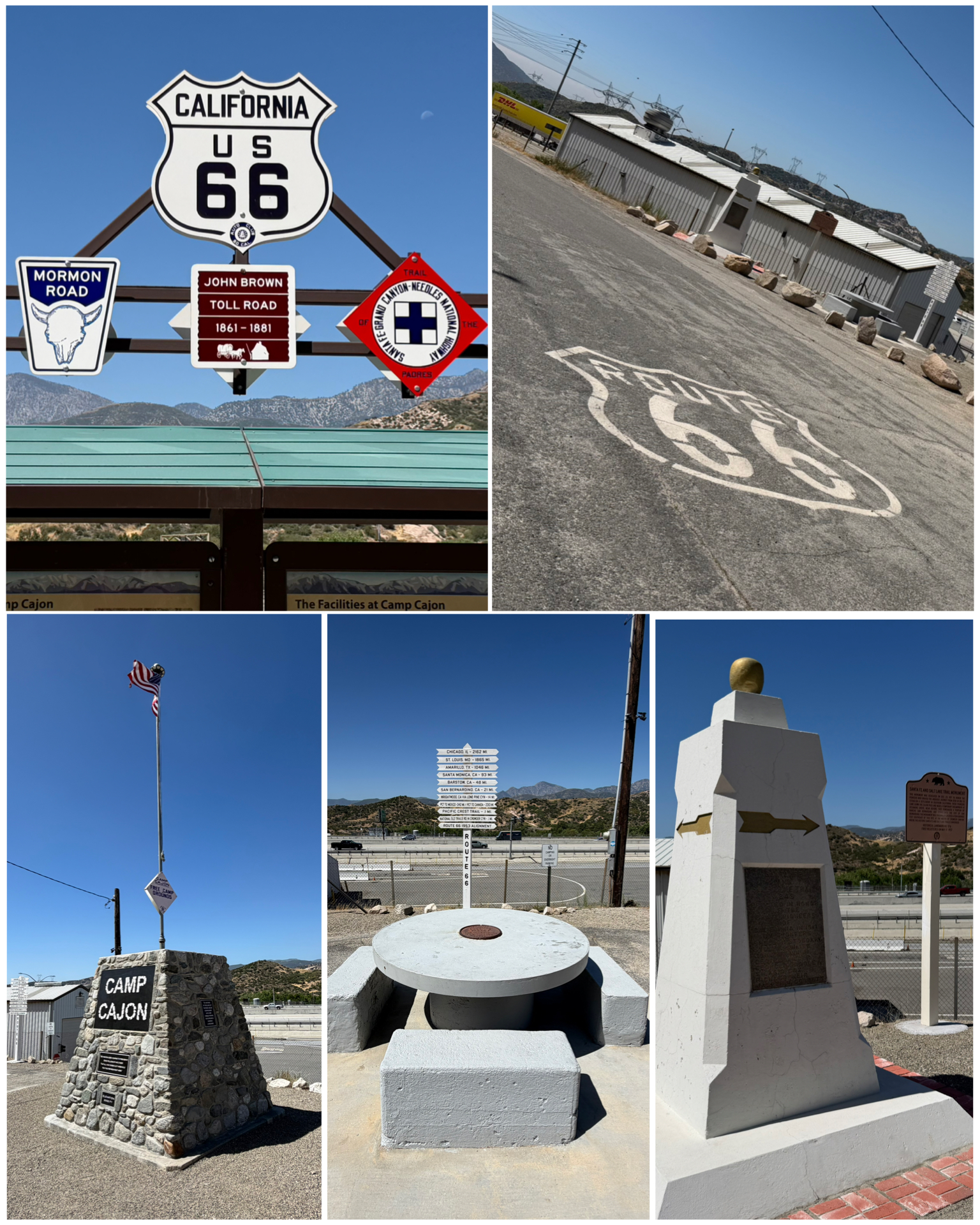 The next day, I headed east to the farthest stop from this, my first week-long stay, then worked my way back to the west checking off several attractions along the way. My first stop takes me to Phelan, CA and several oddities on an old section of Rt 66. Before Rt 66 came about, other trails were used by pioneers to traverse the country. Two such trails, the Santa Fe and Salt Lake, crossed as this point in Phelan. A monument (at right, bottom right) dedicated to the trail intersection was created in 1917. A couple of folks who attended the monuments dedication were so inspired that they crated a place called Camp Cajon at this location – which later would fall along Route 66. The camp was an early rest area that became well known for its flag-topped monument and round concrete picnic tables. The camp was mostly destroyed in the great flood of 1938 and mostly forgotten for decades thereafter. In 2019, the 100th anniversary of the camp’s opening, a group of Route 66 preservationists recreated the iconic monument (at right, bottom left), and managed to resurrect one of the picnic tables that had apparently survived the flood. I’ll bet this was quite the place to visit back in the day.
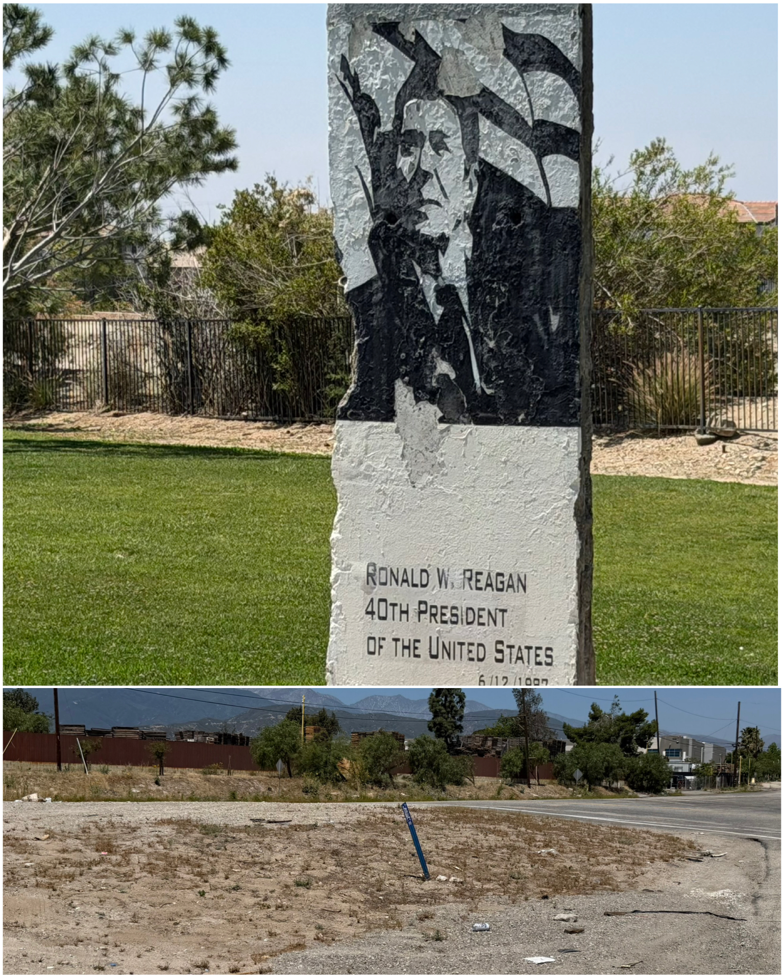 Next I followed the Cajon Blvd section of Rt 66 to the town of San Bernardino. Now for this first Rt 66 roadside item, you will have to use a bit of your imagination. It was on November 19, 1954 at the intersection of Cajon Blvd and Kendall Dr (at left, bottom) where music legend and Rat-Packer Sammy Davis Jr. would crash his new lime green Cadillac. He was driving an all nighter from Las Vegas to LA for a recording gig when at 7am he crashed and his face went into the metal steering wheel, causing the loss of his left eye. Supposedly there was a plaque at the site that was just placed there in 2026, but for the life of me, I could not find it. So the best I could do was to simply take a picture of the intersection. A mile further down and just off the main drag was this Reagan monument sitting in a large grassy area known as Reagan Park. This 12 ft high chunk of concrete is a slab from the Berlin Wall. At the time of receipt in February 2011, there were grand plans to create an educational park with a statue of the president, and a walkway section featuring several of his famous quotes. But, none of that materialized and instead they painted the wall section with his portrait and left it at that. Still, a really nice piece of history.
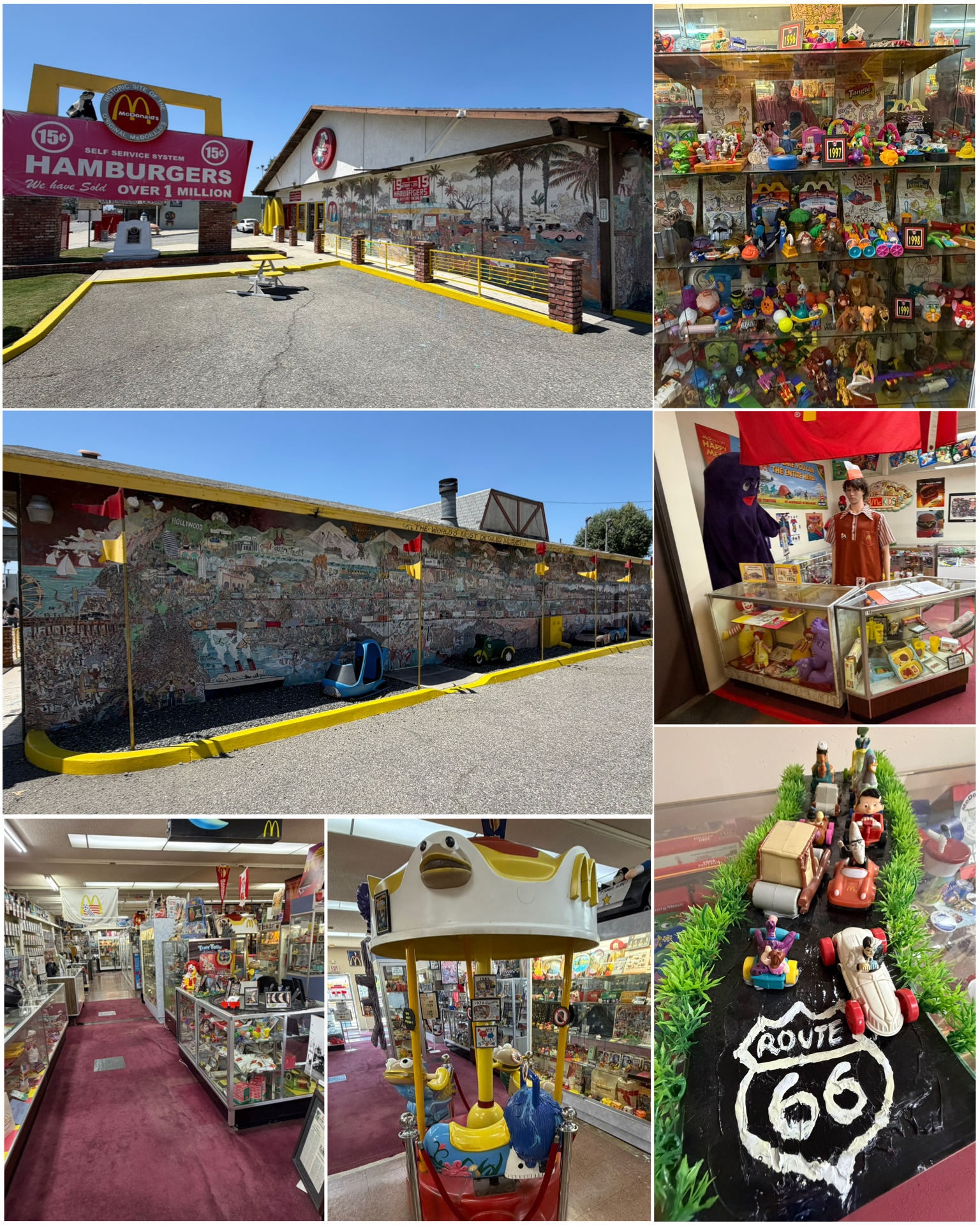 I continued my trek into downtown San Bernardino to check out the location of the very first ever McDonald’s, and what is now a prominent McDonald’s museum. It was brothers Richard and Maurice McDonald who first opened McDonald’s Famous Barbecue at this location in 1940. Besides BBQ, the car-hop drive-in also sold chilli, tamales, and even PBJs. In 1948, they ditched those plans and menu in favor of a burger slinging joint. In 1953, the original building was bulldozed and up came the first iconic Golden Arches McDonald’s restaurant. In 1972, that building was then bulldozed, and a generic non-McDonald’s building went up in its place, and remains today. It was here in 1954 that Ray Kroc, a traveling milkshake machine salesman, tried to sell the McDonald brothers a MixMaster. Instead, Kroc ended up buying their name and business instead. The rest is history! Food chain Juan Pollo rotisserie chicken owner Albert Okura purchased the building in 1998 and soon thereafter opened the McDonald’s museum. Interestingly, every piece in the museum was donated by the public – many of them featured with pictures and dates of donations along with the actual display piece. No support has come from McDonald’s corporate – who reportedly have little regard for past history, and prefer otherwise to look ahead and evolve to continue their burger dominance. Among the thousands of the more prominent artifacts include pieces of salvaged PlayPlace equipment, original grill scrapers and uniforms, souvenir glasses and Happy Meal toys from pretty much every year and decade. It was quite the place, and truly represents the love of the brand by its many dedicated fans.
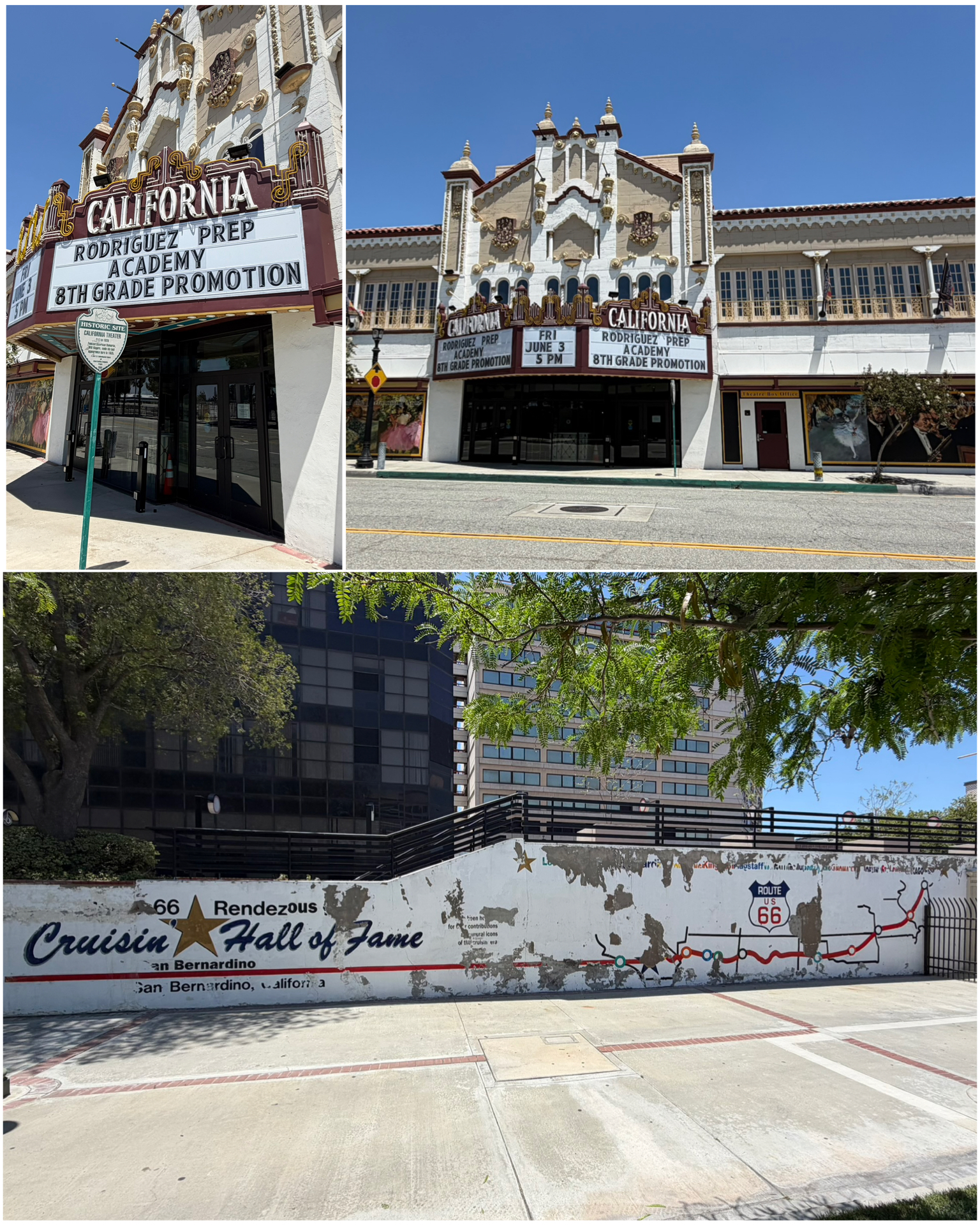 A further venture into downtown takes me to these Rt 66 gems. First up, the absolutely beautiful California Theatre of the Performing Arts building (at left, top). Built in 1928, it started life as a vaudeville house and would also show movies. It was here on June 28, 1935 that Will Rogers gave his last performance before being killed in a plane crash three weeks later. It was this tragic accident along with Will’s Oklahoma hometown and affiliation with Hollywood as an actor – both locations along Route 66, that encouraged proponents of the Mother Road to also give Rt 66 the alternate name of Will Rogers Highway. Next, just around the corner is the remnants of the Route 66 Rendezvous. This was a big annual event for San Bernardino cruisers, and got so big, they got their own Plaza to host the event. Along a long wall within the plaza, a map of Rt 66 was painted (at left, bottom). Each year, a bronze plaque was added to the map to recognize icons of the cruising era. Past awardees included the film American Graffiti, and In-N-Out Burger. Sadly, the Rendezvous lost its funding in 2013, the hall of fame closed, and the plaques were removed. But, the map remains – in desperate need of some touchup however.
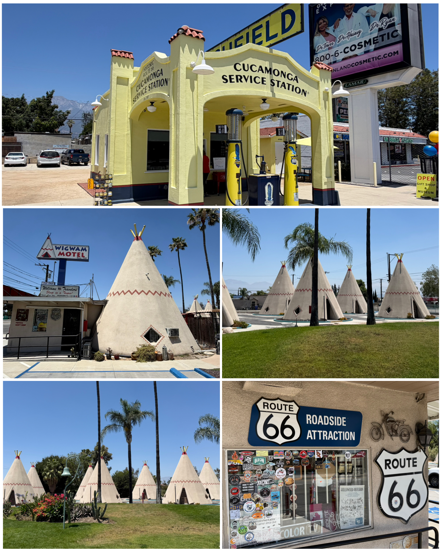 I next get back onto Rt 66, on the Foothill Blvd section in San Barnardino. There, I would come to my next exciting stop – the Wigwam Motel, or as it is also known as Wigwam Village. This is one of only three remaining wigwam-themed hotels from a once chain of seven locations across the country. The other two remaining locations are in AZ and KY – with the AZ and CA locations right on Rt 66. As an aside, I have a one night reservation in July for the AZ location for my brother and I while we are visiting the area. When in town, might as well sleep in one of these things! Built in the 1930s and 1940s, the teepee shaped structure is constructed of concrete, and contain basic accommodations to include a bed and restroom. 20 structures make up the San Bernardino village, and according to the proprietor that I had an opportunity to chat with, are pretty much fully booked throughout the summer and fall months. Most likely benefitting from this year’s centennial celebration. Next, I visited one of the few original buildings still standing on California’s Route 66 in Ranch Cucamonga. The Cucamonga Service Station was built in 1915, and served the public’s gas needs up through 1970. In 2011, it received its historic landmark designation, after which it was donated to a group of local citizens focused on preservation. They’ve done a great job with the restoration as the place looks great!
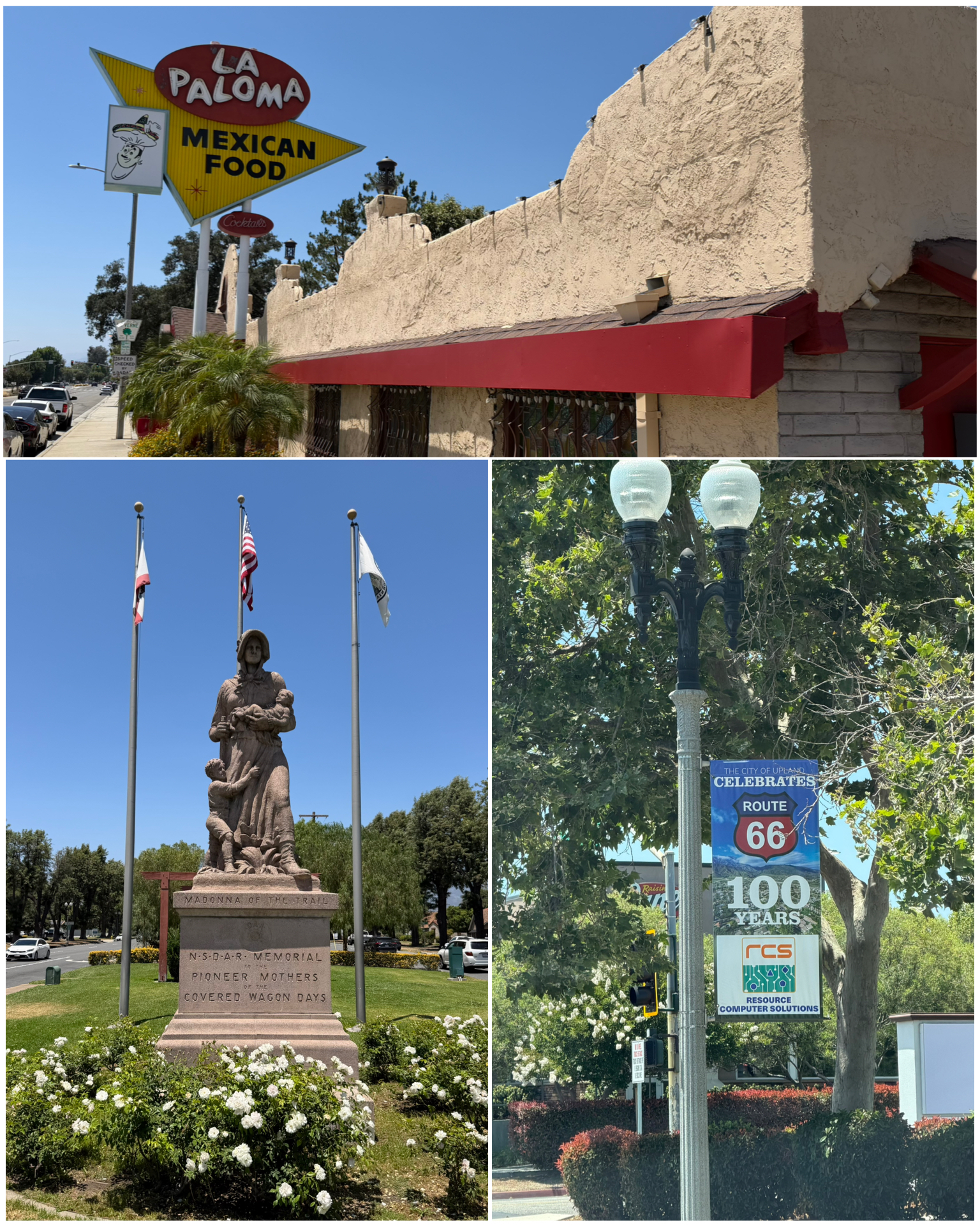 My final couple of stops takes me further west on Foothill Blvd, first in Upland, CA. Here we find this town’s Madonna of the Trail monument sitting nicely in a grassy park area within the center section of the intersection of Rt 66 and Rt 83. This Madonna monument is one of twelve such statues that exist from Maryland to California – tracing the historic travel route from the old covered wagon days. This was a project of the Daughters of the American Revolution who installed these monuments across the country in the 1928-29 timeframe. Interestingly, this particular monument was destined for nearby San Bernardino, but the city disliked the proposed location, and was also unwilling to pay the $1,500 to create the statue base. So the nearby town of Upland jumped in and convinced the DAR to put it in their town. Nice win for Upland! Driving down many of the California Rt 66 roads, there were these 100 year celebratory lamppost signs hung up and down the route. A nice touch to add a bit of atmosphere to the area. My very last stop on this leg of Rt 66 exploration, and my late lunch venue, was this place in La Verne, CA. The building actually began life in the 1920s as a fruit stand that sat next to a citrus grove. They offered all-you-can-drink orange juice for $1 to weary Rt 66 travelers. Business was so good that they expanded the business to include a sandwich shop, followed later by a steak house. By the early 1960, both founders had since passed, and the building abandoned. A new entrepreneur purchased the place in 1966 and reopened it as La Paloma. The Mexican restaurant remains today, and is reportedly run by the grandkids. I can attest that the food and atmosphere are top notch!
Final Thoughts
Well, it took me the better part of a month to travel from Florida to California. That may sound like a slow pace, and I guess to some degree it was. However, the short 2-night stays get old after a bit. It was really nice arriving at my first week long campground and catching my breath. I’ve got 15 additional week long stops ahead of me as I follow the Mother Road al the way to Chicago. There’s no doubt plenty to explore and blog about as the journey proceeds. So, buckle up and get ready for lots of interesting content in the coming months. Till next time, safe travels.
I only show a sampling of my adventure pictures here in the blog, and do so mostly in collage format for brevity and ease of reading. If you want to view an album containing individual full fidelity and hi-res images of all my travel pictures related to this specific blog, click the image below. Enjoy!
Car troubles already yikes! Hope thats the end of them. Quite the interesting blog. You went to some interesting places. Must be hard with the truck to find good parking spots. Maybe you should have used a Waymo to get around. LOL Lot of good signage promoting the100th anniversary. Hope you enjoy your night in the Wigwam. Well have a safe trip.along Route 66 and looking forward to.more pictures to enjoy.
Yea, truck troubles suck! But, it is a 14 year old truck, so sadly things are gonna break. Just hope they stay to a minimum. And driving and parking that thing in a large metro city is not for the faint of heart. In retrospect, Waymo certainly might have been a better choice!
The sweet pie musician is quite the character; guess sometimes you need something to get seen (literally). Sorry about the truck issue, you were lucky it happened when you were somewhere with a dealership, hopefully that will be all for this trip. I agree with David about using Waymo in the big city to get around. Looking forward to all the Rt66 posts.
Paul Winer was most certainly a character. I would have loved to chat with him back in 2014, but he was just to famous and surrounded by people. And yes, the truck issue happening while I was near a dealership was most beneficial. Could have been worse.
It has been 12 years since I drove rt 66 so your blog will bring back memories. This one certainly has! I especially remember the service station in Cucamonga. I will soon be out there with you and looking forward to seeing the road again.
I suspect as I continue to journal my trip, you will likely find that little has changed on the Mother Road since your visit back in 2014. We can only hope that there will be things still around for the next few generations to explore and enjoy. See ya in a few weeks!
Great start to the adventure! Hopefully, getting away from the big cities will be more relaxing, but the whole trip might be sort of crowded, especially around July 4th. Hope you have no more truck issues to slow you down. I look forward to reading all about it – you may have to blog every 2 weeks to get it all covered. 🙂
Have fun and safe travels!
Hi MG! Yes, blogging more than once a month will definitely be in order. There’s just way to much to see, explore, and write about. I’ve already begun my second Jun edition which will no doubt be released in the next week or so. I’m having a great time so far, and look forward to all the amazing things there are to see on this route of travel. No doubt the route will be busier this year with the centennial, but that’s ok as it makes the trip all that much more enjoyable. Hope all is well with you!