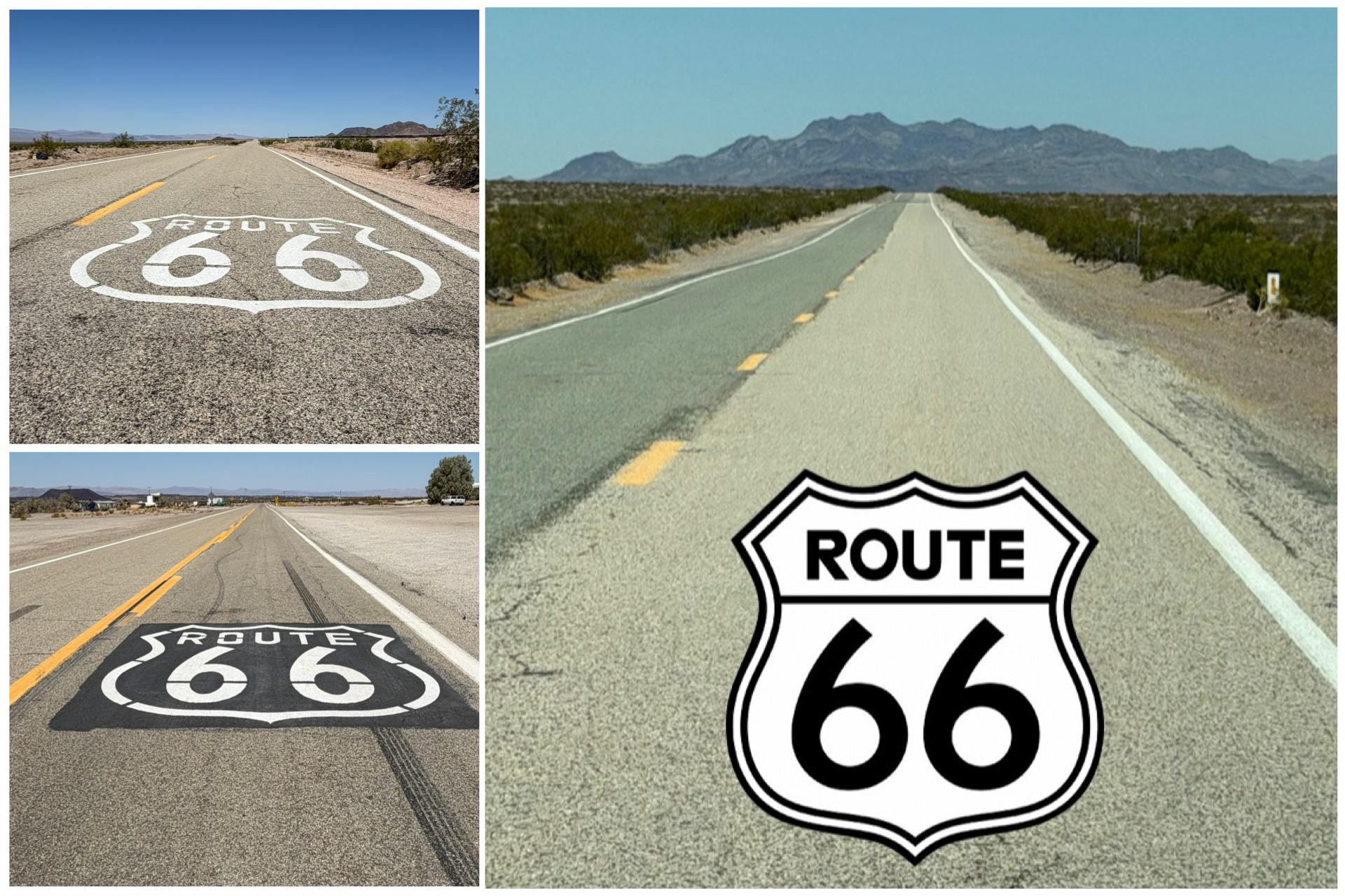
Despite the Mother Road no longer officially recognized, that which remains sure is scenic! Many of the local communities have done a great job of painting the Route 66 logo all throughout the road. Well, at least most of the place. The picture of the Rt 66 road at right above was so perfectly photogenic, I had to pull over, stop, and take a picture. That area would have been an ideal spot to have the logo painted on the roadway. But, since it didn’t, I added one myself. The adventure continues along this roughly 150 mile leg as I explore this portion of California route including Barstow, Daggett, Amboy, Ludlow, and others – all the details of which follow.
Yermo, CA
Well, I’ve returned to the Mojave Desert region of southwest California, and its daily triple digit temperatures. Damn it’s hot here! But at least there isn’t any traffic! My next weekly stopover along the Rt 66 trail takes me to Yermo – home to its 623 residents. Like many back road communities, Yermo took a hit when Interstate 15 openned in 1968 and traffic to and from LA bypassed the town. As a result, 90 percent of business ceased. Fast food chain Del Taco was founded here in 1964, and even that restaurant with its historical pedigree did not survive and was eventually bulldozed. The biggest economic venture here in town is the almost 2,000 acre Marine Corps Logistics storage facility. Otherwise, not too much.
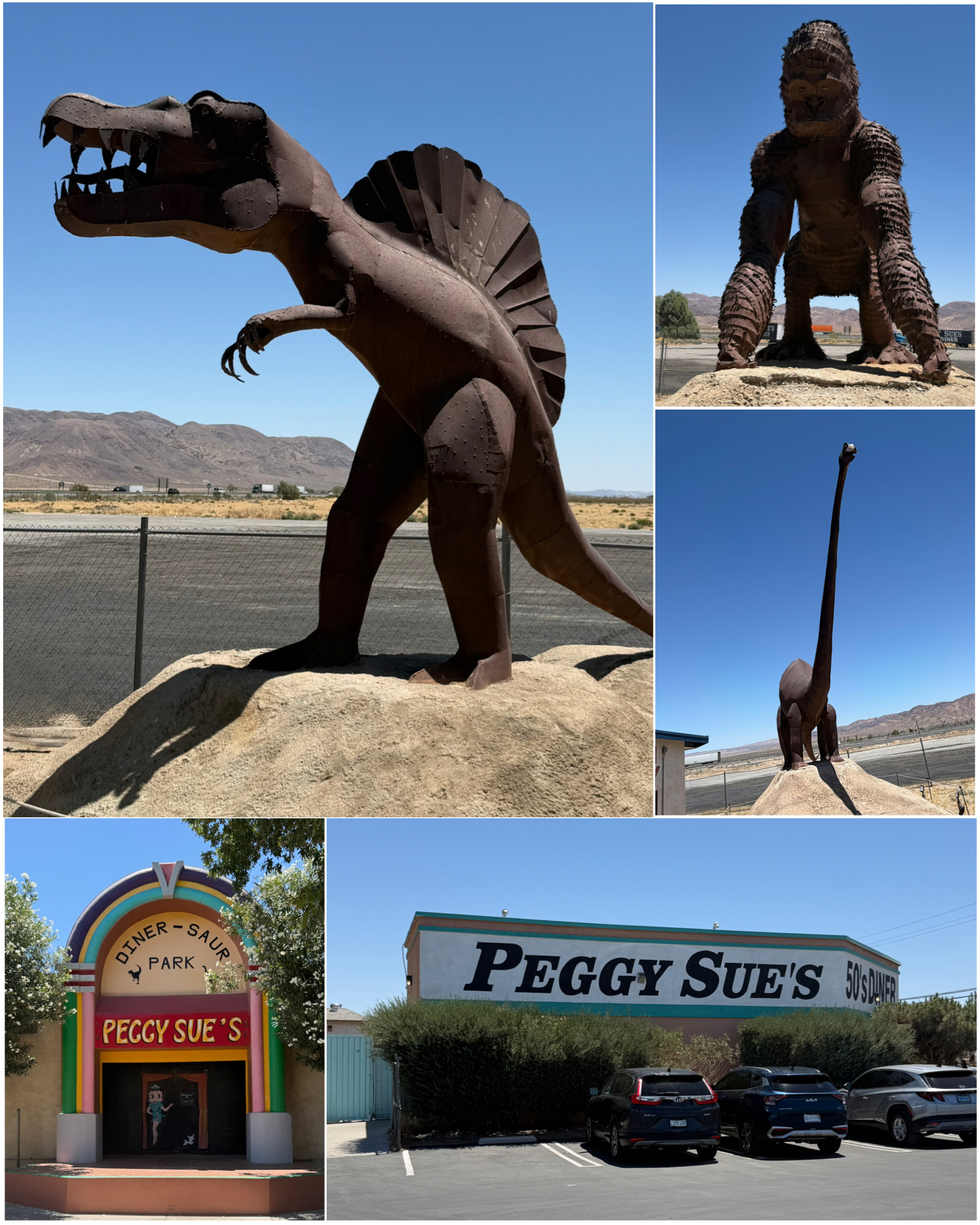 There were however a couple of interesting places to visit here in town. Peggy Sue’s 50’s Diner and its accompanying Diner-Saur Park were particularly noteworthy. This 1954 built middle of the desert roadside diner features menu items named after celebrities such as James Dean Fries, or burgers named after John Wayne, Fats Domino, and of course, Buddy Holly – who notably put the name Peggy Sue on the charts. Besides the food, there is also an extensive memorabilia collection belonging to the owner. Then, in the back of the place, is the Diner-Saur garden that features several giant metal dinosaurs, and other creatures. There’s lots of seating for an outside lunch, along with a small stage area presumably for various shows. But,
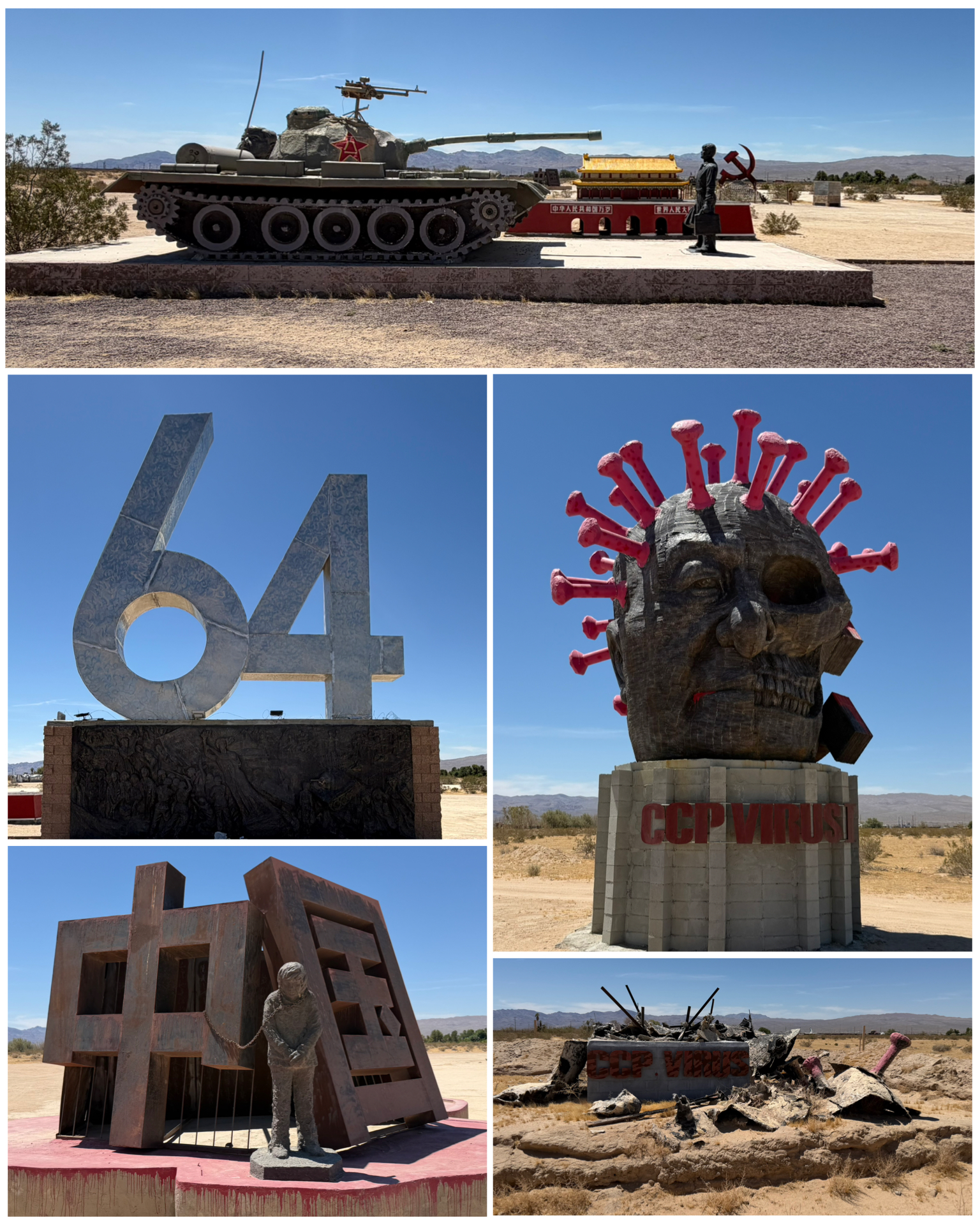 apparently neither the outdoor tables or the stage get much use in the 110 degree summer heat. It was a cool and interesting place to visit.
Also in Yermo was this really strange place. Known as the Liberty Sculpture Park, this 36 acres of desert land along Interstate 15 was purchased by Weiming Chen – a Chinese-born dissident and artist. Its theme was to b the champion of freedom and to condemn the oppression of Chinese communism. In 2019 Chen produced a couple of pieces dedicated to recognizing the atrocities of Tiananmen Square. One features the numbers 6 and 4 – the date of June 4 when the massacre occurred. Besides simply the number 64, lots of other references to the event include that fact that the numbers are 6.4 meters tall, the numbers are angled at 64 degrees to each other, and that the piece is said to be 6,400 miles from the massacre site. The other Tiananmen piece titled Tank Man (at right, top) depicts the famous photo of a businessman with a briefcase defiantly standing in front of a tank. In 2021, Chen released a sculpture titled the CCP Virus which depicted dictator Xi with bloody face and Covid spikes coming out of his head. Shortly after its unveiling, it was reportedly torched and burned to the ground (at right, bottom right) by Communist China Party arsonists. A new one was built and unveiled in 2022 (at right, center right). In all, there were over a dozen works in the garden, with Chen producing like 1 or 2 each year. Despite it not really being Rt 66 related, it certainly was quite the interesting place!
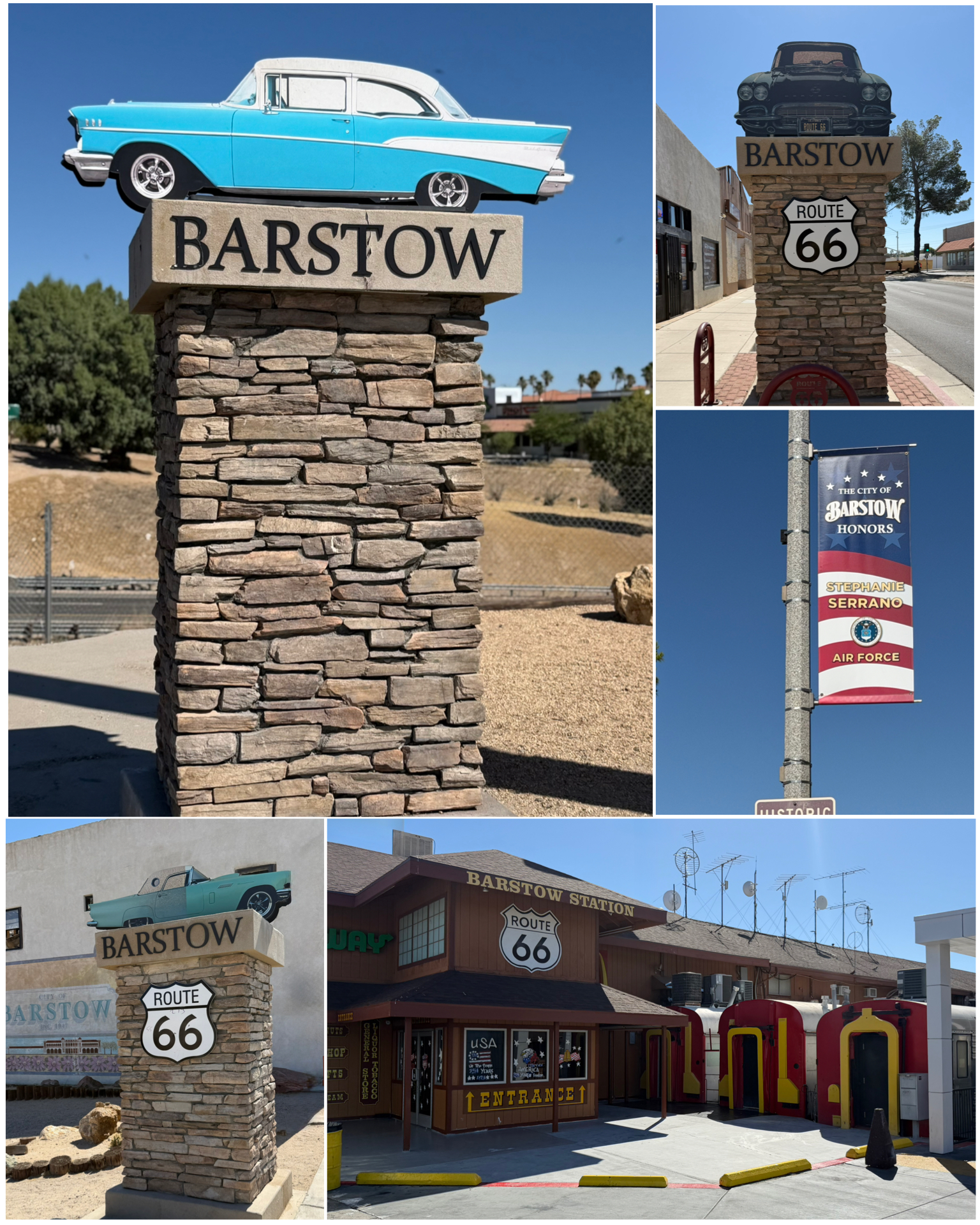 About 10 miles to the west is the town of Barstow, CA, filled with Rt 66 treasures along its Main Street. Throughout town were several of these stone columns and pillars topped with classic cars representative of Rt 66 days. With its population exceeding 25,000, Barstow is known as the “Crossroads of Opportunity” having a busy adjacent railway service, and nearby major roadways of Interstate 40 and 25, state highways 247 and 58, and of course the Mother road itself. It is also home to Marine Corps Logistics Base Barstow.
In 1975 Barstow Station was built to resemble a railway station. This place reportedly serves upwards of 20,000 tour buses a year. It includes a number of gift and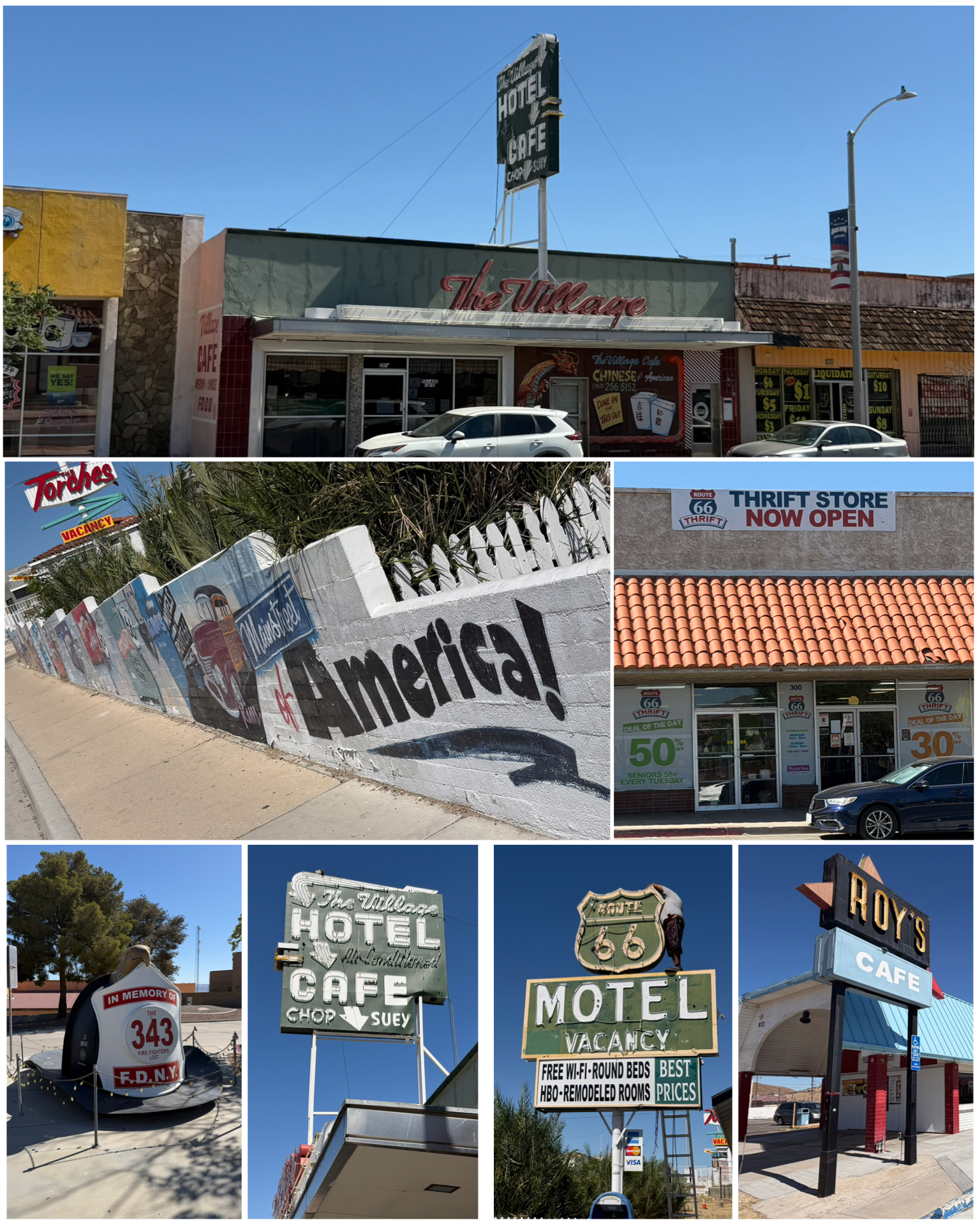 fast food shops including this McDonald’s that features three side-by-side railroad cars for a dining area (at left, bottom right). Pretty cool!
Lots of murals depicting town history and Rt 66 adorn many buildings around town. Lots of historic Rt 66 places along Main St including the Rt 66 Motel, the Village Hotel and Cafe, Roy’s Cafe, and the Rt 66 Thrift Store. The Rt 66 Motel was built in 1922 – just a few years before Rt 66’s official designation. Not shown here but in the full photo release below, the hotel features several vintage cars and lots of Rt 66 memorabilia throughout the property that brings you right in the thick of it from back in the day. Not to be outdone, just off the main drag was this Roadside attraction of a giant FDNY fire helmet. Commissioned by the Barstow fire department, this memorial was created to pay tribute to their comrades who died on Sept 11, 2001. The shield at the front of the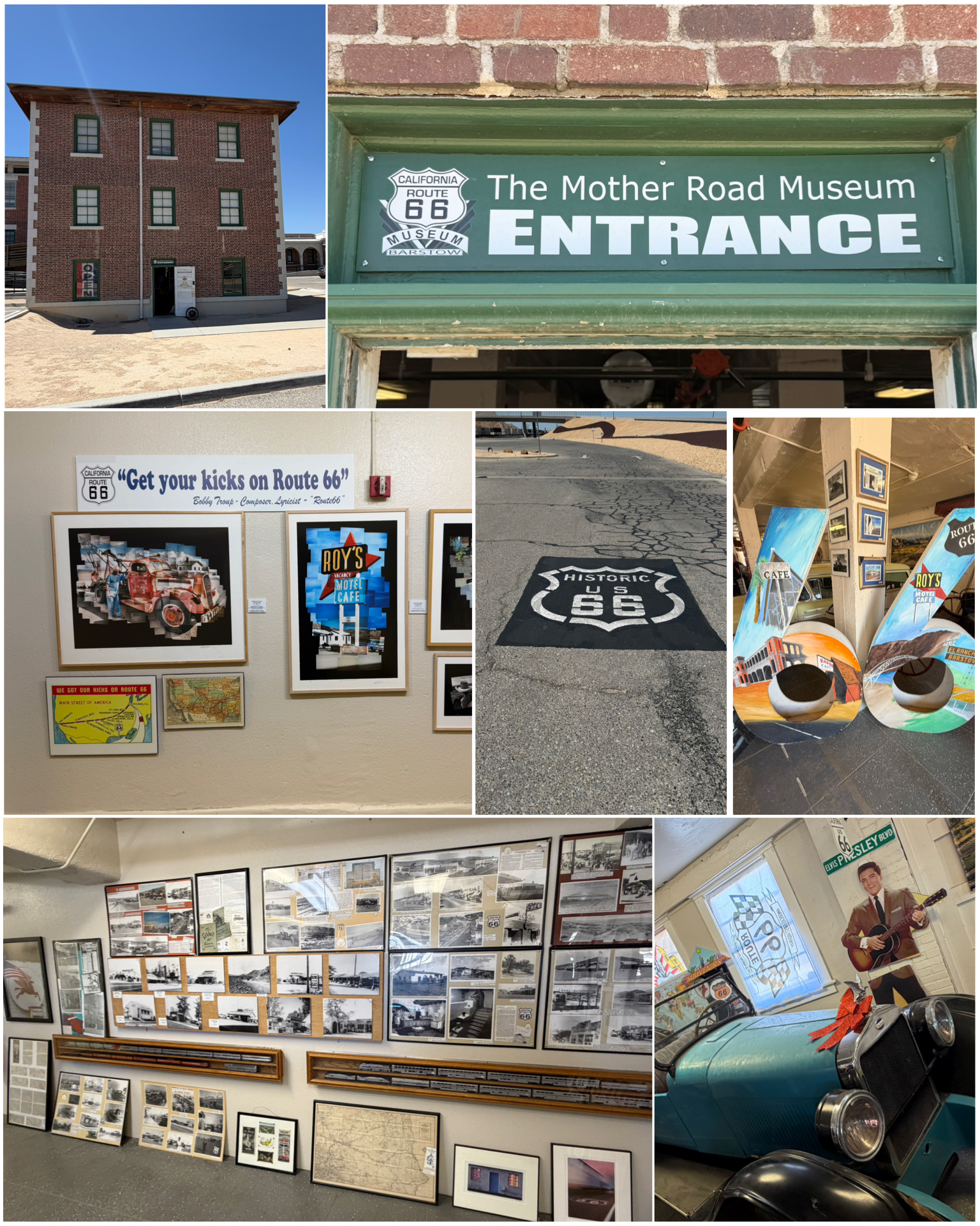 helmet bears the number 343 – representing the number of New York firefighters lost in the collapse of the World Trade Center towers. Very nicely done!
Barstow also hosts the Route 66 Mother Road Museum – a sister museum to the Victorville Route 66 Museum that will be reviewed later in this blog. A quaint little place that shares a larger campus with a nearby railroad museum. Several antique classic cars, collections of antique household items such as kitchen appliances, radios and televisions, and laundry devices make up several displays from back in the day. There are also lots and lots of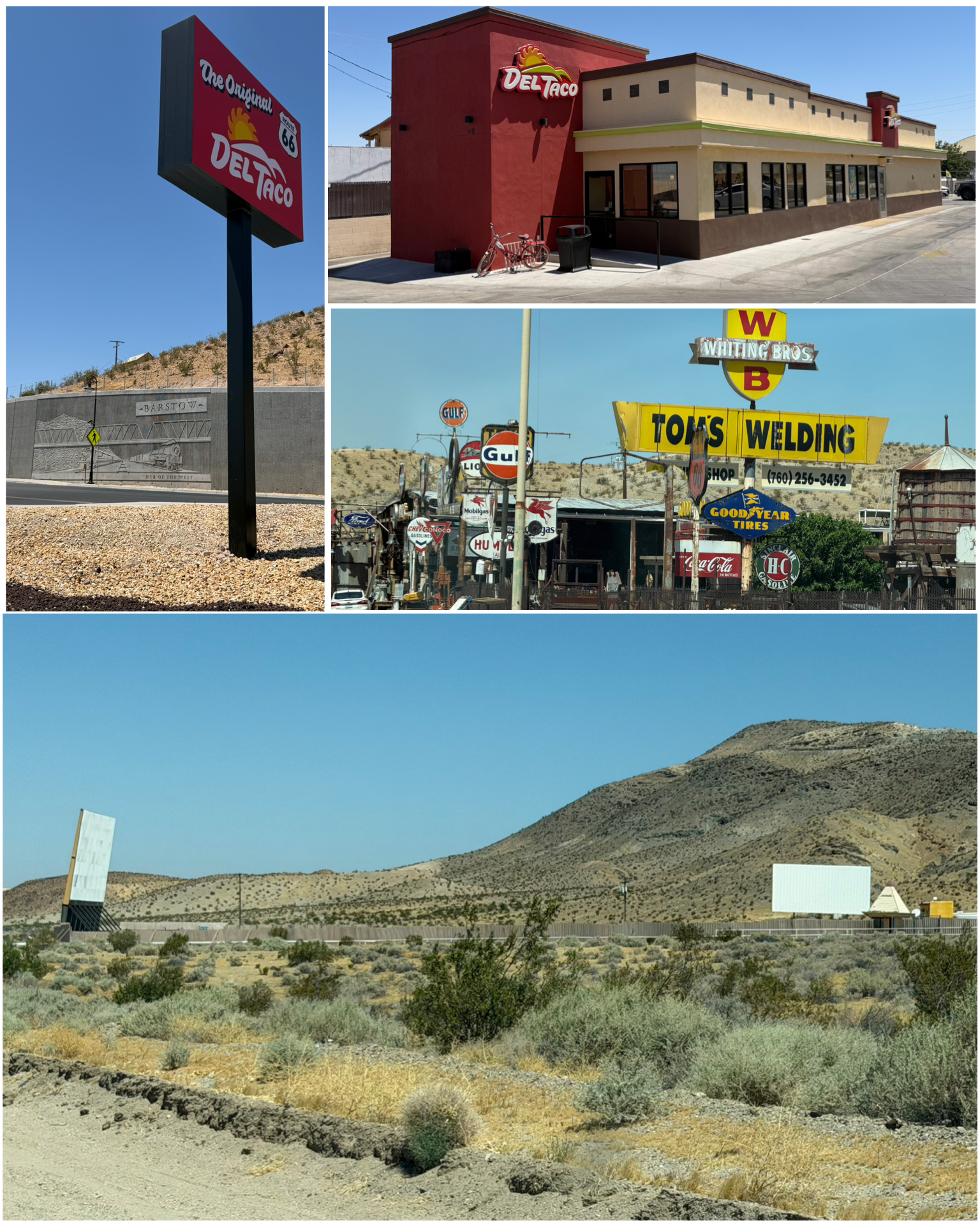 pictures and historical artifacts and memorabilia that tells the story of both the town of Barstow and Rt 66.
Last up in this crazy town were a couple of other interesting sites. First up is the world’s oldest operating Del Taco fast food joint. I have to be honest, I’ve never heard of Del Taco. They have 595 locations in 18 US states – the majority of which are in California and surrounding states. They do have a handful of locations east of the Mississippi. Guess I’ll have to give them a try while I’m in the area. I mentioned above about the first actual Del Taco having opened in Yermo in 1964. It was quite successful, and resulted in a few others being opened – two in nearby Barstow. When the Yermo place closed, the First Ave location became the longest operating place. However, several major building upgrades later (at right, top right) has left the place looking nothing like an original anything. So, the claim to fame is somewhat questionable. Next up is this massive collection of nostalgic gas and other vintage signs that clearly belong right on Rt 66 and not on the outskirts of town. Home to Tom’s Certified Welding Sign Forest, it is the private collection of master welder Tom Lewis. He has decorated the outside of his machine shop and welding business with all these beautiful signs. Nicely done! Last up, though not on any Rt 66 or Roadside America list, I happened to drive past this blast from the past drive-in movie theater along old highway 58. The Skyline Drive-In (at right, bottom) features two screens, and according to their Facebook page, continues to operate to this day. Nice to see these places still exist!
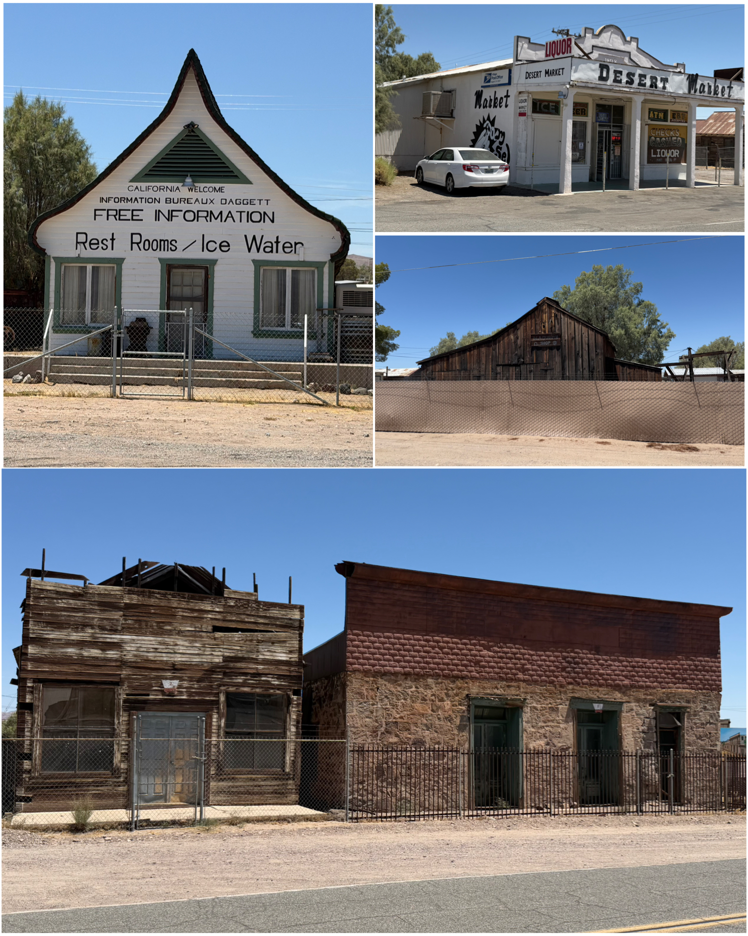 Just south of Yermo where I was staying is the town of Daggett. A small sleepy town with about 200 residents that once was a thriving borax mining town, then later became the location of the world’s first commercial solar power generation facility. Rt 66 runs straight through town and features a number of historic buildings. What once was the Route 66 California Welcome Center (at left, top left) also has the nickname Russian House due to its Russian-like architectural roofline. Besides being a welcome center, the building was also used as a real estate office, a private home, and a cafe. After being empty for many years, it was once again restored in 2025 like a visitor center, but reportedly is actually a private residence once again. Another iconic building, the Desert Market (at left, top right) was built in 1908, and remains a local market to this day. Also in town were the remains of the People’s General Store and the Stone Hotel (at left, bottom) . The hotel was built in 1883 as a two-story building, but after it burned in the 1908 fire, it was rebuilt as a one-story hotel. Both the general store and the hotel serviced many a Rt 66 traveller back in the day. Last up in Daggett is Alf’s Blacksmith Shop (at left, center right) which opened in 1890 by Seymour Alf. Large mule team driven ore wagons were built here which were used to haul borax out of the mines. He also bid and worked on excavation jobs using his wagons to grade many area roads – including what would later become Route 66. The facility has been passed down through the generations who have reportedly preserved it as it was complete with its original forge, all original tools, and even several borax wagons, and today stands as a time capsule of early 20th century blacksmithing. Sadly, it is not open to the public and with its covered fence surrounding the complex, offers little glimpse into that historical time period. This place sure seems prime for a museum!
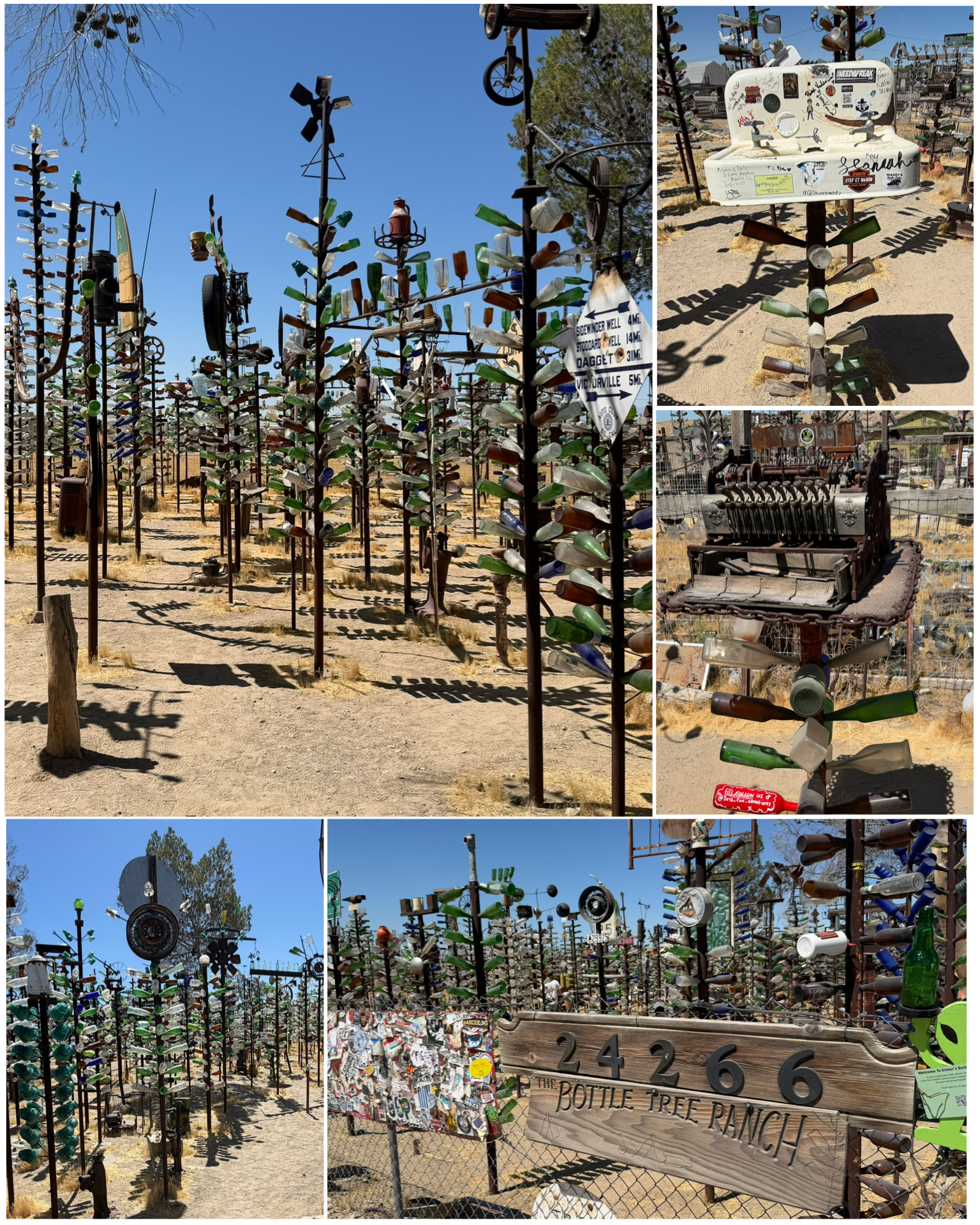 I continued my travels further west heading towards Victorville. Along the way in Oro Grande is this classic Rt 66 gem. Known as Elmer Long’s Bottle Tree Ranch, it is 2 acres filled with metal pipes welded together holding a variety of bottles to create an art jungle. This is the handiwork of Elmer Long – born in 1946. His father was apparently an avid bottle collector, and when he passed, that collection was passed down to Elmer – who continued the tradition by collecting bottles himself. Being a professionally trained welder, he used that skill to build his first bottle tree in 2000. Soon after he noticed various Route 66 travelers stopping in front of his place and taking photos of his bottle tree. Starting in 2002, he devoted his full time to creating additional bottle trees until his passing in 2019 – ultimately creating this amazing ranch. Today it stands as one of the more popular Rt 66 stops along what is otherwise a mostly uneventful stretch of roadway. Truly amazing!
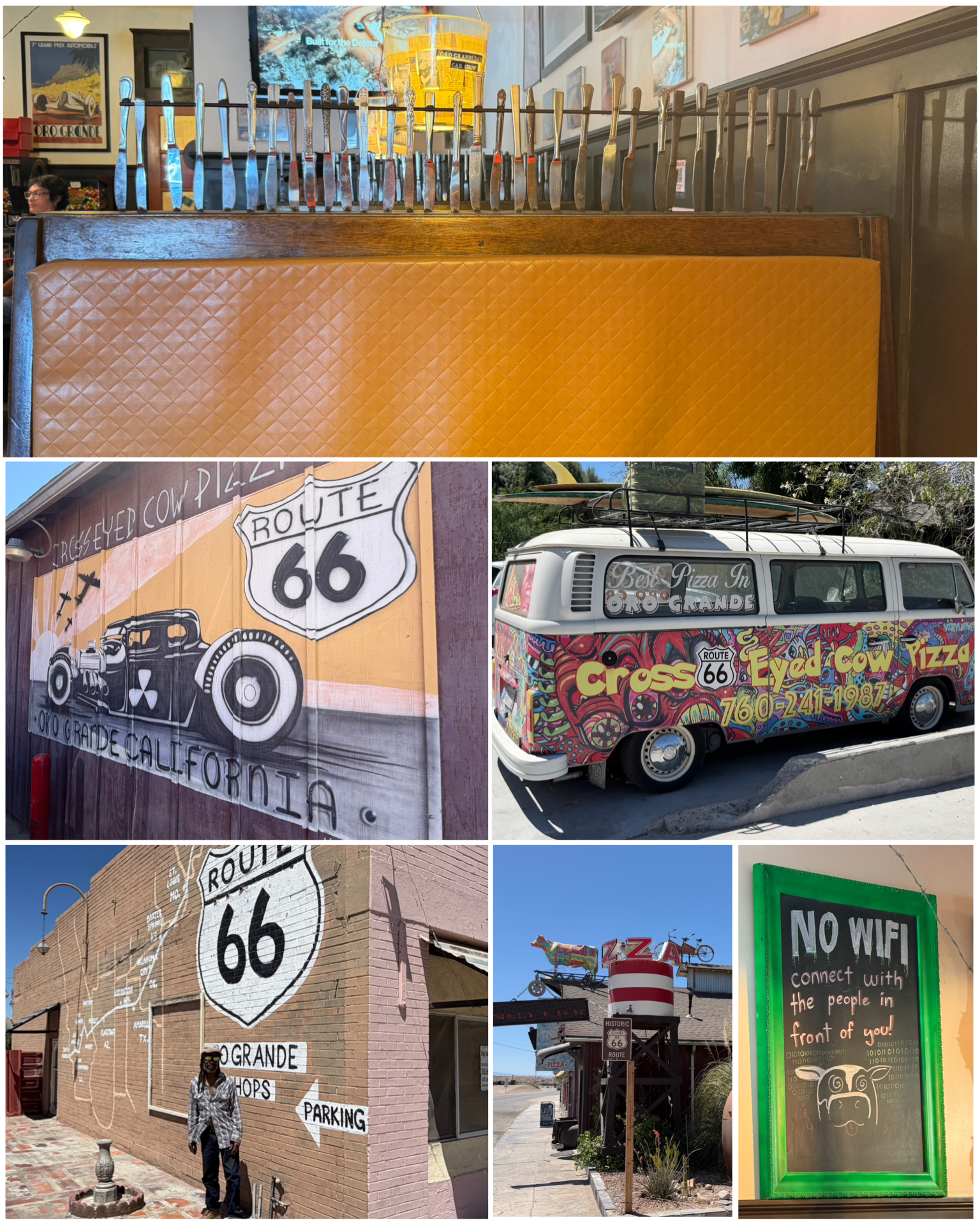 Further down the road in what would be considered downtown Oro Grande, were a couple of additional Rt 66 attractions. First up was the Cross Eyed Cow Pizzeria. What was once a circa 1920s Studebaker repair shop, has been converted into this crazy eclectic pizza pie place. The outside of the building features the namesake colorful cow known as Borden Elsie sitting atop the building with all sorts of additional crazy elements. Inside, the booth dividers feature backings made from knives, and chandeliers made from spatulas. I particularly appreciated the sign that provided notice of No Wifi in the place, and rather suggested you connect with the people in front of you. Oddly enough, I later captured a picture of a family including three young kids sitting directly beneath this sign – each staring at their cell phones. Geez! Next door was another building that was a sort of mini strip mall offering storefronts to local small businesses. I happened to run into one of the building’s owners (at left, bottom left) who shared with me a bit of the history of the place. He mentioned that he had done quite a bit of restoration of the building, adding individual bathrooms to each of the suites, and pretty much making the place habitable. Back before COVID, each of the six little
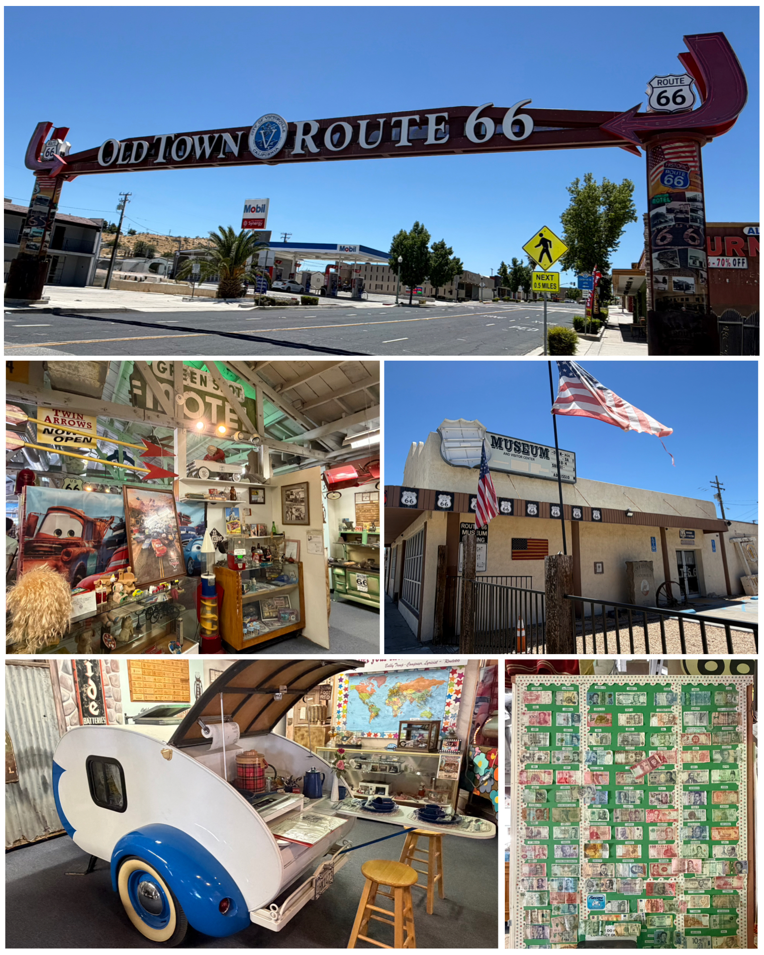 storefronts were pretty much fully occupied as a result of all these updates. Sadly, the pandemic wiped out all of their tenants and the now restored building once again sits mostly empty. Hopefully, they can get them filled up once again!
Last up on this days adventure takes me to Victorville, and the California Route 66 Museum. The museum featured lots of artifacts from the old Rt 66 days including a neon sign from the Victorville Green Spot Motel, an old VW Love Bus in colorful hippie style, and a 1949 milkshake machine from Sparky’s Drive-in to name a few. I especially enjoyed the historic teardrop camper featured in a historic campsite setup (at right, bottom left) that represented camping back in the day. Certainly not the gucci camping I enjoy today! There was also a wall covered with a display of paper currency from all over the world – which represents the vast number of visitors, both local and foreign, that have passed through the museum. Pretty cool! Also in town, serving as sort of a welcome to historic Rt 66 travelers, is this really cool archway sign that spans across Rt 15 as it intersects with Rt 66. Nicely done Victorville!
The next day I traveled Rt 66 to the east from my camping spot to explore all there was to see in that direction. I typically drive out to the farthest point to visit, then work my way back stopping at all the things I would have gone past along the way. That seems to work out best. So, in this case I would drive out the 1 hr 45 min taking me out about 90 miles to the east to my first stop. Actually, that farthest stop was actually far in the middle of nowhere in the Mojave Desert to see the Road Runner’s Retreat – a onetime truck stop and cafe out in the middle that offered respite to travelers during Rt 66’s heyday. However, the main road that would be Rt 66 leading up to this place was closed about 8 miles short necessitating a bypass onto an unmarked dirt road. In the end, the only thing to see there would have been the Roadrunner sign as the building had long since been closed and partially burned down from a fire. Having gotten the truck stuck on a sandy Arizona dirt road once before, I opted to skip this minimally interesting attraction after all.
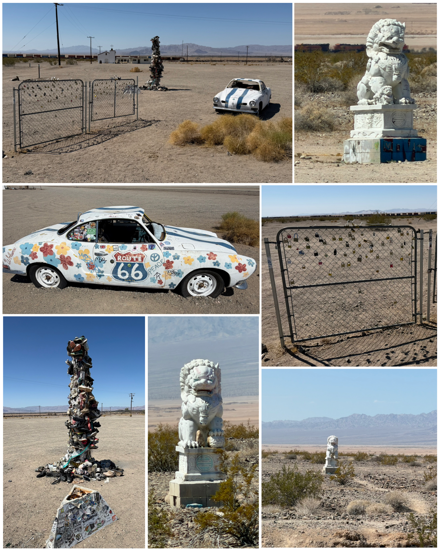 So, I circled back to the west towards Amboy to check off the next stop on the list. There, in the middle of the desert with absolutely nothing else surrounding them, were these two Chinese lion sculptures. Standing tall out in the desert about one half mile from each other, they have garnered the nickname guardian lions. Each made of marble and weighing several thousand pounds each, they were apparently put there in 2013 – but unknown who put them there. That remains a mystery and today they simply serve to guard Rt 66 travelers that muster along this arid remote section of the highway. Strange! Next, in what would be downtown Amboy is what has been coined the debris post. Somewhere along the line, someone decided to nail some random excess items onto what was once a utility pole. Well, that trend continues and the pole is now fully covered with various clothes, shoes, purses, or pretty much any random junk that someone has decided to stick here. Also placed here, though I could not find any reference to it having been added, was a two-panel fence covered in love locks, and an old sports car painted Rt 66 themed. Definitely some random things in an otherwise vacant area of the desert.
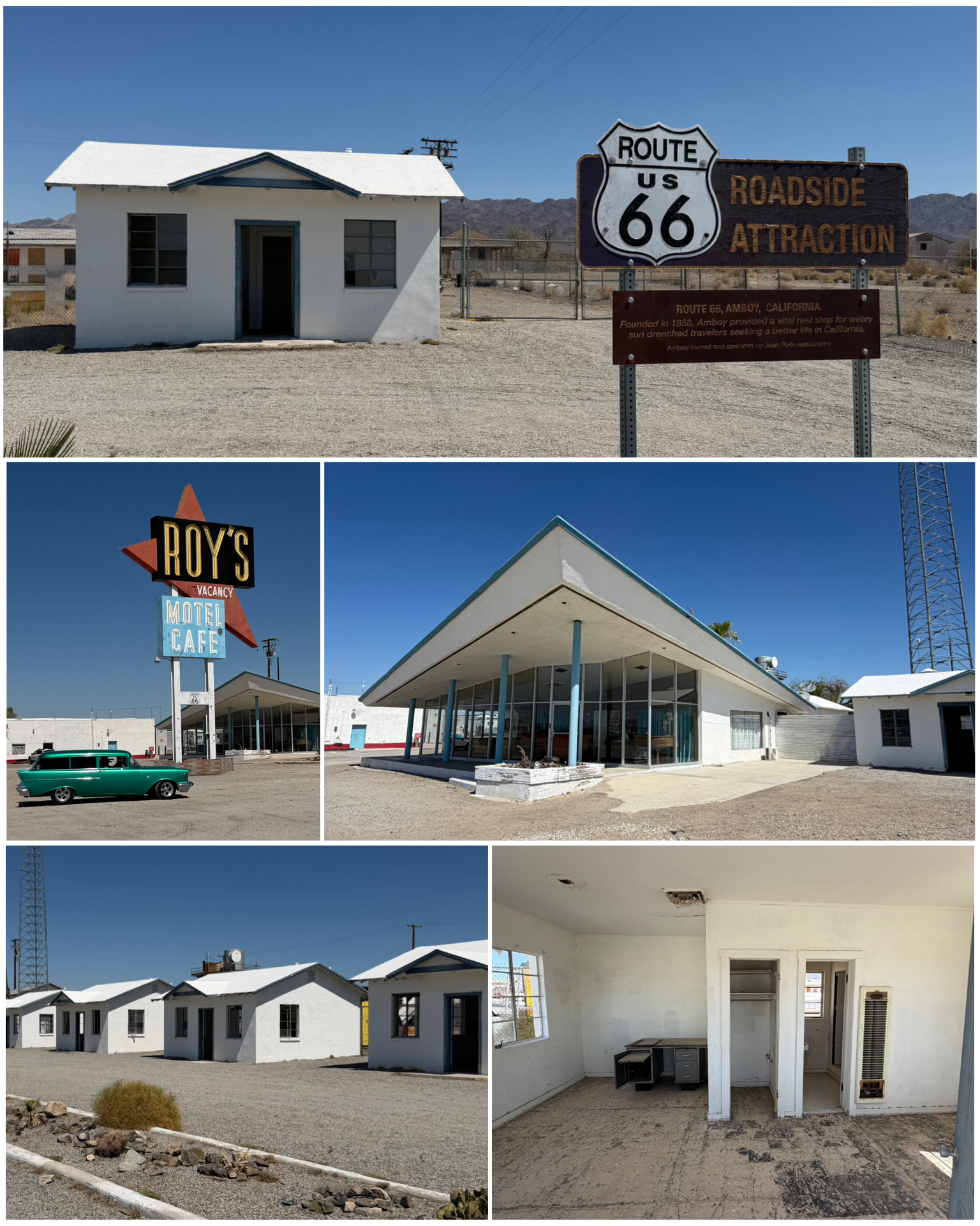 Just across the street also in Amboy was Roy’s Motel and Cafe. Roy Crowl opened a gast station in 1938 to serve the Rt 66 desert traveller. In the 1940s, a cafe and motel rooms (at right, center and bottom) were added. The rooms were little individual cottages (at right top and bottom right) – each having what would likely have been a bathroom, sleeping area, and perhaps sitting area. In 1959, a 50-foot tall neon sigh (at right, center left) was added that could be seen for miles in either direction and is proclaimed to be the most popular and photographed Rt 66 neon sign. When the nearby interstate opened in 1973, that was the end of Roy’s. Roy later died, and the neon sign went dark in the 1980s. Yet another victim to the progress that was interstate transportation.
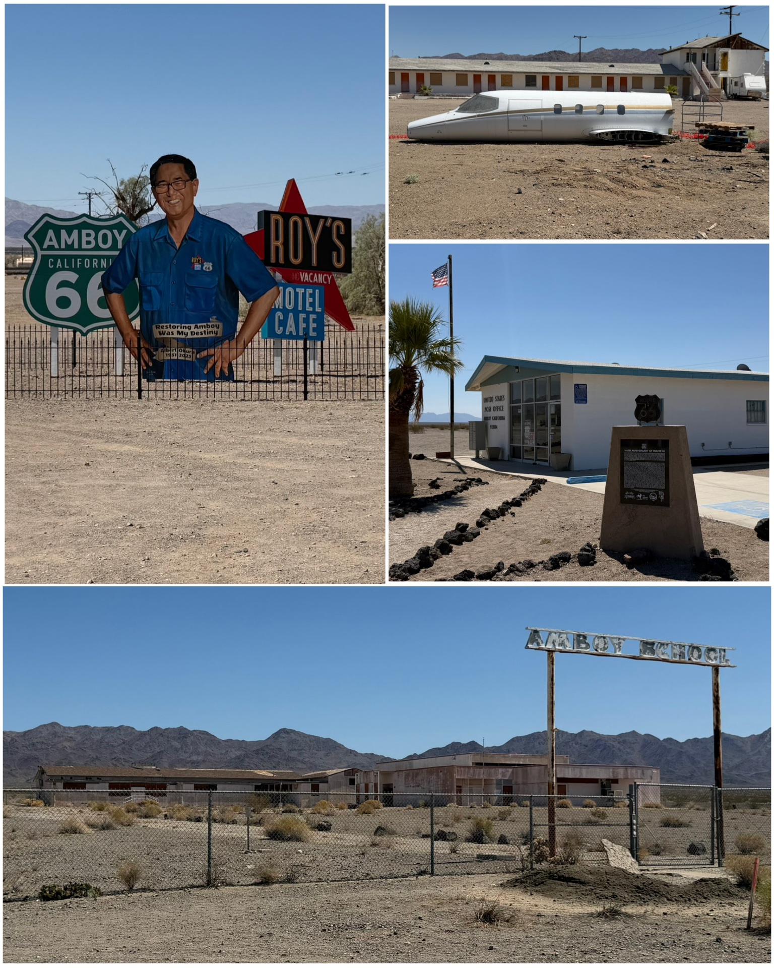 Across from Roy’s was the Amboy post office – nicely outfitted with historic Route 66 signage (at left, center right). Despite it being pretty much surrounded by businesses long since closed, this tiny Rt 66 landmark remains a functional and operating USPS facility. According to Wiki, as of 2020, the town’s business district still contained a post office, a historic restaurant-motel, and a Route 66 tourist shop, all operated by the town’s population of four people. As of 2024, only the gas station was open, and the population was zero. Not sure how this little post office survives! 2005, businessman Albert Okura bought the entire town of Amboy, having the goal to revive Roy’s back to its 1950s glory. Albert was the owner of the Juan Pollo chicken restaurant chain, as well as owner of the original McDonalds Museum in San Bernardino (visited and journaled in a recent blog). He and his son Kyle had gotten to work on the restoration. First up was the neon sign which was repaired and turned back on in 2019. Sadly, Albert passed away in 2023 and it would appear no ongoing restoration is in the works. In 2024, a sort of memorial for Albert Okura (at left, top left) was constructed across the street from Roy’s to recognize him and his efforts to revitalizing the town of Amboy. Behind Roy’s was what appears to have been another motel – but seemingly now is a storage for all sorts of things including this plane fuselage (at left, top right). A short distance down the road was the remnants of what was once Amboy School (at left, bottom). The original Amboy school was a small two-room building built in 1903 and was initially located by the railroad tracks. It is believed to have been moved to this location in the late fifties and early sixties. The school closed completely in 1999 when most of all of the Amboy families had moved away creating what is now basically a ghost town.
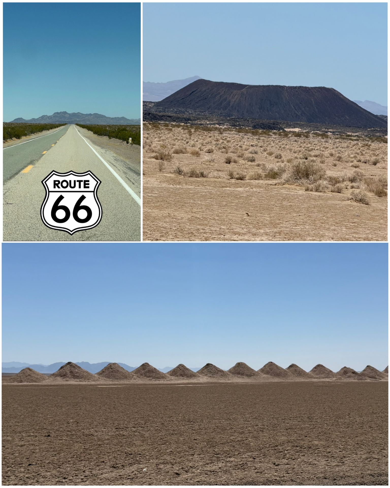 Just west of Amboy were a couple of interesting landmarks. A mile or so south of Rt 66 were these rows of what appear to be pyramids (at right, bottom). Though not necessarily a Rt 66 attraction, I decided to check them out as they were items of interest listed on Roadside America. There are hundreds of these mounds sitting in a dry lakebed once known as Bristol Lake. Apparently, these pyramid-like mounds are a byproduct of active salt mining activity on the lakebed. According to one account, this mining produces the bulk of sodium and sodium chloride used in high school chemistry classes. Who knew? Next up, is this 250 foot high volcanic cone and crater in the middle of the desert. It’s estimated to be 80,000 years old, and can be hiked to for up-close exploration. However, the hike is reported to be pretty long from the parking area, and with the triple-diget heat and additional warnings of rattlesnakes, I opted instead to admire it from afar.
With the surrounding mountain ranges and desert for miles on end, this sure was a pretty place to visit. One particular long-shot view of Rt 66 leading up to a far away mountain range was a perfect photo op (at right, top left). Sure could have used a painted Rt 66 logo here on the street!
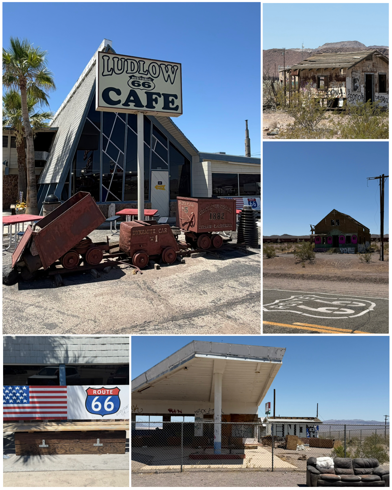 About 30 miles back further to the west on 66 is the town of Ludlow. Here I would find a number of what I would call extinct businesses including the former Whiting Brothers gas station (at left, bottom right), and who knows whatever else once resided at these decrepit places (at left, top and center right). Certainly something from the greater days of Rt 66. Then I arrive at this cool place – the Ludlow Cafe. Decorated and filled with Rt 66 nostalgia, this is a reconstructed version from the original Rt 66 cafe that was bypassed by the new interstate and ultimately abandoned. This 1970s version was built in close proximaty to an exit off the new Interstate which has allowed it to thrive and survive. Besides the Rt 66 themes, the small red rail cars in front pay homage to the towns mining heritage. Also, there was an interesting monument (not pictured here but is included in the full photo album link at the bottom) memorializes Project Carryall. This project was to realign several railroad routes along with the creation of Interstate 40. This required clearing out millions of tons of rock from the nearby Bristol Mountains. It was originally proposed to use 23 nuclear-based explosions to excavate the 2-mile and 350 feet deep of mountainous rock. Health and safety concerns were raised, and the project was eventually scrapped. Wow – that was a close one!
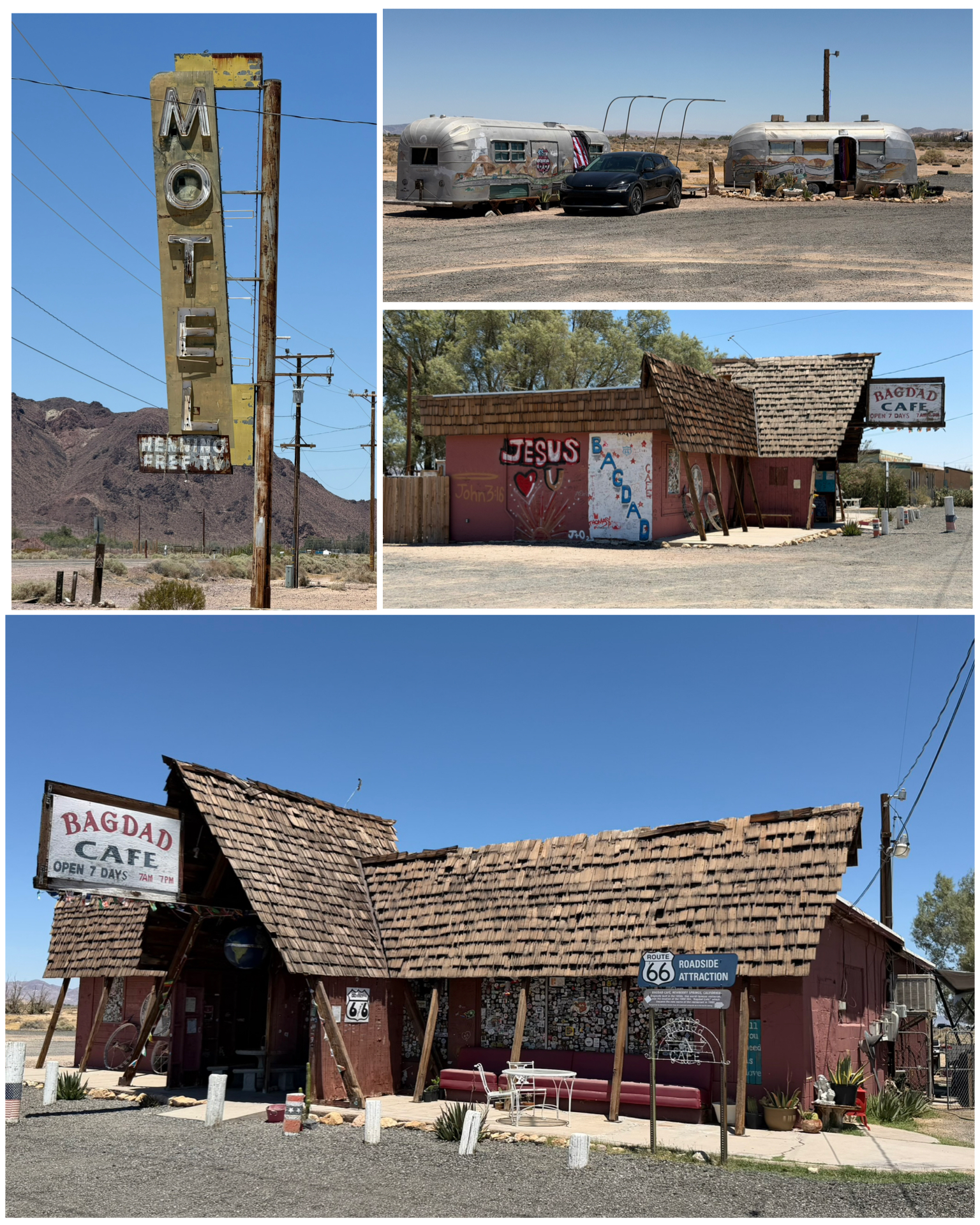 The final stop along this eastern portion of route 66 takes me to the town of Newberry Springs some 30 additional miles to the west of Ludlow. Here we find the Bagdad Cafe. While not originally a vintage Rt 66 destination, it sure has adopted the Rt 66 nostalgic themes. Originally called the Sidewinder Cafe, it was featured as the filming location of the German 1987 movie “Bagdad Cafe” (available for streaming on Amazon Prime). While the actual town of Bagdad, CA some 50 miles to the east did in fact have a Bagdad Cafe, it was decided to use the cafe here in Newberry Springs as the filming location. The movie script was supposedly inspired by a road trip across Rt 66 taken by the movie’s writers and directors Percy Adlon and his wife Eleonore in 1984. Apparently the nearby towns of Barstow and Daggett were also filming locations for the movie. The signage outside the cafe stated open 7 days a week, 7am to 7pm. However, there was absolutely no signs of life while I was there. The motel, also featured in the movie, was torn down in 2015, leaving only the original neon sign (at right, top left). Interestingly, in the otherwise empty parking lot, were a pair of airstream RVs seemingly living there full time. Again, I didn’t see anyone around, and but for the fact that there was a car parked in front of one of the RVs, I might have otherwise thought them to have been abandoned too.
Epilog: Just prior to publishing this blog, I took the opportunity to watch the Bagdad Cafe movie. It won several awards and though certainly dated, it is truly a pretty interesting if not a bit quirky film. In addition to seeing the cafe and surrounding area featured in the movie, there was also an Airstream RV featured in the film – which may explain the ones I saw when I visited.
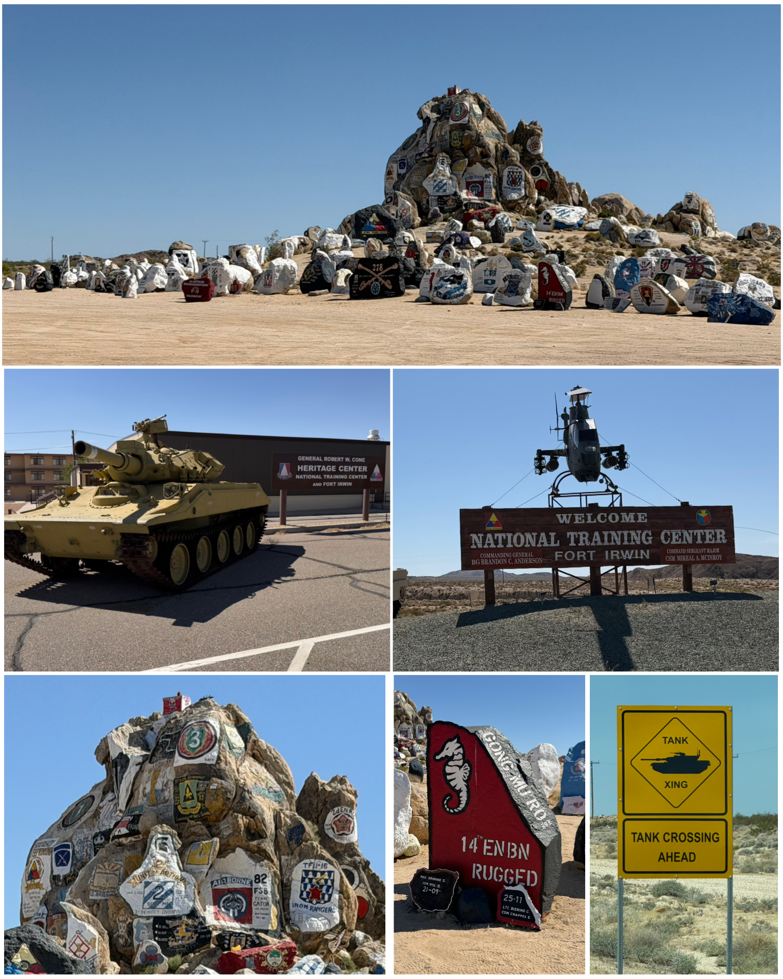 While there are certainly more than enough Rt 66 attractions to keep me busy, I still check Roadside America to see if there is anything noteworthy to check out in the area. One such place that peeked my interest was this place – Fort Irwin, just over 30 miles to the north. Besides the interesting entrance sign (at left, center right), it was the painted rocks that mostly intrigued me. Fort Irwin is home to the National Training Center – a state of the art 1,000 square mile facility in the Mojave Desert. In addition to providing tank training, the center also provides opposing forces training where true-life simulated warfare is practiced using both opposition forces, as well as building and fighting in enemy-like villages complete with unpredictable townsfolk, snipers, and even roadside bombs to perfectly simulate modern urban warfare. 13 such villages have been built – mostly representative of Iraq and Afghanistan. Starting in 2008, they used to offer public tours of the villages four times a year, but apparently they have been suspended. The highlight of the trip was the painted rocks. Several years ago, one of the squadrons visiting and going through training at the center climbed atop a pile of rocks and painted their company color on one of the rocks. That started a trend and as all future military units arrived and were trained, they too painted their unit logos and mottos on the rocks. What exists today is an amazing collection of military training history. Truly incredible! There was also a museum on the post that featured history and artifacts from the camp dating back to the early 1900s. I wasn’t sure if I could get on the post, but a trip to the visitor center at the entrance and a quick background check was all that was needed for me to have access. Unfortunately though, despite the museum having operational hours during my visit, I suspect they don’t get a lot of visitors, so it was closed. There was a sign on the door with a phone number to call for a visit, but when I called it rang consistently only to be answered by a message stating the voicemail box had not been setup. Typical government! But the rest of the visit was worthwhile enough for me to have taken the trip.
Final Thoughts
 Well, I was actually going to include all the places I have already visited while in Needles. However, as I wrapped up all the places I went to just while I was in Yermo, I quickly realized this was certainly enough to write about in this blog edition. So, I’ll likely have another edition coming out in a few days so that I can catch up. I’m quickly discovering that is so much to see here along Rt 66, that I need to do a better job of keeping up with the writing or I will otherwise quickly get behind. My next stop is yet another hot climate location, with projected triple digit temps pretty much the full week I’ll be there. Definitely going to give those new ACs a workout. Till next time, be well and safe travels.
I only show a sampling of my adventure pictures here in the blog, and do so mostly in collage format for brevity and ease of reading. If you want to view an album containing individual full fidelity and hi-res images of all my travel pictures related to this specific blog, click the image below. Enjoy!

One week and counting until I get to face the triple digit temps, unless it cools off a bit by then. Interesting blog and I remember much of the attractions especially the bottle trees. See ya soon.
Wonderful blog. You certainly do your research on the places you visit. Walter and I are traveling back to Western NY today. We enjoyed our visit with our adorable granddaughters. It was also very nice California weather – not triple digit. Safe travels.